News
03/27/2023, 10:40 am EDT

Equatorial East Pacific Warming Impressive – Signals El Nino on the Way!

The upper ocean heat in the equatorial East Pacific is warming sharply. An old Kelvin Wave shifting eastward arrived on the northwest coast of South America the past 1-2 weeks and has caused steady impressive warming in the Nino12 SSTA region. A new Kelvin Wave has shifted east of the Dateline to about 145-140W longitude. The new Kelvin Wave is forecast to reach the northwest South America coast by early May.
03/21/2023, 3:41 pm EDT

Are We Heading Toward an El Nino Summer in the Tropics?

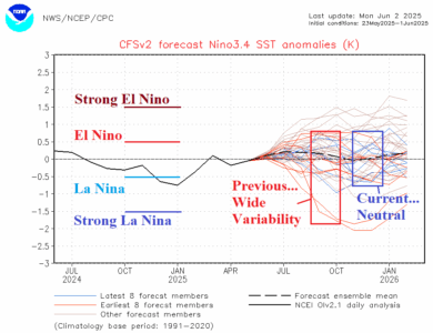
Dynamic ENSO phase forecast models are indicating a full-tilt El Nino by August 2023. Implied is a tropical cyclone season in the North Atlantic basin possibly similar to the last full-throttle El Nino that suppressed North Atlantic activity. Below normal rainfall was observed during JUL/AUG/SEV 2015 across the Southern U.S., Gulf of Mexico, and western North Atlantic tropics.
03/17/2023, 8:31 am EDT

-PNA climate pattern regenerates, tough to break.

Since late January, the Pacific North America (PNA) index has shifted to a (mostly) steady negative phase. A brief positive phase is with us now, but strengthening negative phase returns in the latest 15-day forecast. The -PNA pattern occurs when an upper-level troughing in the jet stream pattern occurs just off the North America West Coast. The persistence of the -PNA pattern has caused the Northeast Pacific to cool, the Northeast Pacific marine heat wave (MHW) to shift westward and reinvigorate the cool phase of the Pacific decadal oscillation (-PDO).