02/02/2025, 11:43 am EST
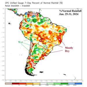
Ongoing drought risk across Argentina and Brazil as mid-meteorological summer 2024-25 has passed remains intense. Forecast models have generally been over-forecasting rainfall, especially in Brazil. During January, anomalous heat dominated Argentina. Despite periodic rainfall, mid-summer heat accelerates drying soils.
