News
05/30/2022, 9:49 am EDT

Madden Julian Oscillation Shifts to Atlantic in Early June Increasing TC Risk

The convection phase of the Madden Julian Oscillation has shifted into the tropical East Pacific and helped trigger Hurricane Agatha. Forecasts indicate the MJO shifts to the tropical Atlantic in early June which supports tropical cyclone activity development - most likely in the Gulf of Mexico.
05/27/2022, 9:55 am EDT

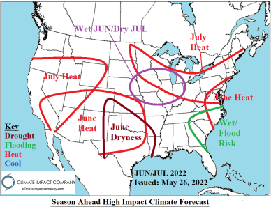
Projected U.S. High Impact Climate June Through September

The primary concerns heading into summertime are drought (and attendant anomalous heat) and coastal tropical cyclone risk. The JUN/JUL 2022 outlook emphasizes dryness (and anomalous heat) across Texas and into the Southwest States. Drought in this region, particularly Texas strengthens. The Midwest States are wet in June and flip very dry mid-summer.
05/23/2022, 12:32 pm EDT

Oceanic La Nina Moderately Strong; La Nina Atmosphere Very Strong

The Nino23 SSTA regions remain consistent in the moderate intensity of La Nina range for mid-May. However, mostly very negative daily southern oscillation index implies the atmosphere is locked-in on strong La Nina presence. Models are indicating some weakening of La Nina for just-after mid-year but no signs of that weakening yet.
05/16/2022, 6:42 am EDT

Evaporative Drought Demand Index Foreshadowing Summer 2022 Drought Areas

The current U.S. Evaporative Drought Demand Index (EDDI) clearly identifies much of the southern half of the U.S. as rainfall starved with attendant worsening dry to drought soil moisture. The driest EDDI is located over the Desert Southwest, south-central Nebraska, and parts of eastern Kentucky, the eastern Carolinas and Florida. The northern U.S. has benefited from cool temperatures, snowmelt and wet periods to cause a EDDI wet surplus.