Evaporative Drought Demand Index Foreshadowing Summer 2022 Drought Areas
05/16/2022, 6:42 am EDT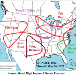
Projected U.S. High Impact Climate June Through September
05/27/2022, 9:55 am EDT
Fig. 1: Subsurface equatorial Pacific Ocean temperature anomalies with annotated trends.
Discussion: The equatorial Pacific Ocean subsurface identifies several interesting features from May 2022 (so far). The Kelvin Wave near and just east of the Dateline during most of spring has extended farther east to almost 140W (Fig. 1). However, the strength of the eastward extension and the core of the Kelvin Wave near the Dateline is slightly less warm than 1-2 weeks ago. Additionally, the subsurface to 100 meters depth near and west of the Dateline has cooled. Waters in the eastern Pacific are also cool and remains quite cool off the northwest coast of South America. The Nino SSTA regions remain steadily in neutral ENSO phase (Fig. 2). Remarkably, the daily southern oscillation index is at a robust La Nina-like -2.2 today and has averaged -1.9 the past 30 days which implies the atmosphere is locked-in to a fiercely intense La Nina pattern. Many dynamic models are trending toward La Nina weakening during the northern hemisphere summer possibly to neural phase of a very weak La Nina as the updated ECMWF forecasts indicates (Fig. 3).

Fig. 2: The Nino SSTA observations for the past 12 weeks.

Fig. 3: The ECMWF latest Nino34 SSTA forecast.