News
05/31/2020, 2:23 pm EDT

Explaining Recent Tendency for Stalled U.S. Coastal Tropical Cyclones

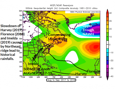
Important to seasonal prediction of North Atlantic tropical cyclone activity is the evolution in recent years of the North Atlantic Warm Hole and the attendant upper air pattern. During the tropical cyclone season a persistent upper level trough has formed in the cooler atmosphere across the NAWH compensated for by a persistent upper ridge over Quebec (and vicinity). When the upper ridge is present as tropical cyclones go inland the U.S. coastline storms slow down and produce excessive rainfall similar to Harvey (2017), Florence (2018) and Imelda (2019). A similar dynamic is expected for AUG/SEP 2020.
05/31/2020, 2:19 pm EDT

Explaining Recent Tendency for Stalled U.S. Coastal Tropical Cyclones

Important to seasonal prediction of North Atlantic tropical cyclone activity is the evolution in recent years of the North Atlantic Warm Hole and the attendant upper air pattern. During the tropical cyclone season a persistent upper level trough has formed in the cooler atmosphere across the NAWH compensated for by a persistent upper ridge over Quebec (and vicinity). When the upper ridge is present as tropical cyclones go inland the U.S. coastline storms slow down and produce excessive rainfall similar to Harvey (2017), Florence (2018) and Imelda (2019). A similar dynamic is expected for AUG/SEP 2020.
05/29/2020, 8:31 am EDT

Why La Nina Could Be Stronger

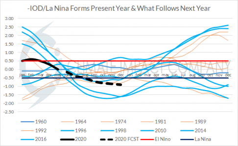
Global SSTA models are forecasting a major contrast between ocean surface temperatures across the eastern equatorial Pacific (cool) versus the far western Pacific and eastern Indian Oceans (warmer). The contrasting ocean temperatures lead to stronger trade winds across the eastern Pacific tropics possibly increasing La Nina strength and duration.
05/27/2020, 8:06 pm EDT

Energy Daily Report: Medium-range tropical cyclone risk/Central U.S. heat

Highlight: Medium-range tropical cyclone risk/Central U.S. heat Fig. 1-2: The day-10 forecast of a possible tropical system near or in the Gulf of Mexico by the GFS and ECM. Discussion: The climate pattern becomes favorable for a possible tropical cyclone generating in the deep tropics during the medium-range. The risk area is across or near the Yucatan Peninsula according to GFS (Fig. 1) or already into the Bay of Campeche by ECM (Fig. 2). If the system is into the Gulf of Mexico the ECM ENS indicates the favored landfall target is the Texas Coast in 12-13 days. Meanwhile to the north of the convection-active tropics warm air is pumped into the middle atmosphere in the Central Great Plains amplifying an upper ridge pattern and increasing the risk of >90F/>95F in both the 6-10 and 11-15 day periods (Fig. 3-6). The latest mega-cluster forecast indicates an increasing risk of an amplified upper ridge centered on Wisconsin in the 11-15 day period (Fig. 7). Fig. 3-4: The 6-10 day risk of >90F and >95F. Fig. 5-6: The 11-15 day risk of >90F and >95F. Fig. 7: Mega-cluster depiction of the upper air pattern in 11-15 days.