Why La Nina Could Be Stronger
05/29/2020, 8:31 am EDTThe 2020 Hurricane Season: Busiest Year Since 2010 And 2012. Several Gulf Hurricanes Are Indicated.
06/02/2020, 4:43 pm EDT
Discussion: Due to the increasing rapid ice melt of the Greenland Ice Sheet during spring and summer an annual large deposit of fresh water has accumulated south of Greenland in the north-central North Atlantic basin most vivid and consistent beginning in 2013. The fresh water melt has caused a consistent large pool of cooler than normal water to persist year-round in this region partially blocking the usual warming influence by the Gulf Stream. Climate scientists have named the cool pool of water the North Atlantic Warm Hole (NAWH) due to the presence of the cool pool in an otherwise warmer than normal North Atlantic basin (Fig. 1).
Aloft the air has also cooled across the NAWH and during the peak of the tropical cyclone season has caused a persistent upper trough in the North Atlantic compensated for by a blocking high pressure ridge over Quebec (Fig. 2). The high pressure ridge has remained in-place during the past 3 years (Fig. 3) playing a significant role in slowing tropical cyclones making landfall in the U.S. and preventing the usual north turn and acceleration. This dynamic caused historic rainfall each of the last 3 tropical cyclone seasons due to Harvey (2017), Florence (2018) and Imelda (2019).
At the onset of the busiest time of tropical cyclone season (Aug. 1) the North Atlantic SSTA analysis identifies the NAWH for each of the past 3 seasons (Fig. 4-6). A similar regime is present now (Fig. 7) and will continue for upcoming tropical cyclone season.
Summary: Important to seasonal prediction of North Atlantic tropical cyclone activity is the evolution in recent years of the North Atlantic Warm Hole and the attendant upper air pattern. During the tropical cyclone season a persistent upper level trough has formed in the cooler atmosphere across the NAWH compensated for by a persistent upper ridge over Quebec (and vicinity). When the upper ridge is present as tropical cyclones go inland the U.S. coastline storms slow down and produce excessive rainfall similar to Harvey (2017), Florence (2018) and Imelda (2019). A similar dynamic is expected for AUG/SEP 2020.
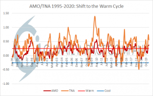
Fig. 1: Since the middle 1990’s the warm phase of the Atlantic multi-decadal oscillation has dominated (including the tropical counterpart) causing a general increase in North Atlantic tropical cyclone activity.
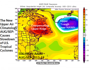
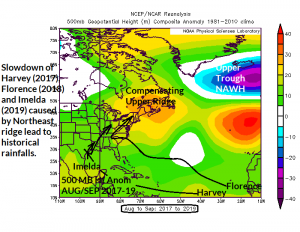
Fig. 2-3: Formation of the North Atlantic Warm Hole, an area of cool water south of Greenland beginning in 2013 has caused the atmosphere to cool (low pressure trough) compensated for by an upper ridge across Quebec (left). In 2017-19 the average position of the upper ridge is evident centered on Nova Scotia (right).
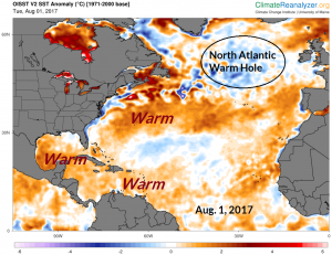
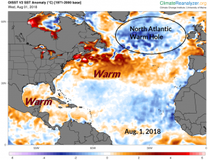
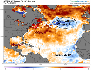
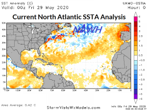
Fig. 4-7: The August 1st North Atlantic SSTA analysis identifies the NAWH each of the past 3 years. The NAWH is very intense this year as TC season begins.