01/31/2024, 2:48 pm EST

Arctic Air Watch for 3rd Week of February Issued

Stratospheric warming returns to Siberia in 12+ days. Risk of arctic air generating in Eurasia returns. If so, where does the air mass travel? The midday (Jan. 31) suggests the air mass evolves and may want to travel cross-polar into North America. The risk is still low but increasing for potential important cold in the U.S. Feb. 18-24.
01/30/2024, 2:27 pm EST

The Inaugural South America Year-2 Ahead Climate Forecast

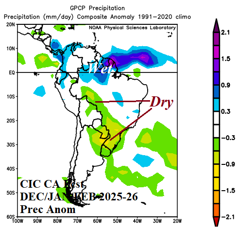
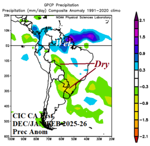
The inaugural year-2 ahead climate forecast for South America is issued. The forecast is valid for meteorological autumn 2025 through summer 2025-26. Forecast highlights include a strengthening Brazil drought shifting southward into Northeast Argentina.
01/28/2024, 1:22 pm EST

Super-Fast Jetstream Across Pacific Propelled by Madden Julian Oscillation

Late last week, there were reports of record-fast speed of jet airliners crossing the Pacific Ocean propelled by an unusually intense jet stream. Typical air speed of jet airliners flying at 37,000 to 41,000 feet is in the 550-600 mph range. Late last week, reports of air speeds near 825 mph were reported enabling trans-Pacific flights to arrive 90 minutes earlier than scheduled.
01/28/2024, 1:16 pm EST

Excessive Heat Argentina, Hot Pattern Australia, Heavy Precipitation Returns to Europe, China chill.

Extremes are ahead as February arrives. Featured is extreme heat risk in Argentina with an attendant dry climate. Parts of Australia have observed a much hotter than normal mid-summer and the heat becomes more extreme into early February. Mostly dry and mild this week in Europe but a vigorous storm track returns next week. The second cold outbreak of winter so far is heading for China during the medium range.
01/28/2024, 1:08 pm EST

Marine Heat Waves and Attendant Upper Air Pattern Influence on Australia Climate

Marine heat waves (MHW) southwest and east of Australia are strengthening during the summer season so far and affecting the prevailing upper air pattern governing the attendant Australian climate. The precipitation climate across Australia so far this summer season is much different from a typical El Nino climate!
01/25/2024, 8:26 am EST

Marine Heatwave Inspires Emerging South Africa Drought

Characteristic of climate change is the evolution of marine heatwaves (MHW) as part of the warming of the global ocean surface in recent decades, particularly the last 10-15 years. Climate Impact Company follows MHW’s closely and their potential atmospheric impact. A recent MHW forming southwest of Africa is intensifying.
01/24/2024, 5:46 am EST

Extreme Rainfall Episode Northwest Gulf States Continues

Flash Flood Warnings for life-threatening flooding is occurring across Interior East Texas and Southwest Louisiana. Flooding is also present in many parts of East Texas to central Arkansas and across the western half of Louisiana. More extreme rain is on the way centered on Louisiana the next 2 days.
01/24/2024, 4:24 am EST

Inaugural Year-2 Ahead Climate Outlook for North America

The Climate Impact Company inaugural year-2 ahead climate forecast for North America is issued. The forecast is valid for meteorological spring 2025 through winter 2025-26. Forecast highlights include a wet spring in Texas/Louisiana, a (nationally) hotter than normal summer, warmer than normal autumn, and possibly a vigorously warm winter 2025-26 season. Important dryness leading to drought emerges in Texas during the summer season and expands to the Mid-south States by autumn. The winter 2025-26 forecast is unusually dry.
01/22/2024, 8:06 am EST

Ice Storm Mid-south to Ohio Valley Today/Tomorrow

The erosion of the arctic air mass comes at a cost. A large ice storm in-place now in the Mid-South States extends to the Ohio Valley tonight. Ice accretion near or above 0.25 inches, which is enough to cause power outages, extends across AR/MO and near Chicago and eastward into tomorrow.
01/22/2024, 8:02 am EST

Upper Ocean Heat in Equatorial East Pacific Diminishing Fast Signaling El Nino’s Demise Ahead

The NCEP CFS V2 Nino34 SSTA forecast has relentlessly been forecasting a flip from the current strong oceanic El Nino to similarly intense La Nina by the end of 2024. Given the strength of the current El Nino and the general oceanic anomalous warmth poleward of the Pacific tropics, a rapid shift toward strong La Nina seems unrealistic. The latest NCEP CFS V2 Nino34 SSTA forecast insists on a decline in El Nino with neutral ENSO by April, weak La Nina by June, and strong La Nina by October. A recent development supportive of this forecast is the sudden loss of upper ocean heat across the equatorial Pacific Ocean.
01/21/2024, 4:22 pm EST

January 2024 Global Soil Moisture Trend

Entering 2024, drought concern in the southern hemisphere was present across Brazil, South Africa, and much of Australia. Interestingly, the drought focus as mid-summer approaches in Australia shifts to the western continent as heavy rains have affected parts of the East while the wet monsoon has emerged across the North. In South America, Argentina drought is nearly dissipated although short-term forecasts are hot and dry. Meanwhile, a dry start to summertime in Brazil reverses wetter in January.
01/21/2024, 12:43 pm EST

Wet Brazil And Dry/Hot Argentina Next 2 Weeks

A stubborn upper-level low pressure area in Southeast Brazil persists the next 10 days and erodes in the 11-15-day period. A compensating subtropical ridge extends into Argentina through 10 days. The result is anomalous heat and dry climate across Argentina while heavy rains drop anchor on East Brazil. The week-3 ahead forecast indicates the pattern described is fading.