Wet Brazil And Dry/Hot Argentina Next 2 Weeks
01/21/2024, 12:43 pm ESTExtreme Rainfall Episode Northwest Gulf States Continues
01/24/2024, 5:46 am EST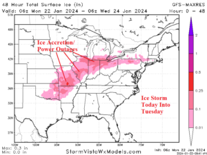
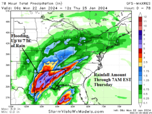
Fig. 1-2: 06Z GFS 48-hour ice accretion and 72-hour rainfall forecast.
Discussion: The erosion of the arctic air mass comes at a cost. A large ice storm in-place now in the Mid-South States extends to the Ohio Valley tonight. Ice accretion near or above 0.25 inches, which is enough to cause power outages, extends across AR/MO and near Chicago and eastward into tomorrow (Fig. 1). Meanwhile, heavy rain with embedded strong thunderstorms emerges over East Texas, Arkansas, and Louisiana today lasting through tomorrow and edging slightly eastward by midweek. Excessive rainfall causing flooding is likely in these 3 states. GFS conservatively forecasts up to 7 inches (Fig. 2) but >10 inches are certainly possible in areas hit several times by heavy rains.
A Pacific atmospheric river pattern brings heavy precipitation to the Northwest States this week. In the 8-14/11-15-day period, the atmospheric river pattern will return, bringing excessive rains to California (Fig. 3).
Finally, implications for major climate pattern change in 2024 ahead as subsurface heat fueling El Nino 2023-24 are declining rapidly (Fig. 4). Forecasts for La Nina later this year are more likely. Full details/implications ahead this week.
The U.S. gas population weight HDD forecast continues to indicate a sharply lower heating demand ahead (Fig. 5).
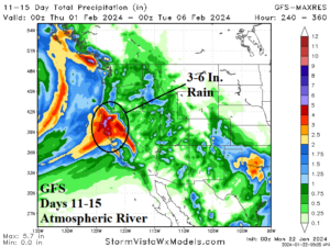

Fig. 3-4: 06Z GFS 11-15-day precipitation forecast for the Western U.S. and rapidly declining upper ocean heat in the equatorial East Pacific.

Fig. 5: The U.S. gas population weight HDD forecast utilizing all models, their consensus, and comparing with 24 hours ago and the 10-year/30-year normal.