A Check on Europe HDD Forecasts
01/16/2024, 2:25 pm ESTIce Storm Mid-south to Ohio Valley Today/Tomorrow
01/22/2024, 8:06 am EST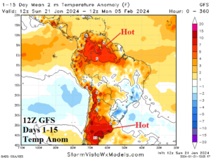
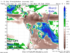
Fig. 1-2: The 12Z GFS 15-day temperature anomaly and percent of normal rainfall forecast across South America.
Discussion: A stubborn upper-level low pressure area in Southeast Brazil persists the next 10 days and erodes in the 11-15-day period. A compensating subtropical ridge extends into Argentina through 10 days. The result is anomalous heat and dry climate across Argentina (Fig. 1) while heavy rains drop anchor on East Brazil (Fig. 2). The week-3 ahead forecast indicates the pattern described is fading.
In Australia, a nearby convection phase of the Madden Julian oscillation (MJO) will cause development of a tropical cyclone that forecast models indicate becomes a major tropical cyclone that strikes Queensland late this week. Northern Australia is within a wet monsoon regime inspired by the MJO. South of where rainfall is not occurring, the remainder of Australia is extremely hot (Fig. 3-4).
Cold weather in Europe and Northwest Eurasia fades as a maritime influence from the North Atlantic increases and causes Europe to turn warmer and arctic air to depart Northwest Russia (Fig. 5). The GFS indicates Northwest Eurasia may turn colder in the medium range while other models are somewhat warmer. Southwest Europe is dry and the area of mostly rainfall is stretched across Eastern Europe, Southwest Russia, and the Black Sea region (Fig. 6). Northern Europe/Northwest Russia may turn cold air in the week-3 ahead time frame.
Finally, the 12Z GFS maintains the big warm-up in the U.S. over the next 2 weeks (Fig. 7). The southern half of the U.S. is stormy (Fig. 8). An “atmospheric river” pattern may be developing across the Pacific to enhance U.S. storminess ahead. This week, much of the precipitation is snow as lingering arctic air remains while medium-range forecasts favor mostly rainstorms.
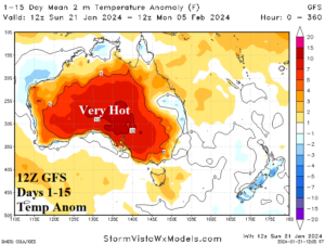
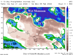
Fig. 3-4: The 12Z GFS 15-day temperature anomaly and percent of normal rainfall forecast across Australia.
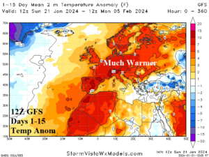
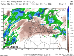
Fig. 5-6: The 12Z GFS 15-day temperature anomaly and percent of normal rainfall forecast across Europe.
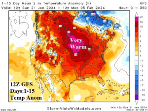
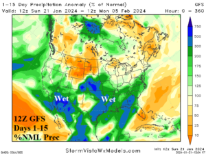
Fig. 7-8: The 12Z GFS 15-day temperature anomaly and percent of normal rainfall forecast across the U.S.