07/31/2020, 7:48 am EDT

Hurricane Isaias To Affect The Entire U.S. East Coast!

Miraculously Isaias survived the trek across Hispaniola as a minimal hurricane and will now reorganize over the warm waters of the Bahamas to a category 2 hurricane by tomorrow. Isaias is forecast to turn north and north-northeast staying just off the East Coast of the U.S.
07/28/2020, 8:14 pm EDT

Modern-day La Nina Climatology for SEP/OCT Plus NOV/DEC

La Nina climate is most profound during the cool season. In 2020 a moderate La Nina is forecast to begin in late quarter 3. Since the mid-to-late 1990’s three separate weak-to-moderate La Nina episodes have occurred: 2000, 2007 and 2016. A simple average climate pattern of those 3 analog years for SEP/OCT and NOV/DEC is issued for North America, Europe, South America and Australia.
07/27/2020, 5:29 am EDT

Explaining The Unusually Wet India to China Pattern

During the past 2 months an arc of persistent heavy rainfall has extended from the western half of the tropical Indian Ocean northeastward across parts of India and northeastward from there into China and more recently Japan. The moderate-strength and stalled Madden Julian oscillation is the catalyst.
07/26/2020, 12:35 pm EDT

Northeast Corridor Heat Wave Starts the Week

A Northeast Corridor heat wave begins today. An Excessive Heat Watch is in effect for parts of southern New England valid through 8PM EDT Monday. Heat advisories are in effect for much of the remainder of New England south to the New York City area. Today’s hot weather is without high humidity. However, high dew points arrive tomorrow forcing widespread 105F heat index (or higher) which will last into Tuesday.
07/25/2020, 6:56 am EDT

Hanna Roars Into Southern Texas as a Hurricane Today

An ideal environment for intensification - low shear and very warm surface water - causes Hanna to become a hurricane slamming the south coast of Texas just south of Corpus Christi this afternoon.
07/19/2020, 11:58 am EDT

Tracking Peak of Summer Heat Waves

Does another heat wave follow the current episode for next weekend? ECMWF says yes and forecasts a stronger event than currently taking place. The GFS is not nearly as hot. The question is whether the hot air source region in the Central U.S. pulses eastward (or not). GFS says no while ECM is (vigorously) yes! The precedent is set as last week’s Midwest heat wave has shifted into the East now. A second event is likely and given peak summer heat the next event could be hotter.
07/15/2020, 8:24 am EDT

MJO Causes Record Slow Start to West Pacific TC Season

The Pacific tropical basin has observed no significant tropical cyclone activity since early June including no category-3 systems, the first time in the satellite measuring era (since 1966) according to the Australia Bureau of Meteorology. Using accumulated cyclone energy (ACE) index the seasonal activity (so far) for the Pacific basin is 20% of normal.
07/13/2020, 9:31 am EDT

The La Nina In 2020 Forecast Is In Jeopardy

The subsurface equatorial Pacific to the east of the Dateline is losing a moderate-strength cool signature which developed in May and signaled La Nina ahead. In recent weeks the cool anomaly has nearly disappeared. Subsurface support for La Nina evolution will need to rebuild.
07/12/2020, 11:26 am EDT

Why The Tropics Should Become More Active Later July

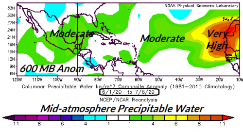
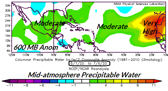
Research (AMS/Journal of Climate 2/15/18) has shown one of the key predictors of increased North Atlantic tropical cyclone activity since 1995 is the increased mid-atmospheric relative humidity at the onset of tropical cyclone season. Right now mid-atmospheric RH is buoyant in the Bahamas and especially the main development region for North Atlantic hurricanes to the east of the Caribbean Sea. Once the Saharan dust clouds fade (possibly beginning later this week) an uptick in deep tropics systems should emerge.
07/10/2020, 5:33 pm EDT

A Key Predictor of Seasonal Tropical Cyclone Activity

A key climate diagnostic identifying tropical cyclone potential across the tropical/subtropical North Atlantic basin at early onset of the season is the relative humidity or available moisture in the middle atmosphere. Above to much above normal available moisture, common during the past 25 years of seasonal uptick in North Atlantic activity signals above normal activity ahead. The early 2020 season available moisture is buoyant across the Gulf of Mexico and outer tropical basin signaling an active season ahead!