A Key Predictor of Seasonal Tropical Cyclone Activity
07/10/2020, 5:33 pm EDTModern-day La Nina Climatology for SEP/OCT Plus NOV/DEC
07/28/2020, 8:14 pm EDT

Fig. 1-2: The 5-day CAMS (model) forecast of African dust from the Sahara Desert identifies another dense wave moving westward in the central North Atlantic tropics. However, in 5 days the dust level lowers considerably.
Discussion: So far the tropical cyclone season has been very quiet in the deep tropics of the North Atlantic basin. The quiet nature is a surprise given a favorable Madden Julian oscillation (located over tropical Africa) and stronger-than-normal intra-tropical convergence zone. However, somewhat unique to early summer 2020 is evolution of convection-suppressing surge of waves of Sahara Desert dust clouds moving westward across the North Atlantic tropics. The latest wave of dense dust is located in the central North Atlantic tropics and surging westward (Fig. 1). By later this week the dust cloud reaches the Yucatan Peninsula and vicinity and weakens (Fig. 2). The central and eastern tropical North Atlantic are forecast to nearly lose the tendency for dust to extend westward from the Sahara signaling a possible pattern change enabling the tropics to become more active.
Learning point: Research (AMS/Journal of Climate 2/15/18) has shown one of the key predictors of increased North Atlantic tropical cyclone activity since 1995 is the increased mid-atmospheric relative humidity at the onset of tropical cyclone season. The increased mid-atmospheric moisture is attributed to the tendency for a warmer-than-normal ocean surface present the past 25 years. A warmer-than-normal ocean surface and above normal mid-atmospheric moisture enhances tropical cyclone development risk.
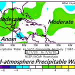
Pictured is precipitable water anomalies at 600 MB for the past 30 days which identifies moderate to very high moisture content in the Bahamas and especially in the outer tropical basin (Fig. 3). Implied is a generally very buoyant wet mid-atmosphere for tropical cyclone development in the main development region (MDR) for hurricanes located east of the Caribbean Sea and also in the Bahamas. Once the Saharan dust eases these regions should (more) easily generate a tropical cyclone.
As an interesting reference of abundant mid-atmosphere precipitable water/relative humidity the same 30-day period in 2005 identifies much above moisture content throughout the North Atlantic tropical/subtropical basin (Fig. 4). What followed was the busiest tropical cyclone season on record (28 tropical storms, 15 hurricanes and 7 intense hurricanes).

Fig. 3: The precipitable water/relative humidity in the middle atmosphere (600 MB) for the past 30 days across the North Atlantic basin.

Fig. 4: The precipitable water/relative humidity in the middle atmosphere (600 MB) for the same 30 day period in 2005 across the North Atlantic basin ahead of the most active tropical cyclone season on record.
Conclusion: The middle layers of the atmosphere in the tropical/subtropical North Atlantic basin are wet and supportive of tropical cyclone activity in the Bahamas and especially the MDR for North Atlantic hurricanes. Once the Saharan dust cloud regime fades which may begin later this week, tropical cyclones in the North Atlantic tropics will more easily generate.