
North America (wet) Monsoon Controlling U.S. Rainfall Pattern
06/26/2025, 5:39 am EDT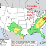
Excessive Rainfall/Flooding Mid-Atlantic Today
07/01/2025, 9:48 am EDT
Climate Impact Company Sunday Global AG Report
Global Weather/Climate Report
Issued: Sunday June 29, 2025
Highlights: AG traders/analysts understanding rainfall forecasts; Heat/dryness continues in Europe, expanding eastward.
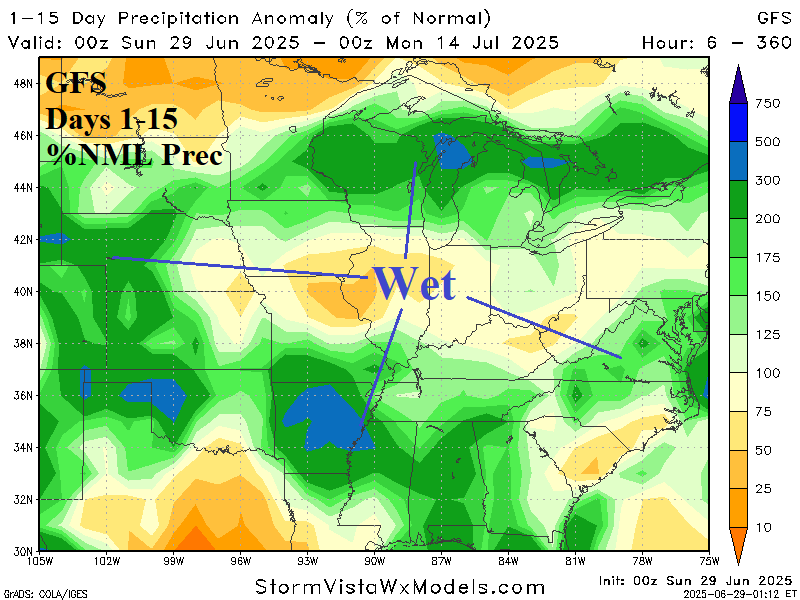
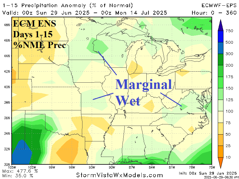
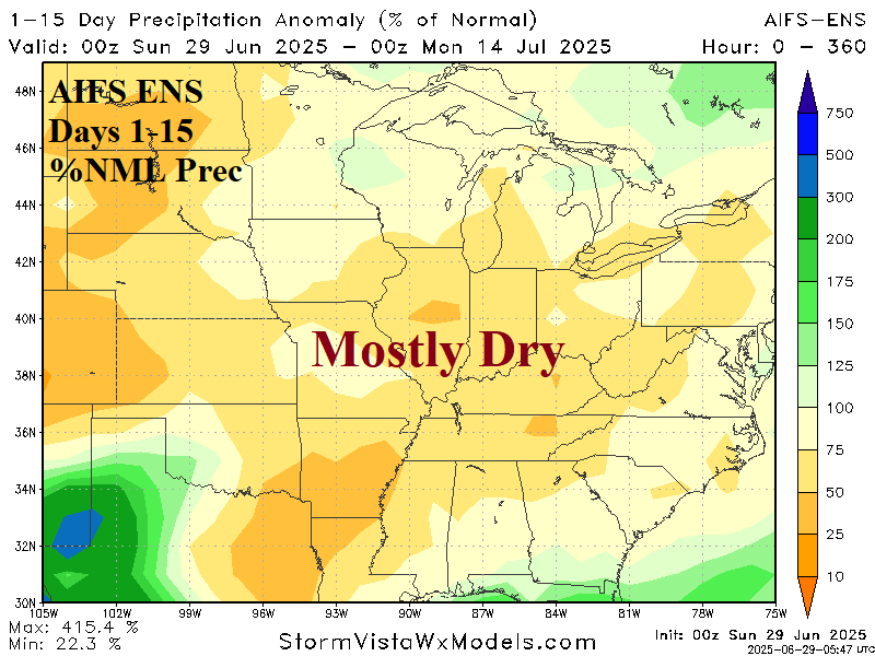

Fig. 1-4: The 15-day percent normal rainfall forecast by GFS, ECM ENS, and AIFS ENS. The ECM ENS 15-day temperature anomaly forecast is indicated.
Discussion: Typically, the GFS weighs heavily on agriculture markets mostly due to (traditionally) greater availability. The GFS is widely known as the most chaotic forecast model rendering lowest skill scores BUT can be the first at identifying pattern change. Despite the lower skill scores (precipitation and temperature) the GFS remains valuable to commodities markets. Note that the 15-day percent normal rainfall forecast across the U.S. AG Belt is quite wet in the Mid-south, western Great Plains, and Upper Midwest (Fig. 1). The ECM ENS is generally the best dynamic/physics-based operational model consistently showing near or top skill score. The 15-day percent normal rainfall forecast across the U.S. AG Belt is not nearly as wet as GFS offering only marginally wet weather in the Midwest States (Fig. 2). The AIFS ENS begins operational release around July 1st. The AIFS has trailed the Graph Cast skill scores on a consistent basis since release in 2023-24. The AIFS is upgraded to include an ensemble presentation and is available on a test basis now. The AIFS ENS indicates a dry 15-day forecast across the U.S. AG Belt (Fig. 3). Obviously, significant differences are indicated, and AG Traders/Analysts are likely to see larger differences in rainfall forecasts with the incorporation of new (AI) forecast processes. The Google Gen Cast AI model is not available to the public. Creators/marketers of that AI model claim the best performance.
To determine which forecast model is correct, a review of large-scale wet weather maker presence is addressed followed by recent skill scores. The new contributor to wet weather potential in the U.S. is early activation of the Southwest U.S. Monsoon. Wet weather in this source region is entrained into westerly flow aloft in the mid-latitudes to produce over-achieving thunderstorm regimes. Generally, this pattern is present through the next 2 weeks although less intense compared to forecasts last week as the northeast Gulf of Mexico becomes more tropically active. Skill scores of GFS/ECM rainfall forecasts are clearly too wet across the Midwest States during recent weeks. Consequently, based on largescale predictors and recent skill scores, the marginally wet ECM ENS is the best forecast. The ECM ENS 15-day temperature anomaly forecast is generally hotter than normal across the U.S. AG Belt (Fig. 4).
West and South Europe continues to observe dangerously hot and dry weather during early meteorological summer. The outlook for this week according to ECM ENS (Fig. 5-6) is steady oppressive heat and continued dryness for most of Europe (except northern areas). Drought conditions, river levels, are steadily worsening. In the 8-14-day period, valid for next week, the hot weather shifts eastward across the Black Sea region with strengthening dryness (Fig. 7-8).
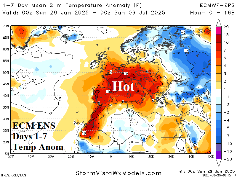

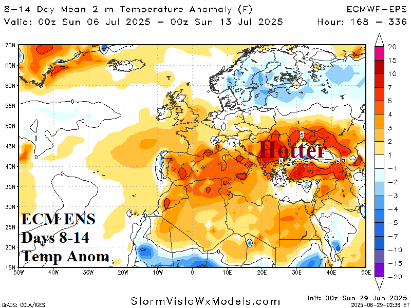

Fig. 5-8: ECM ENS 2-week temperature anomaly and percent of normal rainfall forecast for Europe/Western Russia.