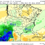
U.S. Week 2-4 Outlook: The National Pattern Cools Off and Turns Wetter
04/13/2026, 12:01 pm EDT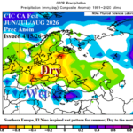
Major Drought for Europe During Summer 2026
04/15/2026, 12:54 pm EDT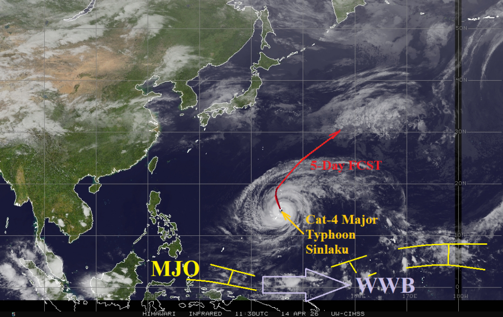

Climate Impact Company Tropical Feature
Issued: Tuesday April 14, 2026
Highlight: Unusual Early Season West Pacific Major Typhoon Sinlaku Indicates Potential for Busiest North Pacific TC Season on Record

Fig. 1: Weather satellite view of the West Pacific basin including early season Major Typhoon Sinlaku.
Discussion: A strong westerly wind burst (WWB) in the Pacific Ocean tropics between 140E and 160E also located across warm sea surface temperature anomalies (SSTA) and robust subsurface upper ocean heat helped spawn an early season unusually strong category-5 major typhoon (Sinlaku). The ingredients helping to ignite this early season intense storm to develop are shifting eastward and will ignite El Nino in May with rapid intensification likely to follow. The leaning easterly edge of the attendant subsurface (warm) Kelvin Wave is in the +6C to +7C (anomaly) range, possibly the strongest on record, and guarantees an intense El Nino episode for mid-to-late 2026. A strong El Nino in the East Pacific tropics supports abundant tropical cyclone activity. The strongest El Nino episodes on record (1982, 1997, and 2015) yielded above to much above tropical cyclone activity in the East Pacific including the second highest accumulated cyclone energy (ACE) index (288.9) on record. The range in East Pacific tropical cyclones for the strong El Nino years was 20-26, hurricanes 9-16, and intense hurricanes 5-11. Normal amount is 15 tropical cyclones, 8 hurricanes, and 4 intense hurricanes. This year, East Pacific tropical cyclones are likely to turn north toward Baja California and possibly California and reach Hawaii. Given the record strength of the Southeast Pacific marine heatwave (MHW), Mexico, Southwest U.S., and possibly Southern California should brace for major flooding rainfall events during the peak of tropical cyclone season. During the strong El Nino years the West Pacific was also very busy averaging 26-29 tropical cyclones, 19-23 hurricanes, and 12-16 intense hurricanes and included a whopping 571 ACE index in 1997. Given the potential scenarios identified, 2026 may be the most active tropical cyclone season on record for the North Pacific.
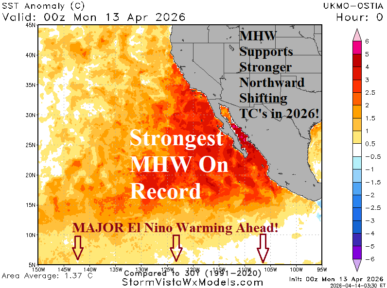
Fig. 2: A record strength marine heatwave in the Southeast Pacific sets the stage for tropical cyclones turning north during the 2026 season to last longer and with more intensity.