Cold Start to Week Midwest/Northeast U.S.; More Chill on the Way Late April/Early May
04/20/2026, 8:38 am EDT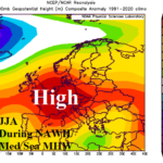
NAWH/Mediterranean Sea MHW Influence Supports Hit/Dry Europe Summer High-pressure Ridge
04/22/2026, 2:21 pm EDT
Climate Impact Company U.S. Month 1-4 Ahead Outlook
Issued: Tuesday, April 21, 2026
Highlight: Northwest record heat, possible strong Southwest Monsoon, wetter adjustments in the East.
Executive summary: The Climate Impact Company month 1-4 ahead climate outlook is updated. There are some changes from the earlier issued summer 2026 outlook and forecast confidence has increased as predictors are increasingly clear. High impact climate is likely and will affect public safety and market interests. Most prominent is the hot climate forecast for summertime across the West and Northwest U.S. with record heat possible the first half of summer in the Northwest and possibly late summer in California. An immense West U.S. drought extends to the Northwest States and intensifies. Conversely, fuel to ignite a potentially vigorous Southwest U.S. Monsoon is evident as the forecast shifts wetter. The East-central and gradually East U.S. trend wetter due to influence on climate of a warm western North Atlantic basin and large marine heatwave off southwestern North America. The Southern States are temperate while the Northeast gradually turns very warm and humid.
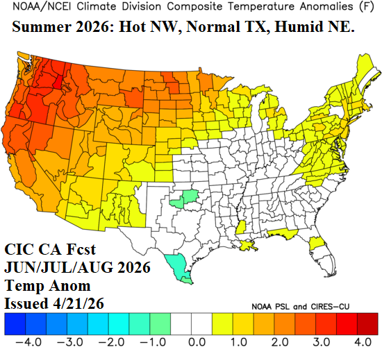
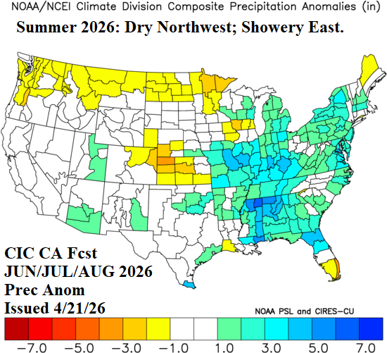
Fig. 1-2: The Climate Impact Company constructed analog JUN/JUL/AUG 2026 temperature and precipitation anomaly forecast.
Discussion: The Climate Impact Company month 1-4 ahead constructed analog climate forecast is based on 1.) ENSO; 2.) The Northeast Pacific marine heatwave; 3.) NOAA/CPC Seasonal Drought Outlook; and 4.) North Atlantic basin SSTA.
The ENSO outlook is a fortified strong El Nino ahead. The outlooks are confident due to the immense upper ocean heat in the equatorial Pacific Ocean. Australia Bureau of Meteorology relative Nino34 index forecasts indicate potential for the 2026 El Nino to surpass peak intensity of the 1983, 1997, and 2015 El Nino events late this year (Fig. 3). El Nino directly effects U.S. climate during the winter season and indirectly effects climate by alerting the monsoon regime during summer. A wetter effect by developing El Nino on the Southern U.S. States is expected during mid-to-late 2026 warm season.
The marine heatwave (MHW) off the Southwest Coast of North America is record strength in both magnitude and aerial coverage (Fig. 4) and will continue through the summer season. MHW NEP25A is different from the “warm blob” of 2015 due to southward displacement. The added low-level moisture to the atmosphere associated with the anomalous warm ocean could ignite an unusually strong Mexico/Southwest U.S. Wet Monsoon during mid-to-late summer.
The NOAA/CPC Seasonal Drought Outlook provides clues of high impact climate for early-to-middle summer 2026. As El Nino develops and combined with the MHW influence, a tendency for wet southern latitude climate develops and eliminates Gulf States drought (Fig. 5). This process may include the Southwest U.S. especially after July. Drought will expand into the Northwest U.S. The Western drought guarantees a hot summer likely to extend into Southwest Canada.
The North Atlantic basin features anomalous warmth in the subtropics likely to expand during the summer season (Fig. 6). Anomalous warmth is likely in the Gulf of Mexico with marginal warmth in the Caribbean Sea. In 2026, the main development region (MDR) for hurricane development in the central/eastern tropics is likely to stay near normal. The North Atlantic warm hole (NAWH) pattern south of Greenland is stronger than normal this season. The western North Atlantic is generally warmer than normal and gradually supports a wetter regime in the East U.S. for the warm season, especially the second half of summer.
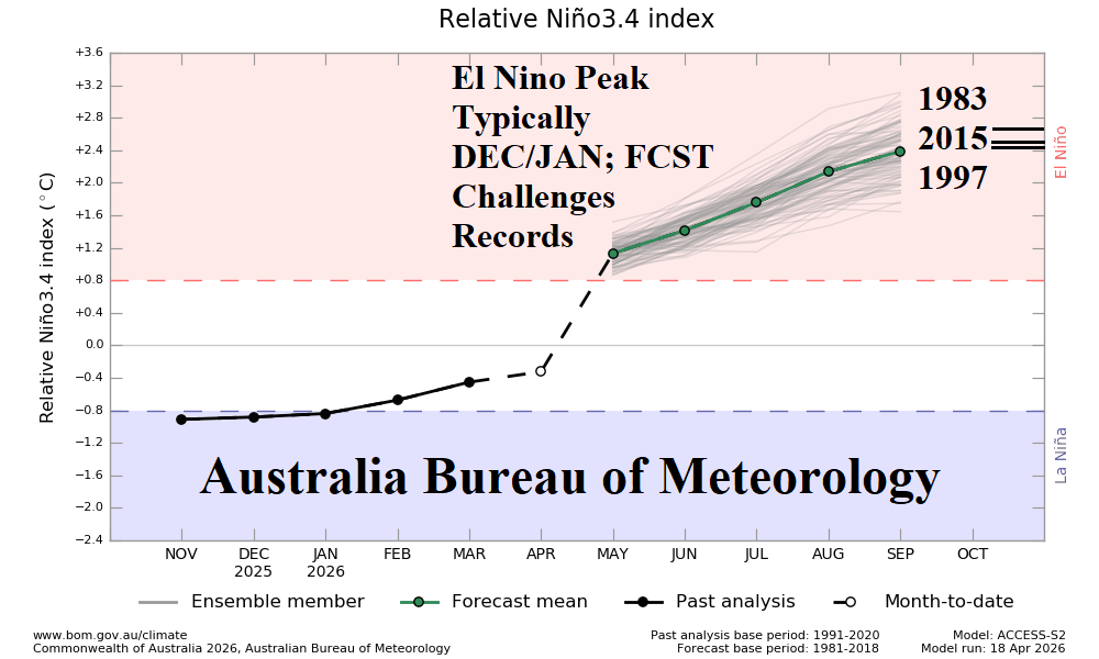
Fig. 3: Australia Bureau of Meteorology relative Nino34 SSTA forecast reveals El Nino intensity for later this year rivaling the strongest El Nino’s on record.
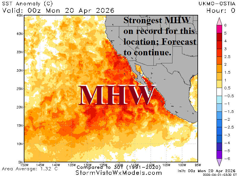
Fig. 4: The record strength marine heatwave off the California Coast and southwestward and including either side of Baja California.
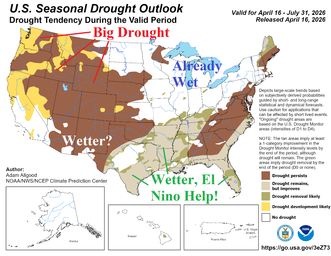
Fig. 5: NOAA/CPC Seasonal Drought Outlook valid through July 31, 2026.
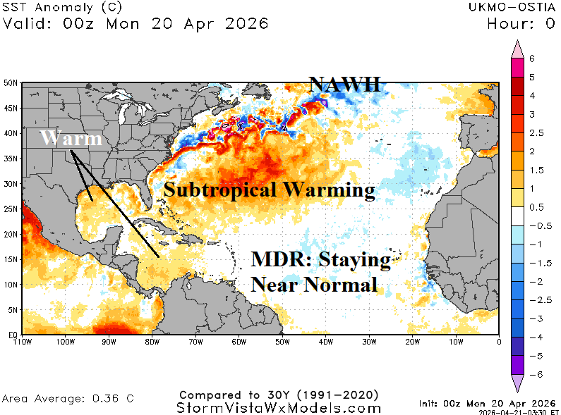
Fig. 6: Daily SSTA analysis of the North Atlantic Basin with annotated projections for the summer season.
May 2026 outlook: ECM “weeklies” show a wet/cool start to May, and the constructed analog extends that projection well into May. Later in the month, the Northeast turns warmer. Warm risk is also evident in the Northwest States, strongest during the last third of the month. The constructed analog is very consistent with heavy rain potential in Texas. Operational models are generally wet but without indicating super heavy rainfall. The constructed analog suggests a wet surprise for Texas during May. The outlook also indicates wet weather for south/southwest Great Plains drought concern.
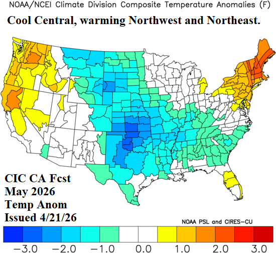
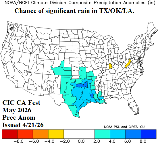
Fig. 7-8: The Climate Impact Company constructed analog May 2026 temperature and precipitation anomaly forecast.
June 2026 outlook: The constructed analog projects a high amplitude high pressure ridge over the Northwest U.S. during June. The pattern is likely to become semi-permanent during the last half of the month. The upper ridge combined with strengthening drought supports possible record warmth, especially in the Northwest U.S. gradually extending into Southwest Canada to melt lingering historic mountain snows in that sector. Extreme heat risk also implicates California and the Southwest U.S. prior to the onset of the wet monsoon. Dryness extends from the Northwest to the Upper Midwest and central Great Plains. However, the Midwest wet bias (associated with an El Nino climate) continues. The East and South are normally warm in June with “sneaky” hot weather possible in the Mid-Atlantic States.

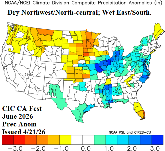
Fig. 9-10: The Climate Impact Company constructed analog June 2026 temperature and precipitation anomaly forecast.
July 2026 outlook: Mid-summer is adjusted wetter. The culprit is an anticipated wet Southwest U.S. Monsoon, possibly wetter than indicated. Moisture from this feature is swept northeastward to soak the Midwest States during July. Drier climate is northwest of the wet regime, across the North-central/Upper Midwest States. However, the southern Great Plains receive beneficial rainfall. Hot weather is likely to continue on the West Coast, Northwest U.S., and into Southwest Canada. “Sneaky” hot weather is possible in the northwestern Gulf States and Mid-Atlantic.
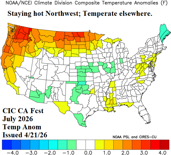
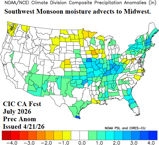
Fig. 11-12: The Climate Impact Company July 2026 temperature/precipitation anomaly outlook utilizes CFS V2 “monthlies” as the “best” forecast.
August 2026 outlook: Late summer brings ample anomalous heat to California, the Southwest U.S., and the Northeast Corridor. Unusually high humidity accompanies much of the anomalous heat. The Missouri Valley is cooler than normal due to a semi-permanent upper trough linked to wet soils. The Southeast turns wet with convective rainfall. To compensate for the convection, subsidence dries out the central and southern Great Plains.
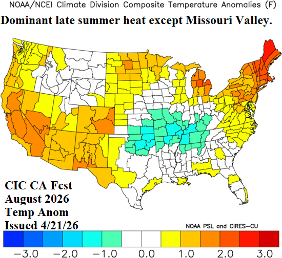
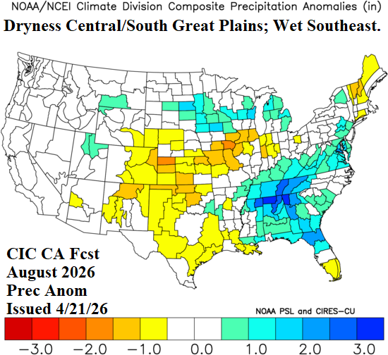
Fig. 13-14: The Climate Impact Company constructed analog August 2026 temperature and precipitation anomaly forecast.