MJO Activates; El Nino Climate to Develop. Cooler East U.S. Extended-range Possible
05/31/2026, 1:44 pm EDT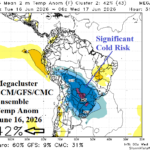
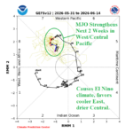
South America Cold Weather Threat Mid-June
06/03/2026, 1:47 pm EDT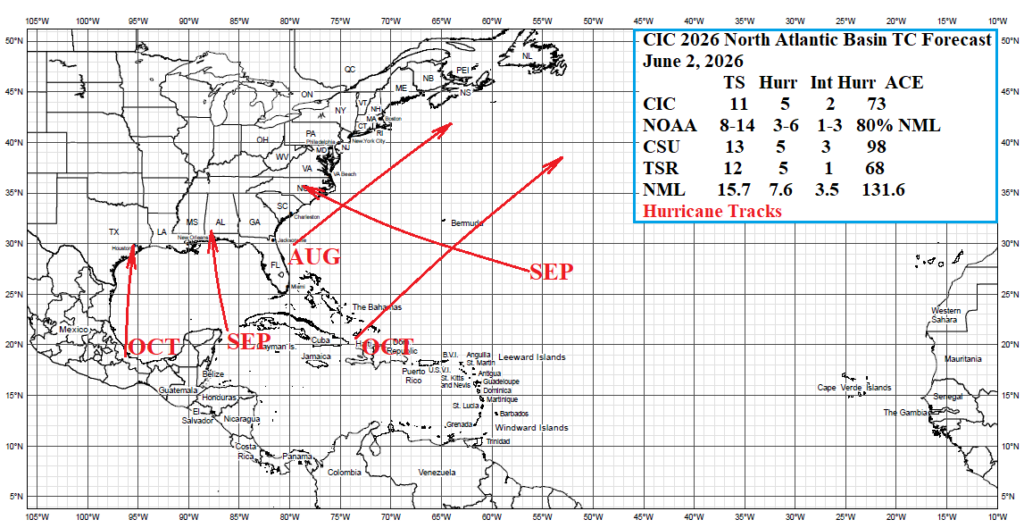
![]()
Climate Impact Company 2026 North Atlantic Basin
Tropical Cyclone Outlook
Issued: Tuesday June 2, 2026
Highlight: The seasonal activity lowers but the danger to the U.S. Coast increases.
Executive summary: The updated Climate Impact Company 2026 North Atlantic basin tropical cyclone season activity forecast lowers amount previously indicated in early April from 13 to 11 tropical storms while maintaining 5 hurricanes and lowering from 3 to 2 the amounts of intense hurricanes. The accumulated cyclone energy forecast lowers sharply from 98 to 73. However, the projected hurricane tracks indicate two potential land-falling systems in the Gulf of Mexico and another into the North Carolina Coast. The seasonal activity lowers but the danger to the U.S. Coast increases.

Fig. 1: The Climate Impact Company 2026 North Atlantic basin seasonal tropical cyclone activity forecast and projected hurricane tracks.
Climate discussion: As of late May, an El Nino climate is developing rapidly as implied by southern oscillation index (Fig. 2). The conventional Nino34 SSTA reveals a robust El Nino presence while relative-Nino34 SSTA is barely within the El Nino threshold (Fig. 3). MAY-26 upper ocean heat remains immense (Fig. 4) although less intense than APR-26 (Fig. 4). Relative-Nino34 SSTA forecasts by NOAA and the Australia Bureau of Meteorology continue to indicate a potential record-strength El Nino by late tropical cyclone season (Fig. 5-6). The North Atlantic basin SSTA is +0.36C (Fig. 7) which is near the 80th percentile (80% of years are cooler) given the 30-year climatology. However, the North Atlantic SSTA is comparatively cooler for late May to recent years. The main development region (MDR) for North Atlantic hurricanes has cooled to below normal during late May. The upper ocean heat across the length of the tropical North Atlantic has recently shifted to cooler than normal and the 4th coolest since 2013 (Fig. 8). The International Research Institute (IRI) for Climate and Society AUG/SEP/OCT probabilistic rainfall forecast for Africa indicates tropical Africa is very wet on the Indian Ocean side and less certain on the Atlantic side. Implied are normal-strength tropical waves entering the eastern tropical North Atlantic basin during the peak of tropical cyclone season. The quasi-biennial oscillation (QBO) is shifting out of negative phase and positive phase should develop during late tropical season. +QBO offers a favorable deep tropics environment for tropical cyclone generation due to increased ventilation in the upper troposphere. The Southeast Pacific is unusually warm (Fig. 9) and should enhance the East Pacific 2026, tropical cyclone season. Usually, this circumstance diminishes risk in the West Atlantic tropics. However, in 2026, due to unusually warm waters south of Mexico there is risk of an unusual cross-Mexico trek of an East Pacific tropical cyclone moving into the Western Gulf of Mexico.
| Enhanced Activity | Neutral Influence | Suppressed Activity | |
| ENSO | X | ||
| Deep Tropics SSTA | X | ||
| Subtropics SSTA | X | ||
| Upper Ocean Heat | X | ||
| West Africa Rain | X | X | |
| QBO | X | ||
| East Pacific SSTA | X (Gulf) | X |
Table 1: Predictors used for the Climate Impact Company 2026 North Atlantic basin seasonal tropical cyclone season forecast.
Climate summary: A strong El Nino is predicted for the tropical cyclone season. The still intense but diminishing upper ocean heat suggests the El Nino episode may not be as intense as forecast models indicate. However, El Nino is a strong negating factor on seasonal activity in the North Atlantic basin in 2026 due to the evolving westerly upper shear pattern (Table 1). The North Atlantic basin is normally warm in the deep tropics by late summer and warmer than normal in the subtropics including the Gulf of Mexico. In 2026, North Atlantic tropical cyclones are slightly more likely to reach peak intensity outside the tropics where upper ocean and ocean surface warming is highest. Potent tropical waves moving off the West Africa Coast into the eastern North Atlantic tropics this year are not likely. The QBO is changing phase during the tropical cyclone season and is not likely a major influencer on tropical cyclone activity. The very warm Southeast Pacific Ocean increases the risk of an unusual cross-Mexico trek of an East Pacific tropical cyclone into the Gulf of Mexico where a regenerating storm would occur. IRI/LDEO forecasts a wetter climate across the Sahara for AUG/SEP/OCT lowering risk of intrusive dust from the Sahara to inhibit tropical cyclone activity. However, prior to this time periods of inhibiting dust are possible.
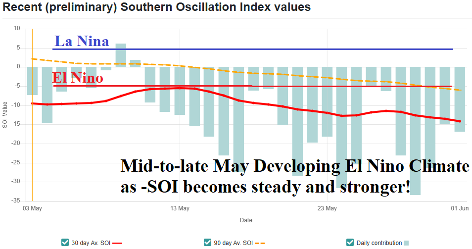
Fig. 2: Strengthening southern oscillation index indicates an El Nino climate is developing.
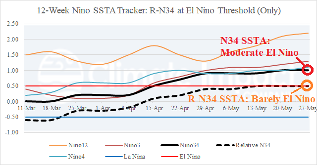
Fig. 3: The NEW Relative Nino34 SSTA index is at the El Nino threshold while conventional Nino SSTA observations are in the moderate-to-strong El Nino category.
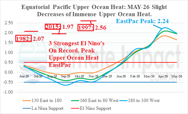
Fig. 4: Upper ocean heat for El Nino 2026 is the second strongest on record in April, weakening slightly in May.
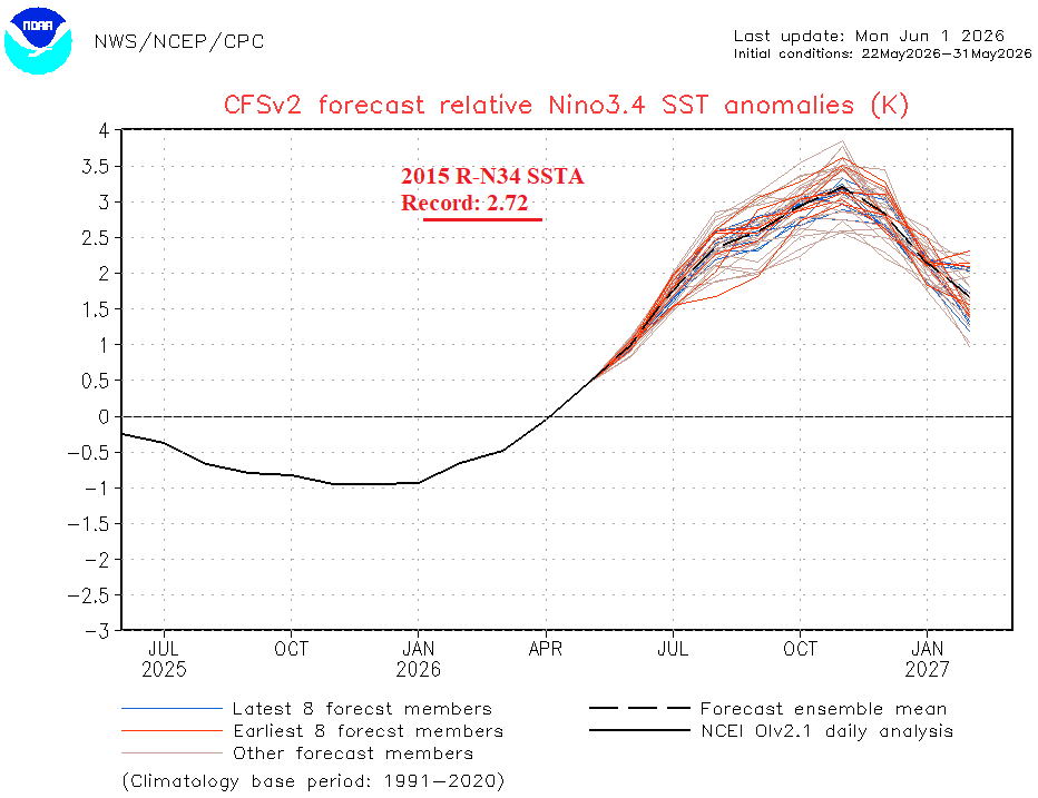
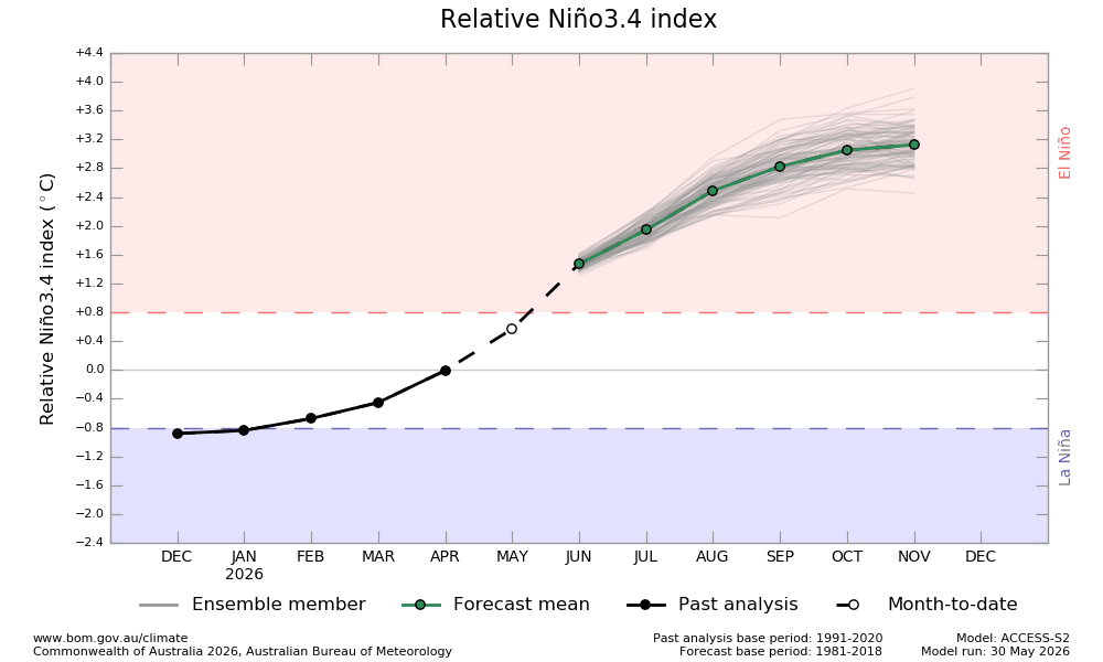
Fig. 5-6: The NCEP/CFS V2 and POAMA RN34 SSTA forecast each indicate a record warm N34 SSTA during Q4/2026.
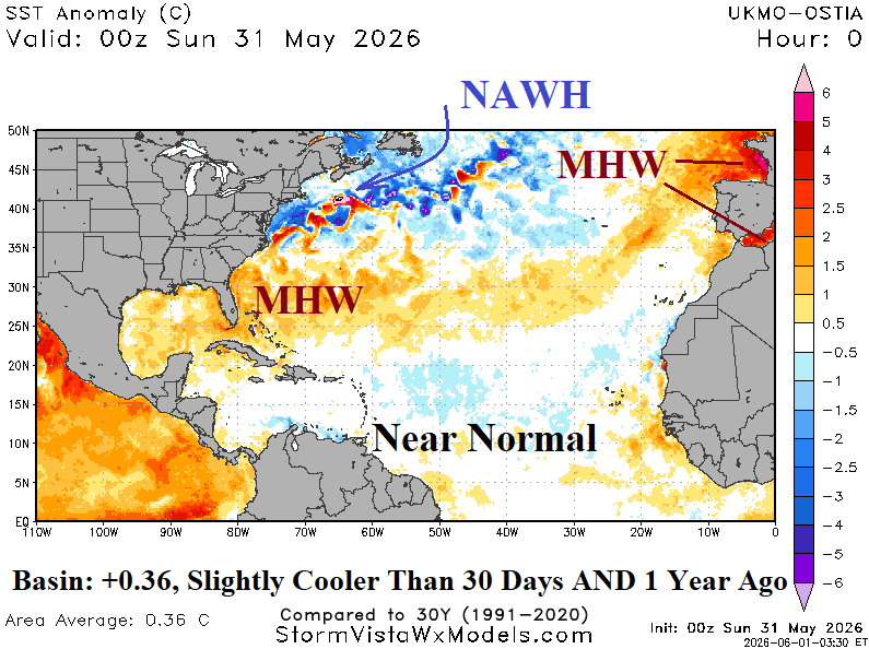
Fig. 7: The North Atlantic basin is marginally warmer than normal mostly due to marine heatwaves in the Bahamas and northeast basin.
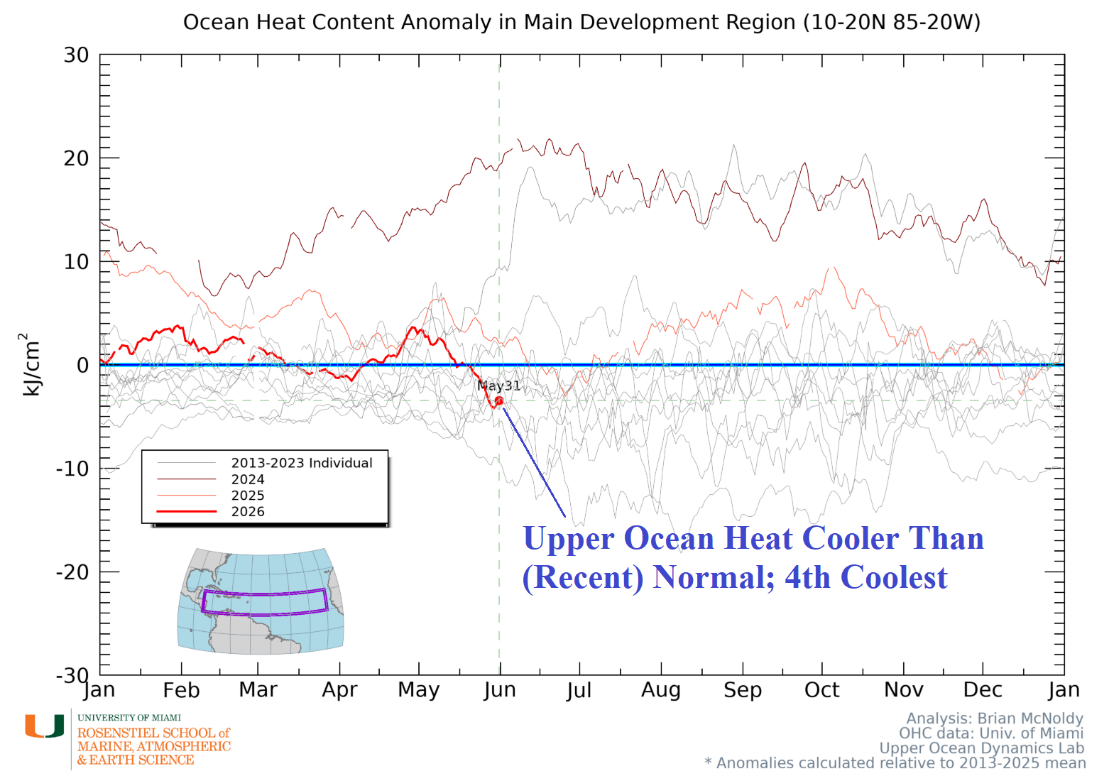
Fig. 8: Upper ocean heat across the tropical North Atlantic basin is cooler than the 2013-25 normal.
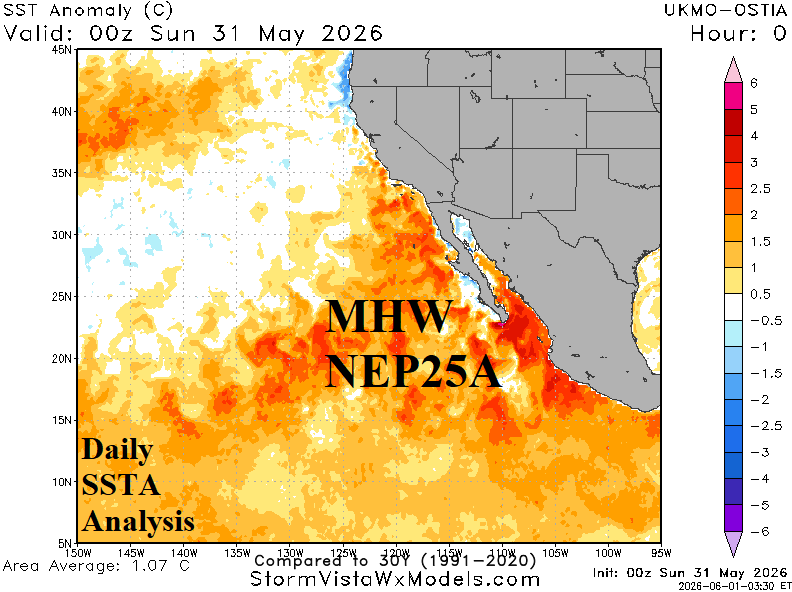
Fig. 9: Southeast Pacific daily SSTA analysis reveals a record warm surface due to the expansive Maine Heatwave NEP25A.
Analog years: The strong upper ocean heat present in the equatorial East Pacific is supportive of the potential record-strength El Nino forecasts later in 2026. Consequently, the analog forecast considers the top 2 upper ocean heat record years taken from the accelerating warm global oceans period of the past 30 years: 1997 and 2015. Due to similarities of 2015 to 2026 when the “warm blob” was in the Northeast Pacific, 2015 weights twice in the analog. Additionally, the North Atlantic warm hole (NAWH) forecast is unusually strong during the 2026 tropical cyclone season and similar with 2015 and 2018. Therefore, 2015 is weighted a 3rd time, and 2018 is added.
Activity forecast discussion: The Climate Impact Company 2026 North Atlantic basin seasonal tropical cyclone activity forecast is reduced from the original outlook issued in early April. The updated forecast is 11 tropical storms, 5 hurricanes and 2 intense hurricanes and an accumulated cyclone energy (ACE) index forecast of 73 (Table 2). Based on ACE index, the forecast is the least active season since the 2015 El Nino year. The activity forecast is markedly below normal (Table 3).
| Year | Weight | Tropical Storms | Hurricanes | Major Hurricanes | ACE Index |
| 2018 | 1 | 15 | 8 | 2 | 133 |
| 2015 | 3 | 11 | 4 | 2 | 63 |
| 1997 | 1 | 8 | 3 | 1 | 41 |
| Average | 11.2 | 4.6 | 1.8 | 72.6 | |
| Forecast | 11 | 5 | 2 | 73 | |
| Previous | 13 | 5 | 3 | 98 |
Table 2: The analog years and their weighting used to generate the Climate Impact Company 2026 North Atlantic basin seasonal tropical cyclone season forecast.
| Tropical Storms | Hurricanes | Major Hurricanes | ACE Index | |
| 2026 Forecast | 11 | 5 | 2 | 73 |
| Previous | 13 | 5 | 3 | 98 |
| 50-Year NML | 13.3 | 6.7 | 2.8 | 110.0 |
| 30-Year NML | 15.7 | 7.6 | 3.5 | 131.6 |
| 10-Year NML | 18.2 | 8.2 | 3.9 | 149.3 |
| El Nino | 8-10 | 4-6 | 1-2 | 65-80 |
Table 3: The Climate Impact Company 2026 North Atlantic basin tropical cyclone season activity forecast compared to various climatology.
Development areas/tracks discussion: Research has shown that tropical cyclone tracks leave a trail of high relative humidity (RH) at 600 MB (middle troposphere). Therefore, taking the constructed analog years to project the most likely high RH regions and determine where the seasons strongest storm tracks are most likely is reasonable. The constructed analog is markedly dry across the deep tropics and most of the subtropics during July and August (Fig. 10-11). Implied is low risk of significant tropical cyclone activity. An early season hurricane is possible in July east of Florida but more likely in August off the East Coast. Due to El Nino, the deep tropics are markedly dry in September and October (Fig. 12-13). However, streaks of high RH in the subtropics suggest that 4 of this year’s 5 hurricanes occur at or after the climatological peak activity. Included are 2 potential important tropical systems in September making landfall in the Gulf States and Carolina Coast and unusual late season intense tropical system in the western Gulf of Mexico.
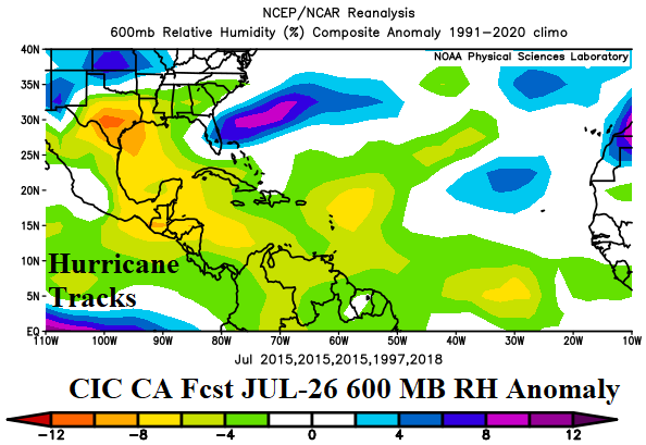
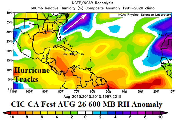
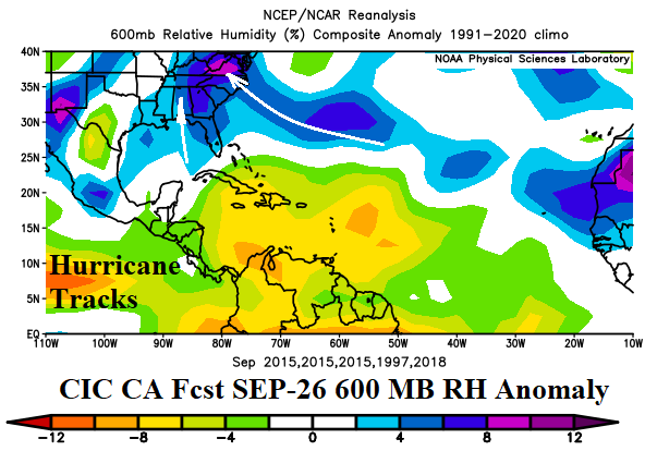
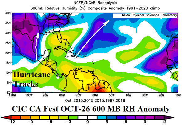
Fig. 10-13: The Climate Impact Company constructed analog forecast for 600 MB relative humidity anomalies to identify tropical cyclone formation areas and potential hurricane tracks for July through October 2026.