06/30/2026, 6:01 am EDT

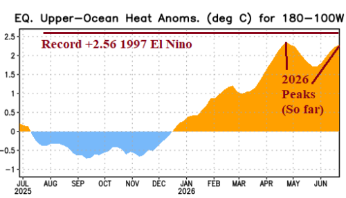
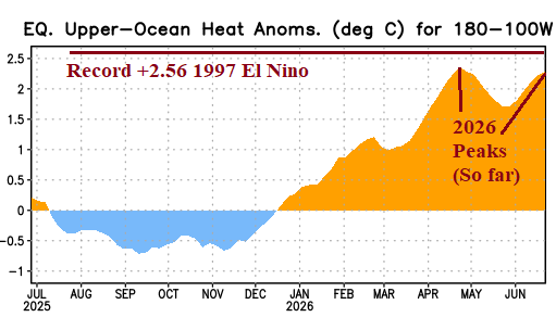
Near Strong Oceanic El Nino Threshold

Upper ocean heat has reached a second peak and will approach the all-time record in July previously produced during the 1997 El Nino. The reaction is oceanic El Nino warming reaching strong intensity with atmospheric El Nino (also) intensifying rapidly.
06/30/2026, 4:51 am EDT

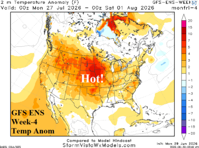
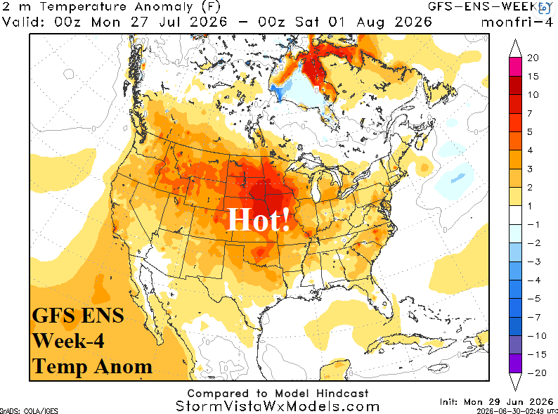
Plenty Of Impactful Heat Across U.S. In Latest Week 2-4 Forecast

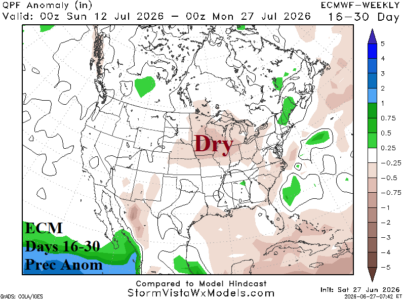
The week-3 forecasts are cooler in the East according to most AI models and with weak MJO phase_7 and moderate -NAO there is some support for that projection. HOWEVER, during mid-summer with a vast hot air source region formed during June across the Southwest U.S., the AIFS and ECM Ensembles combine to emphasize the Southwest U.S. high pressure system entering week-3 muting an East Coast trough. CIC is siding with more impactful heat for week-3/week-4 forecasts including the Great Plains week-4.
06/29/2026, 4:47 am EDT

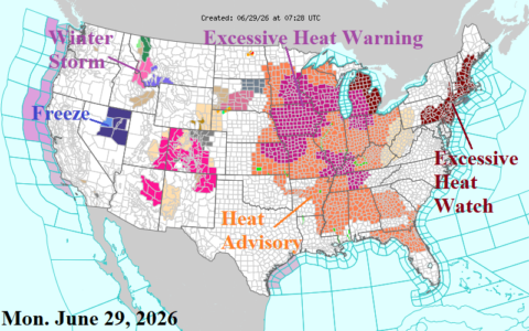
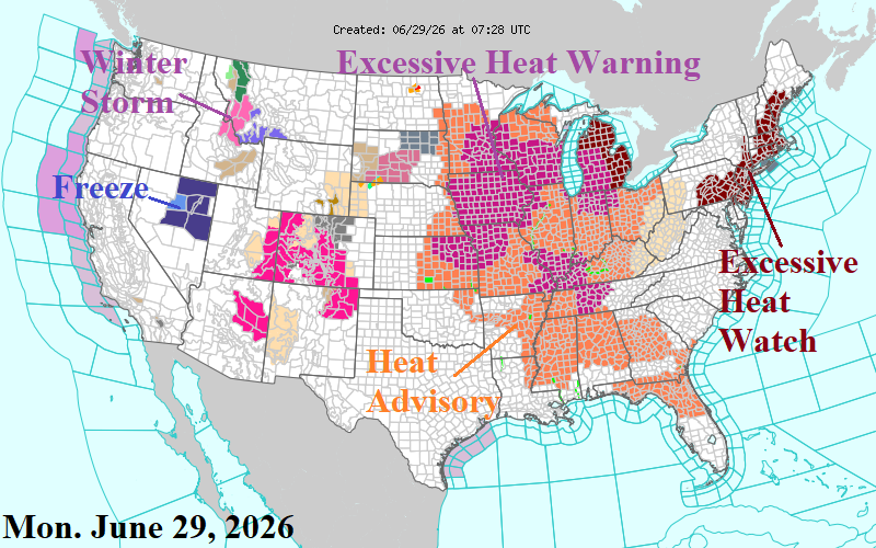
Searing U.S. Heatwave Emerging, Expands This Week

Excessive Heat Warning and Watch areas plus Heat Advisories are expanding as the heatwave of late June/early July continues to develop/expand. Key elements of this heatwave are certainly the afternoon temperatures but adding high dew points, therefore dangerous heat index and warm nights which limit recovery for electric grid systems, a problem that accelerates over a few days and certainly evident across much of PJM, especially PJM-East this week.
06/29/2026, 4:44 am EDT

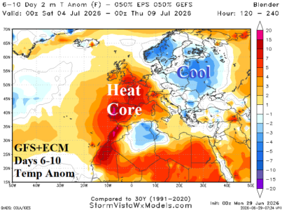
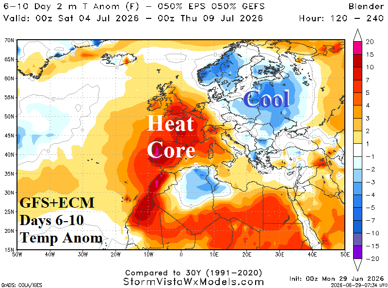
Worse-case Scenario for Europe as Southwest Europe Heat Regenerates, Pounces on France in Medium range

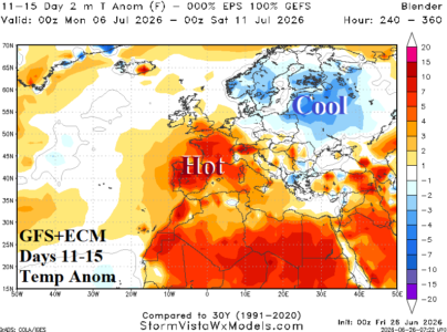
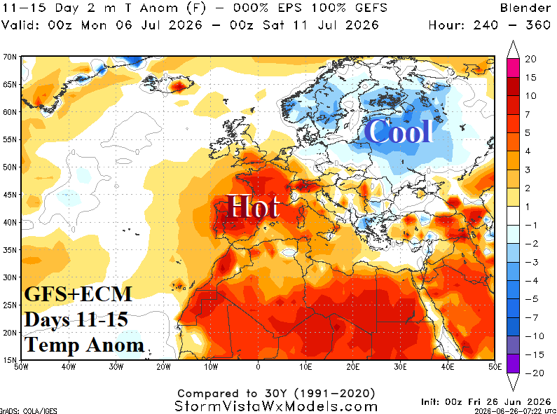
In Europe, a worse-case scenario is unfolding. The late June heatwave core has shifted across Eastern Europe this week while beginning to regenerate in Southwest Europe/Northwest Africa (Fig. 2). In the medium range, combining GFS and ECM, the Southwest Europe heat expands and intensifies reaching U.K. days 6-10 and continues to expand eastward in the 11-15-day forecast. The hottest weather within this new heatwave expansion is across France.
06/28/2026, 10:15 am EDT

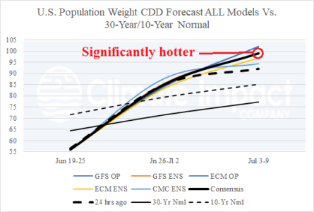
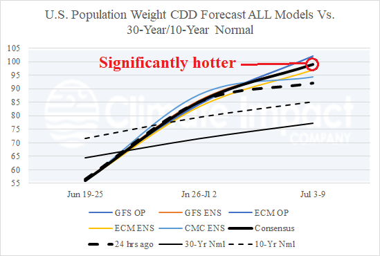
Hottest Week in U.S. of Past 10 Years: July 3-9, 2026

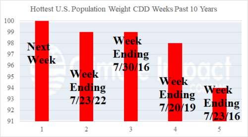
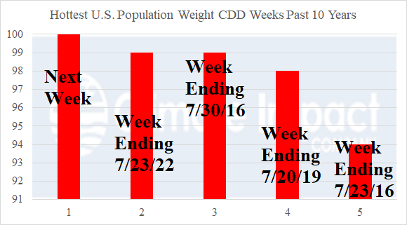
The consensus of all operational models and their U.S. population weight CDD projected for the week ending July 9, 2026, is 100 CDD which would eclipse the previous hottest week of the last 10 years at 99 CDD recorded for the week ending July 23, 2022, and July 30, 2016.
06/26/2026, 9:53 am EDT

Europe Heat Fades in Medium-range (Except Southwest Europe)

The Europe heatwave remains intense and widens into the weekend followed by cooler changes for the northern half of Europe in the 6-10-day period. In the 11-15-day period, GFS and ECM (equally) combine to produce a cooler Northwest Eurasia forecast while Southwest Europe stays hot.
06/26/2026, 9:50 am EDT

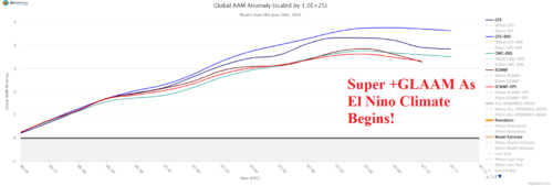
El Nino Climate Arrives/Intensifies Thanks to +GLAAM Forecast

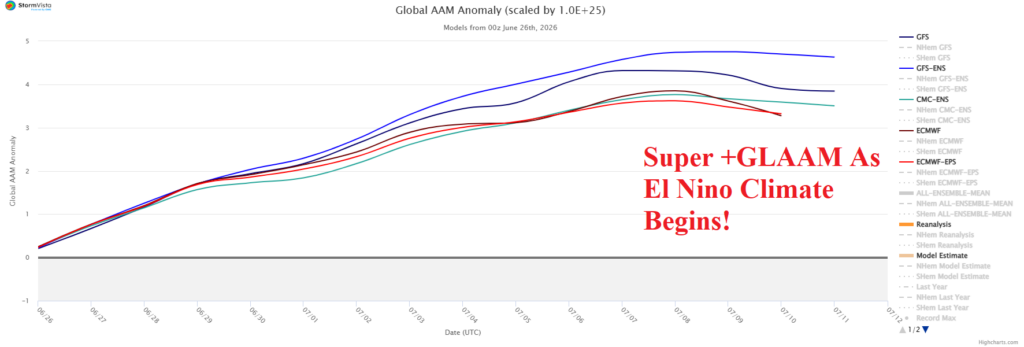
Increased westerly wind in the middle latitudes is characteristic of an El Nino climate, particularly during the winter season. Increased westerlies in the middle latitude is well represented by positive phase of global atmospheric angular momentum (GLAAM) index.
06/25/2026, 1:55 pm EDT

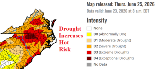
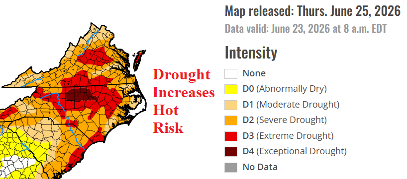
Mid-Atlantic Drought is a Worry! Influence on Excessive Heat Risk for Mid-Summer!

Severe drought in the Mid-Atlantic region is a significant concern as July approaches. The risk of over-achieving heat is significantly elevated across a large drought area during July. The hot bias provided by extreme dry soil moisture can easily overwhelm synoptic level forecasts and that’s the concern in July for the Mid-Atlantic region. The 12Z GFS Mid-Atlantic heat is hard to ignore.
06/25/2026, 8:00 am EDT

Climbing Cooling Degree Days for Early July in U.S.

The U.S. population weight CDD forecast has shifted significantly hotter for the week ending July 9th. The consensus is near 100 CDD, almost 15 CDD warmer than the 10-year normal.
06/25/2026, 7:58 am EDT

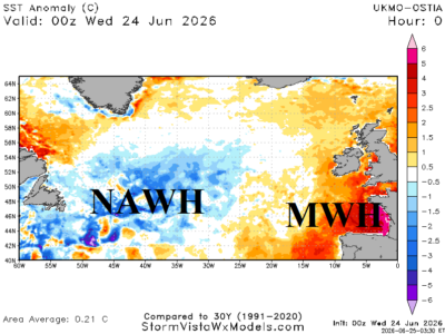
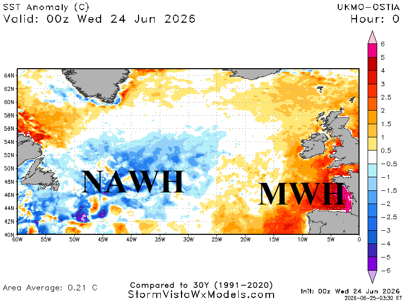
North Atlantic Warm Hole Correlated With Europe Heat Risk; Expect Repeat in July and August

The North Atlantic warm hole (NAWH) is vividly displayed in daily sea surface temperature anomalies (SSTA) analysis centered south of Greenland and extending southwestward while compensating marine heatwaves (MHW) are present off the Europe West Coast, record warm in the Mediterranean Sea, with additional MHW’s in the Norwegian Sea and North Sea to Baltic Sea. The SSTA regime described is semi-permanent since 2015 and well-correlated to the tendency for amplified upper-level high pressure ridge areas during summertime.
06/24/2026, 9:06 am EDT

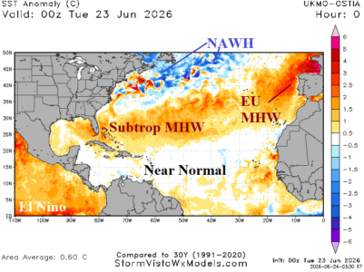
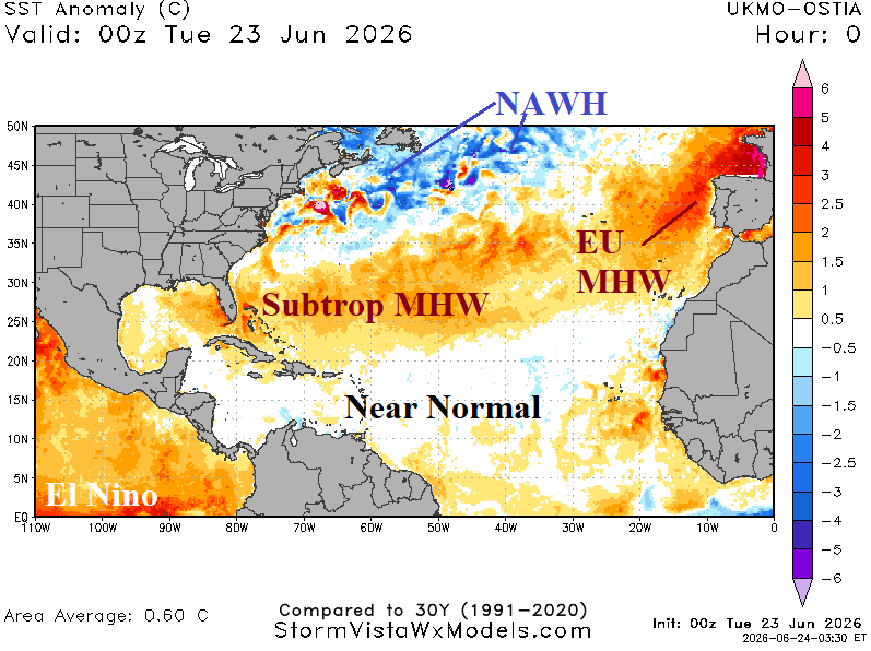
Check On North Atlantic Basin SSTA Pattern

The daily North Atlantic basin SSTA analysis is mixed with a large subtropical marine heatwave (MHW) east of Florida and a large North Atlantic warm hole (NAWH) south of Greenland extending southwestward to the Northeast Coast.