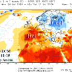
Europe Heat Fades in Medium-range (Except Southwest Europe)
06/26/2026, 9:53 am EDT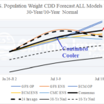
Extended-range CDD Forecasts Shift Hotter
07/02/2026, 8:16 am EDT
Climate Impact Company Early U.S. Notes
Highlight: Searing heatwave emerging and will expand this week.
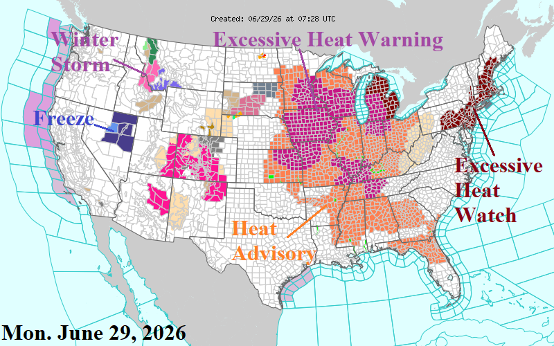
Fig. 1: NOAA/NWS weather watch, warnings, and advisories.
Discussion: Excessive Heat Warning and Watch areas plus Heat Advisories are expanding as the heatwave of late June/early July continues to develop/expand (Fig. 1). Key elements of this heatwave are certainly the afternoon temperatures but adding high dew points, therefore dangerous heat index and warm nights which limit recovery for electric grid systems, a problem that accelerates over a few days and certainly evident across much of PJM, especially PJM-East this week. Chicago reaches the upper 90’s with heat index 107 July 2-3, Washington, DC passes 100F July 2-3 with heat index approaching 110F. Atlanta could reach the upper 90’s later this week. A cold front to end the heatwave does not emerge to end the heatwave except for New England late next weekend. Instead, the air mass becomes thundery and wet weather risk suppresses daytime heat but maintains high humidity the 4th of July weekend. Severe storms are persistent this week on the back edge of the heatwave across the Upper Midwest to Nebraska.
The U.S. population weight CDD forecast lowers slightly for next week and the following week (Fig. 2). If so, next week would trail the hottest weeks of July (week ending 7/23/22 and 7/30/16) when 99 CDD were record (by NOAA) with about 98 CDD. Although less extreme, the July 10-16 value remains quite hot.
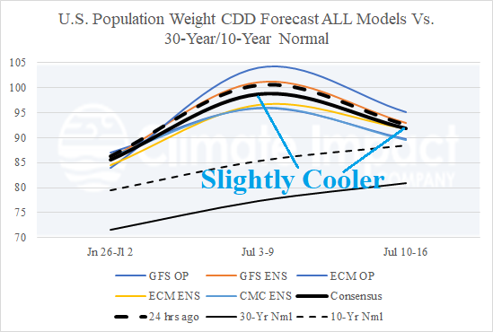
Fig. 2: The U.S. population weight CDD forecast for the U.S. utilizing all models, their consensus, and comparison with 24 hours ago and the 10-year/30-year climatology.