11/30/2025, 2:15 pm EST
A graph of different colored lines AI-generated content may be incorrect.

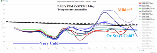
Snow Cover Bias Supports Cold PJM Forecast

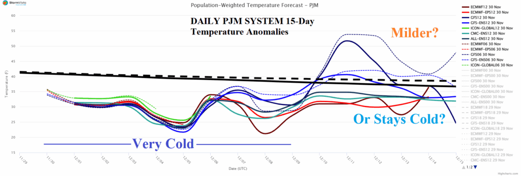
The building Midwest and Interior Northeast/Mid-Atlantic snow cover this week helps to enhance the cold pattern in place for PJM the next 10 days which may moderate in the 11-15-day period or possibly turn warmer than normal.
11/30/2025, 9:34 am EST
A map of the continent with different colors AI-generated content may be incorrect.

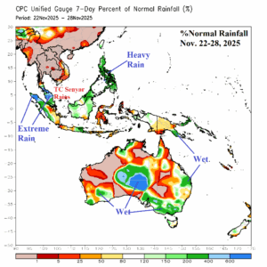
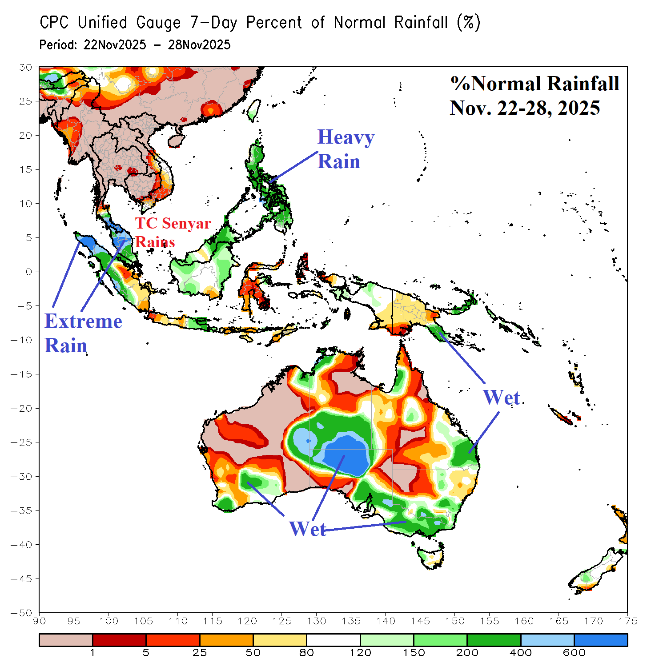
Stalled MJO in November Responsible for Late Season Tropical Cyclones Senyar and Ditwah Flooding Western Indonesia/Southern India

Building convection centered over the eastern tropical Indian Ocean and Maritime Continent initiated in early November, strengthened mid-November, and reached peak intensity during late November. During peak intensity, 2 unusually late season tropical cyclones formed including Senyar striking Western Indonesia and Ditmar moving into Southern India. Extreme rains caused historic flooding and mudslides killing 100’s in Western Indonesia with similar damage and fatalities confined to Southern India.
11/28/2025, 6:20 am EST
A map of the united states with snow AI-generated content may be incorrect.

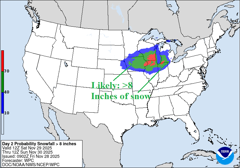
Early Season Chicago Snowstorm

A substantial part of the Northern U.S. is affected by a combination of winter storm warnings and watch areas including Lake-effect Snow Warnings valid for today and tomorrow. Jackpot snowfall amounts stretch from North Dakota to Iowa today/tonight (4-6 inches) increasing to 6-14 inches Iowa to Indiana (and centered on Chicago) tomorrow.
11/28/2025, 5:25 am EST
A map of the weather AI-generated content may be incorrect.

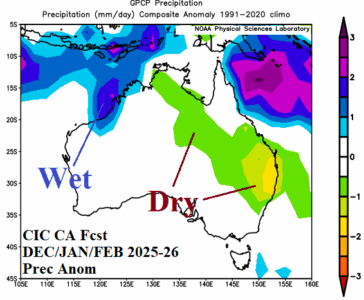
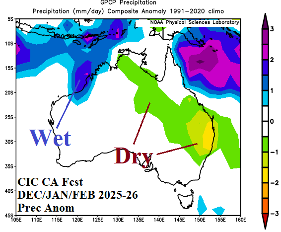
Surprising Drier Change Eastern Australia Latest Summer 2025-26 Outlook

The latest Climate Impact Company constructed analog climate forecast for meteorological summer 2025-26 has changed. The outlook is drier across East Australia and hotter across Southeast/South-central Australia. The anomalous heat and dryness in this region indicate expanding drought is likely.
11/26/2025, 8:39 am EST
A graph of a cold and heavy weather AI-generated content may be incorrect.

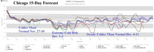
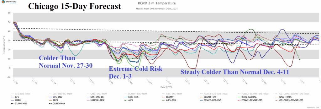
The U.S. Cold Pattern Arrives and Settles on Chicago!

In Chicago, colder weather arrives to end November. However, peak intensity of cold settles on Chicago next week. In the extended range, the chill modifies but continues toward mid-December. Snow is on the ground to sustain the cold.
11/25/2025, 5:42 am EST
A graph of different colored lines AI-generated content may be incorrect.

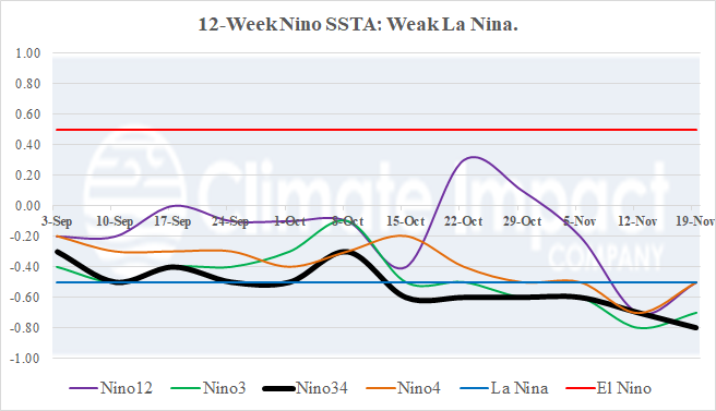
Weak La Nina Continues

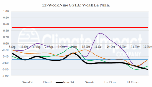
During November, La Nina is weak but established with both oceanic and atmospheric characteristics. The Nino34 SSTA cools to -0.8C, the strongest (cool) signature of this episode. The southern oscillation index shifted to (mostly) strong positive phase during November, indicating a La Nina atmosphere has formed. The subsurface cool fuel to maintain La Nina is weak-to-moderate and slightly less cool during the past 1-2 weeks.
11/25/2025, 5:40 am EST
A map of the world AI-generated content may be incorrect.

Hotter/Drier Regime Emerges Gradually in December for Australia

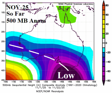
November has been cooler than normal across much of Australia due to a semi-permanent upper trough centered southeast of Australia. The upper trough remains in place well through DEC-25. The upper trough inspires wet risk on the North and East Coast while west of the trough a dry and increasingly hotter-than-normal weather pattern emerges in DEC-25.
11/25/2025, 4:35 am EST
A map of the weather AI-generated content may be incorrect.

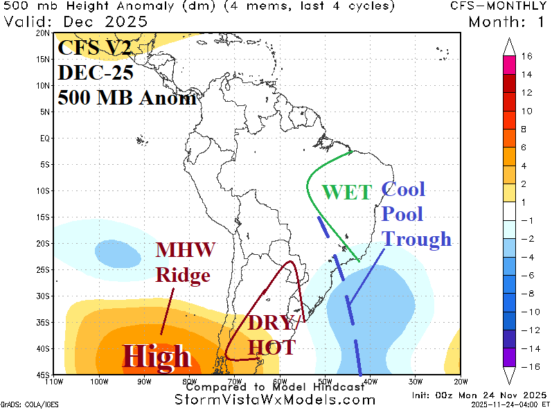
South America Weather Pattern Change In December

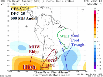
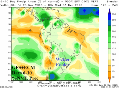
NOV-25 was mostly hotter/drier than normal across Central/Northeast Brazil while Argentina was temperate with patchy rain zones. In DEC-25, a pattern change is forecast. The catalyst to the pattern change is the influence on the upper air pattern of a marine heat wave (MHW) west of Chile and an evolving cool (SSTA) pool off the Central East Coast of South America
11/24/2025, 9:11 am EST
A map of the united states with red lines AI-generated content may be incorrect.

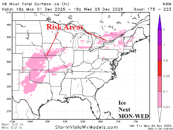
An Update on Snow and Ice Potential Associated with Colder U.S. Pattern Ahead

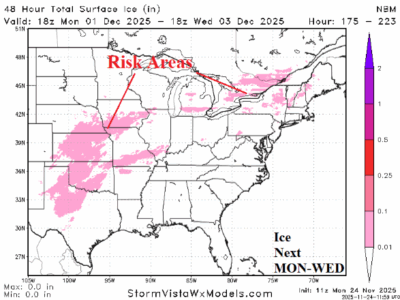
Using the National Blend of Models (NBM), the 48-hour snowfall valid today and tomorrow indicates potential for 5-10 inches across the northern Great Plains and Upper Midwest. The attendant storm moves towards James Bay midweek and strengthens causing heavy snow across Upper Michigan and Ontario with significant snow downwind the Great Lakes.
11/24/2025, 3:39 am EST
A graph of temperature and temperature AI-generated content may be incorrect.

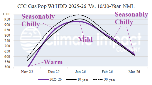
U.S. Winter 2025-26 HDD Forecast Update

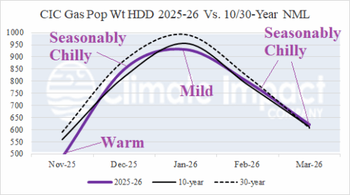
Latest review of what to expect for U.S. gas population weight HDD forecasts for the 2025-26 cold season. November was warm with colder weather arriving for December followed by a January thaw and seasonably cold late winter. The climate forecast is SSTA-based and doubts major polar vortex events except for early and late meteorological winter but with limited exposure to the high population East.
11/23/2025, 1:05 pm EST
A map of the weather AI-generated content may be incorrect.

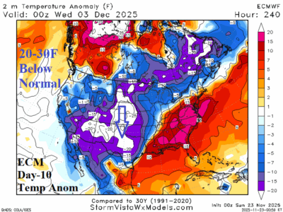
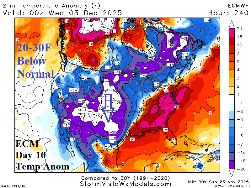
Potential Very Cold, Snow, and Ice for Central/East-central U.S. Early December

Early December is trending cold to very cold, snowy (and icy) for the Great Plains and possibly Texas eastward to the Ohio Valley to northern New England. Today's midday 12Z GFS is very aggressive with this potential scenario. The widespread and southern expanse of potential snow enhances the cold and limits moderation reaching Texas. The cold is less likely to impact the East.