News
11/24/2025, 9:11 am EST
A map of the united states with red lines AI-generated content may be incorrect.

An Update on Snow and Ice Potential Associated with Colder U.S. Pattern Ahead

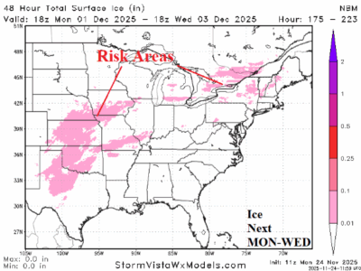
Using the National Blend of Models (NBM), the 48-hour snowfall valid today and tomorrow indicates potential for 5-10 inches across the northern Great Plains and Upper Midwest. The attendant storm moves towards James Bay midweek and strengthens causing heavy snow across Upper Michigan and Ontario with significant snow downwind the Great Lakes.
11/24/2025, 3:39 am EST
A graph of temperature and temperature AI-generated content may be incorrect.

U.S. Winter 2025-26 HDD Forecast Update

Latest review of what to expect for U.S. gas population weight HDD forecasts for the 2025-26 cold season. November was warm with colder weather arriving for December followed by a January thaw and seasonably cold late winter. The climate forecast is SSTA-based and doubts major polar vortex events except for early and late meteorological winter but with limited exposure to the high population East.
11/23/2025, 1:05 pm EST
A map of the weather AI-generated content may be incorrect.

Potential Very Cold, Snow, and Ice for Central/East-central U.S. Early December

Early December is trending cold to very cold, snowy (and icy) for the Great Plains and possibly Texas eastward to the Ohio Valley to northern New England. Today's midday 12Z GFS is very aggressive with this potential scenario. The widespread and southern expanse of potential snow enhances the cold and limits moderation reaching Texas. The cold is less likely to impact the East.