11/21/2025, 12:54 pm EST
A map of the north america AI-generated content may be incorrect.

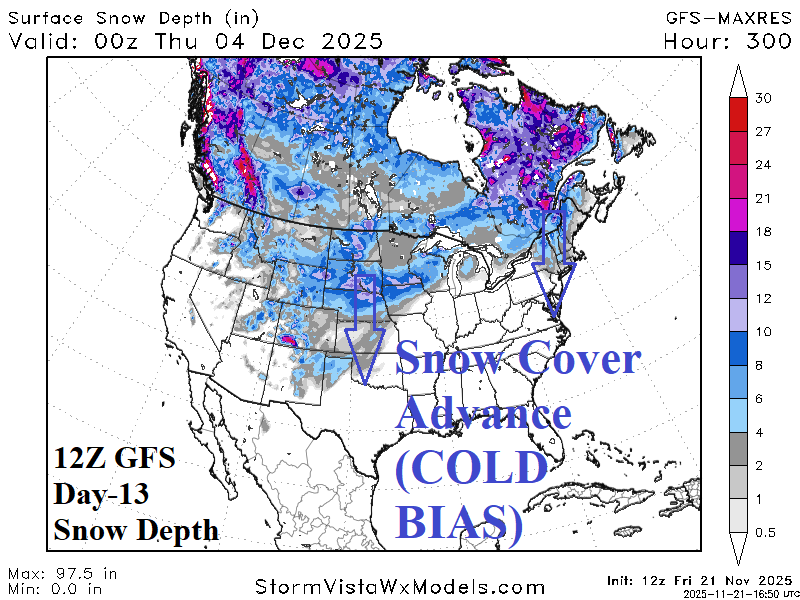
Expected Evolving Snow Cover Is The Cold Weather Key for December

The chart to remember, heading into the weekend, is the 12Z GFS snow depth forecast for day-13 (Dec 3rd). Unlike the over-forecasting of snow tendency of the GFS (and ECM), snow depth forecasts are conservative and (more) reliable. On Dec. 3rd the 12Z GFS projects substantial snow cover pushing southward through the Great Plains and across New England.
11/20/2025, 12:44 pm EST
A map of the united states AI-generated content may be incorrect.

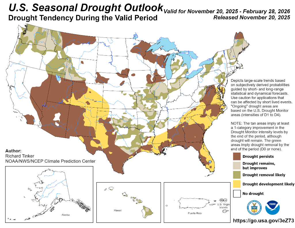
Latest NOAA/CPC Seasonal Drought and Long-lead Climate Forecasts

The latest NOAA/CPC Seasonal Drought Outlook indicates expanding drought from the Southwest U.S. across the 4-Corners region and Western Texas plus into the Mid-Atlantic region from the Southeast U.S. The Florida Peninsula is added to the developing drought forecast. Drought erosion is indicated across the northeast quadrant of Texas northeastward to the Midwest States. New England drought also eases. The Northwest U.S. drought is forecast to weaken (and end in some locations). Except for south coastal areas, drought development in California is not expected.
11/20/2025, 8:54 am EST
A map of the south america AI-generated content may be incorrect.

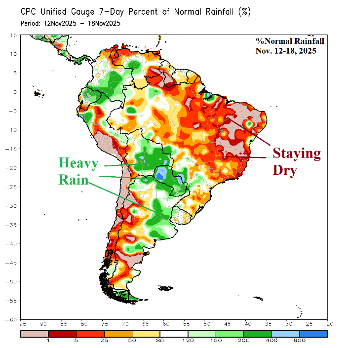
Central South America Rains Forecast to Shift Into Brazil

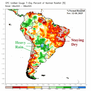
Operational forecasts continue to indicate a wet weather shift to Brazil. The mega-cluster ensemble indicates wet weather risk is highest in Northeast Brazil into the weekend while Argentina turns drier. The drier trend for Argentina is also evident during the medium range while wet focus shifts to East Brazil.
11/20/2025, 5:53 am EST
A map of the weather AI-generated content may be incorrect.

Unusual for La Nina Climate…Heavy Rains Texas

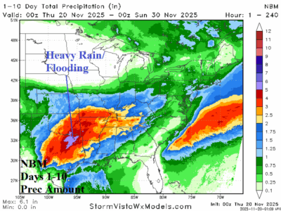
Excessive rainfall with flood risk is forecast for today southwest of San Antonio and in Arkansas. Excessive rainfall with flood risk returns to Texas and the southeast Great Plains SUN/MON. The NBM 10-day rainfall forecast indicates 5-7 in. of rain just north of Dallas.
11/19/2025, 4:48 am EST
A graph of the global warming AI-generated content may be incorrect.

Climbing Heating Degree Days in U.S. as December Arrives

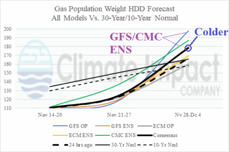
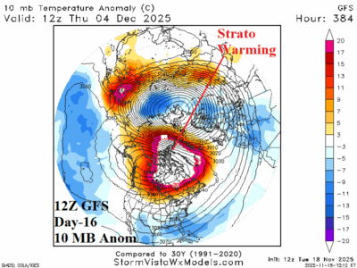
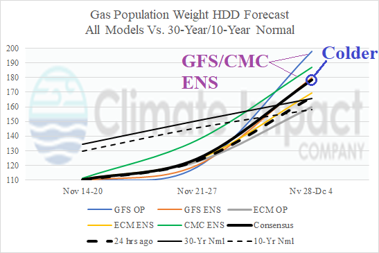
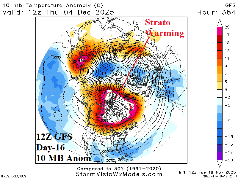
Stratospheric warming is developing on the North America side of the North Pole now, strengthening in the 6-10-day period, and peaking across northwest continent during the 11-15-day period. The attendant colder temperature trend at ground level causes a surge in U.S. gas population weight HDD for the week ending December 4th.
11/19/2025, 4:41 am EST
A map of different colors AI-generated content may be incorrect.

Stormy and Cold Europe!

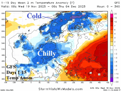
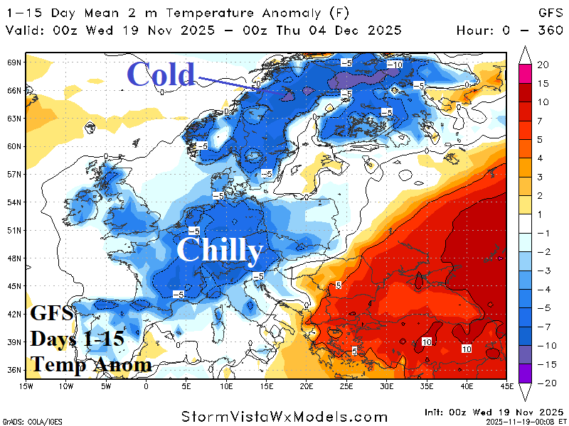
According to GFS, a semi-permanent upper-level longwave low-pressure trough anchors over Europe during the remainder of November causing a chilly pattern to develop also featuring heavy precipitation. At night, widespread 20’s (F) cover Europe into early December with teens (F) across Scandinavia and Northwest Russia. <32F reaches the British Isles.
11/17/2025, 11:36 am EST
A graph of different colored lines AI-generated content may be incorrect.

La Nina Gaining Strength

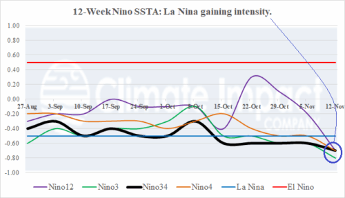
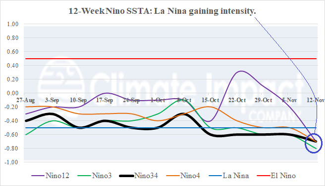
La Nina suddenly displays life with notable strengthening during the past 1-2 weeks. All Nino SSTA regions are within the La Nina threshold. The catalyst to the cooler change is a consistent and strengthening positive phase of the southern oscillation index (+SOI) causing a steady increase in up-welling trade winds and shifting the global climate convincingly into a cold ENSO regime.
11/17/2025, 4:34 am EST
A graph of different colored lines AI-generated content may be incorrect.

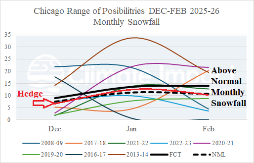
Chicago and Boston Winter 2025-26 Snowfall Forecast

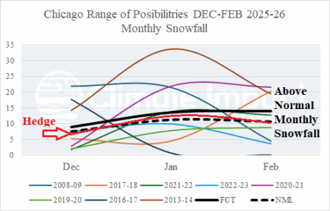
The projected SSTA regime and SSW risk are found in 7 different analog years in the modern climate era (since the mid-to-late 1990’s). Each year has an assigned statistical weight based on the strength of the analog. The consensus of the analog years yields an above normal snowfall each month of meteorological winter 2025-26 in Chicago and Boston (except for February).
11/17/2025, 4:30 am EST
A map of weather forecast AI-generated content may be incorrect.

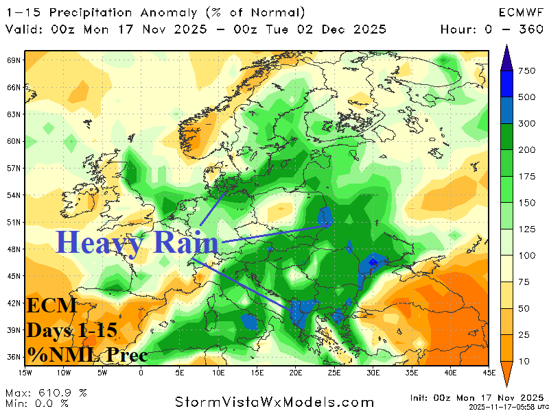
Europe Outlook To Close November Stormy/Wet

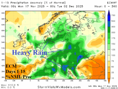
The upper air pattern projected across Europe during the next 1-2 weeks features a deep upper-level low-pressure trough causing chilly weather for the next 10 days (at least) and excessive rainfall capable of producing flooding in parts of central, south, and southeast portions of Europe. Heavy snows are likely in the South-central Europe mountain areas, and the wet regime extends eastward to include Ukraine.
11/16/2025, 12:19 pm EST
A map of the united states with different weather conditions AI-generated content may be incorrect.

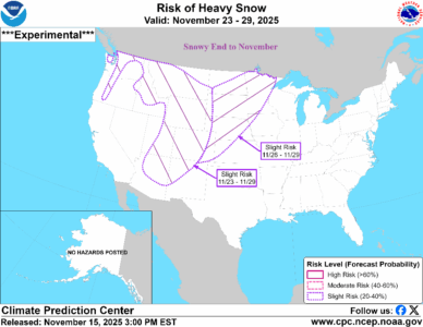
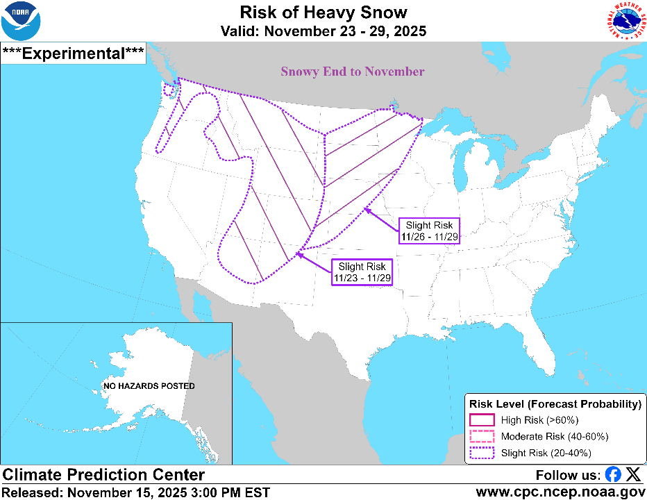
Snowy Last Week of November Northwest/North-central U.S.

Typical of a La Nina climate, the Northwest U.S./Southwest Canada to North-central U.S. are usually the first winter targets for cold and snow. The NOAA/CPC risk of heavy snow ALERT for the last week of November indicates heavy snow risk for the Continental Divide and North-central U.S. likely to sustain following cold.
11/16/2025, 12:17 pm EST
A map of the south america AI-generated content may be incorrect.

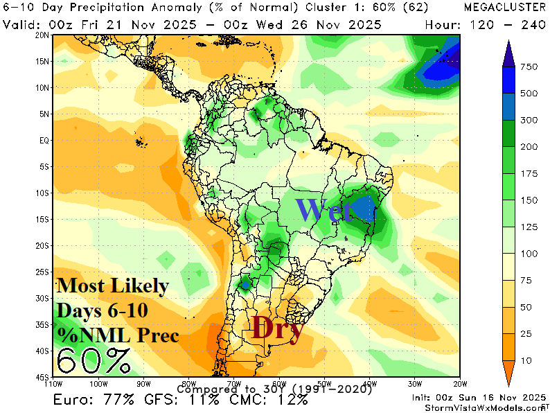
Anticipated Wetter Brazil Pattern Initiates in the 6-10-Day Period

A wet weather shift from Argentina and more recently central continent into Central/East Brazil initiates in the 6-10-day period according to the "most likely" mega-cluster ensemble. The wetter shift should remain in-place well through early meteorological summer 2025-26 while Argentina shifts drier.