Pattern Change Ahead Great Plains, Brazil, and Europe
11/13/2025, 8:39 am EST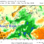
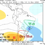
Europe Outlook To Close November Stormy/Wet
11/17/2025, 4:30 am ESTClimate Impact Company U.S. Sunday Report
Issued: Sunday, November 16, 2025
Highlight: Windy Northeast/Mid-Atlantic today, excessive rainfall SUN/MON California Coast, and heavy rain Mid-south by THU.
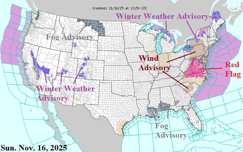
Fig. 1: The NOAA/NWS weather watch, warning, and advisory areas.
Discussion: High impact weather in the East today as trailing a cold front moving offshore this morning, gusty west-northwest wind follows. Wind Advisories are issued for New York to Maryland where scattered power outages are likely (Fig. 1). A Red Flag Warning is issued for Virginia. Lake-effect snow develops, heaviest in Northwest Pennsylvania while Winter Storm Warning’s are posted for Upstate New York and Northern Vermont. Widespread morning fogs are spread across the Central Gulf States and northwest Great Plains. Winter weather has spread across the Interior West with heaviest snows for the Sierra Nevada.
The short-term NOAA/WPC quantitative precipitation forecast (QPF) indicates storminess to start the week is focused on the West with excessive rain/flood risk in coastal areas south of San Franciso today and the Los Angeles Basin tomorrow (Fig. 2). The West Coast storm rolls eastward causing rain to develop midweek becoming heavy, including thunderstorms, and flood risk from Texas to Missouri (Fig. 3).
Typical of a La Nina climate, the Northwest U.S./Southwest Canada are usually the first winter targets for cold and snow. The NOAA/CPC risk of heavy snow ALERT for the last week of November indicates heavy snow risk for the Continental Divide and North-central U.S. (Fig. 4).
The snowy end to November for the northwest/north-central portion of the U.S. guarantees a trend toward a colder temperature pattern. Consequently, the consensus of operational models yields a warm to near normal national heating demand trend during the next 2-3 weeks (Fig. 5). The week 4-6 forecast is warm CFS V2, cold North (ECM), or very cold North (AI). Snow cover increase will guide the December cold therefore, maintained is the Climate Impact Company constructed analog temperature anomaly forecast for December: Cold over snow, warm south of snow (Fig. 6).
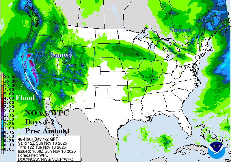
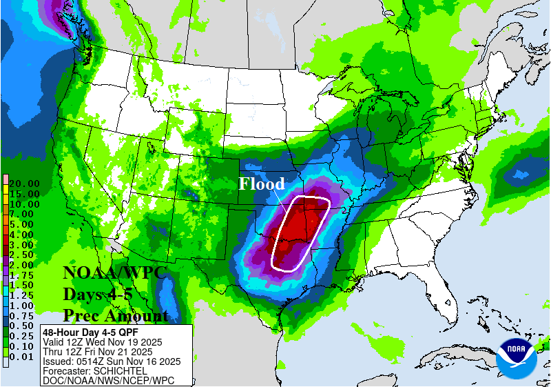
Fig. 2-3: NOAA/WPC days 1-2 and days 4-5 quantitative precipitation forecast.
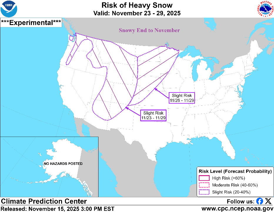
Fig. 4: The NOAA/CPC risk of heavy snow areas for Nov. 23-29.
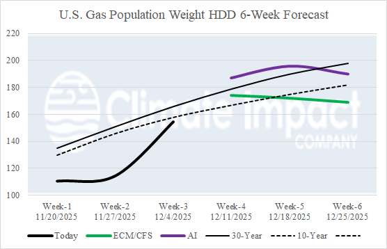
Fig. 5: The U.S. gas population weight HDD forecast utilizing all models through Dec. 4 and estimated HDD based on CFS V2/ECM consensus and AI weeks 4-6.
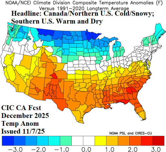
Fig. 6: The best guide to December 2025 temperature pattern, the CIC-CA outlook.