08/29/2025, 4:57 am EDT
A map of the world AI-generated content may be incorrect.

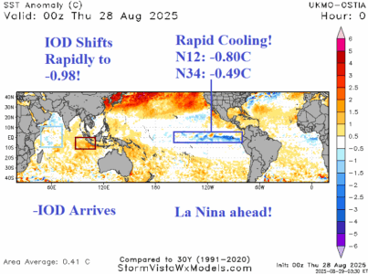
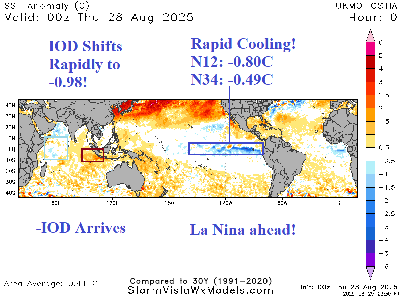
Strong Negative Indian Ocean Dipole Arrives; La Nina Approaching!

During the past week, the Nino SSTA regions have cooled dramatically. The Nino34 SSTA is -0.49C today, very close to the -0.50C La Nina threshold. Off the northwest coast of South America, the Nino12C chilled rapidly to -0.80C. In the tropical Indian Ocean, the western areas have cooled while the southeast tropics have warmed dramatically signaling a moderate-to-strong negative Indian Ocean dipole (-IOD).
08/28/2025, 9:48 am EDT
A map of the world AI-generated content may be incorrect.

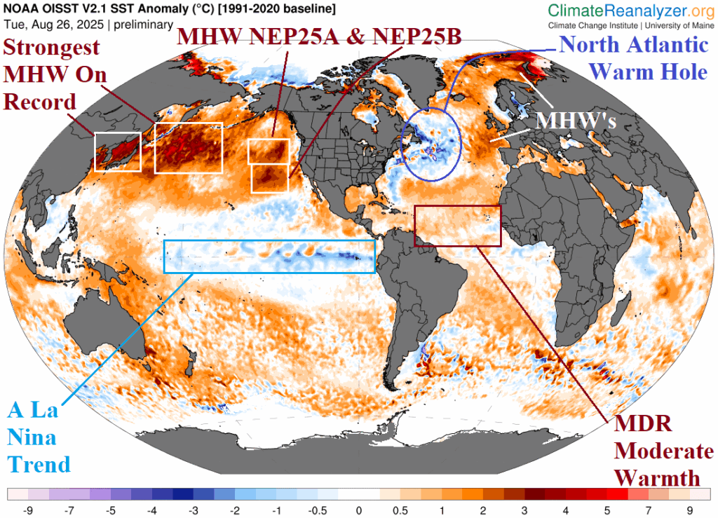
The Northern Hemisphere Upper Air Pattern Changes in September

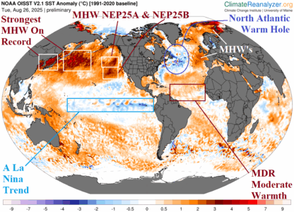
The strongest marine heat waves (MHW) on record in the West Pacific and in-between Japan and the Asia Coast extending to MHW’s NEP25A and NEP25B in the Northeast Pacific are well-correlated to the summer 2025 upper air pattern featuring a strong upper-level high-pressure ridge. Similarly, the MHW’s in the east/northeast portion of the North Atlantic are well-correlated to a semi-permanent upper-level high-pressure ridge dominating the west/south portion of Europe during summer 2025.
08/27/2025, 5:33 am EDT
A map of the united states AI-generated content may be incorrect.

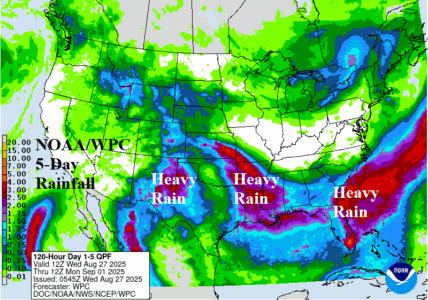
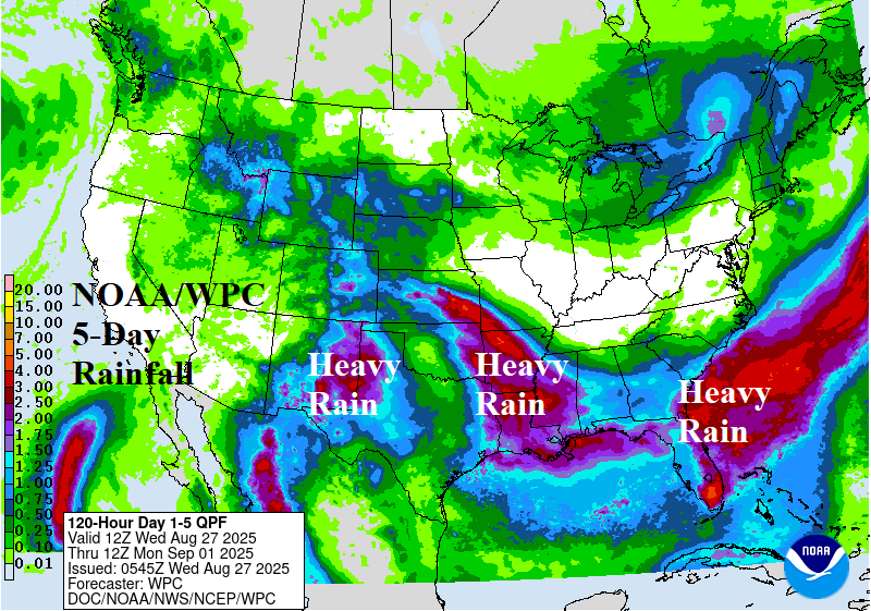
Heavy Rains Shift Across Southern U.S.

Significant wet weather shifts across the southern U.S. over the next 5 days. Excessive rain causing a flood risk emerges in Kansas today and Arkansas tomorrow (where severe storms are likely). Excessive rain causes flooding across Western Texas late week. The 5-day rainfall totals through the weekend are in the 3-5-inch range centered on Arkansas/Louisiana, the Southeast Coast including Florida, and the New Mexico/Texas state line.
08/27/2025, 5:29 am EDT
A map of the earth AI-generated content may be incorrect.

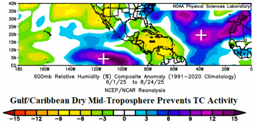
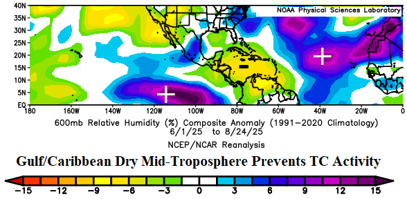
Why Is Gulf of Mexico and Caribbean Sea Lacking TC’s So Far?

The Gulf of Mexico and Caribbean Sea have been exceptionally quiet regarding tropical cyclone activity through late August despite moderately warmer than normal ocean surface temperatures. The primary reason for the lack of tropical cyclone activity is the dry mid-troposphere. The dryness in this region is compensation for a wet mid-troposphere across the eastern tropical Pacific and eastern half of the North Atlantic tropics.
08/26/2025, 1:30 pm EDT
A map of the world AI-generated content may be incorrect.

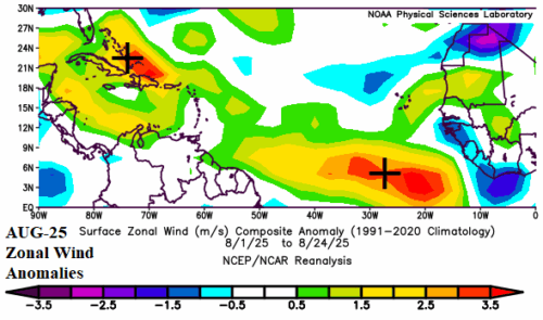
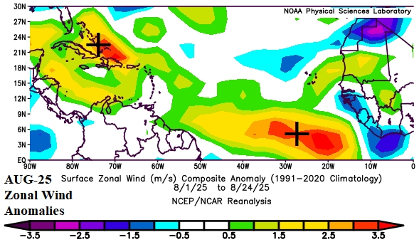
Strong Tradewinds Prevent Deep Tropics to Gulf Significant Storms So Far

Tropical cyclone activity during 2025 so far has featured tropical cyclone tracks mostly near and off the U.S. East Coast. One possible explanation for lack of activity in the Gulf of Mexico, Caribbean Sea, and deep tropics is the persistent (much) stronger than normal trade winds preventing systems from developing.
08/25/2025, 10:22 am EDT
A map of the world with a number of different colors AI-generated content may be incorrect.

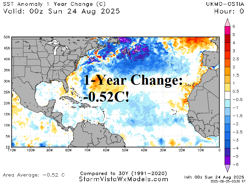
North Atlantic Basin Regions of SSTA Analysis

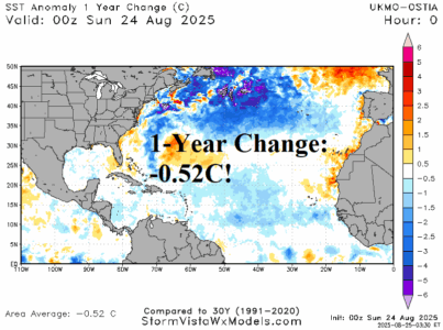
The lack of tropical cyclone activity across the Gulf of Mexico and Caribbean Sea is allowing each basin to shift warmer. The Gulf of Mexico is nearly 1C warmer than normal and warmer by 1/3C during the past 30 days. The Caribbean Sea has warmed by 2/10C during the past 30 days to 0.65C. However, the North Atlantic basin is marginally warm at +0.34C and much cooler than 1 year ago by 0.52C.
08/24/2025, 11:45 am EDT
A map of europe with red and yellow spots AI-generated content may be incorrect.

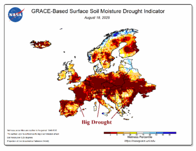
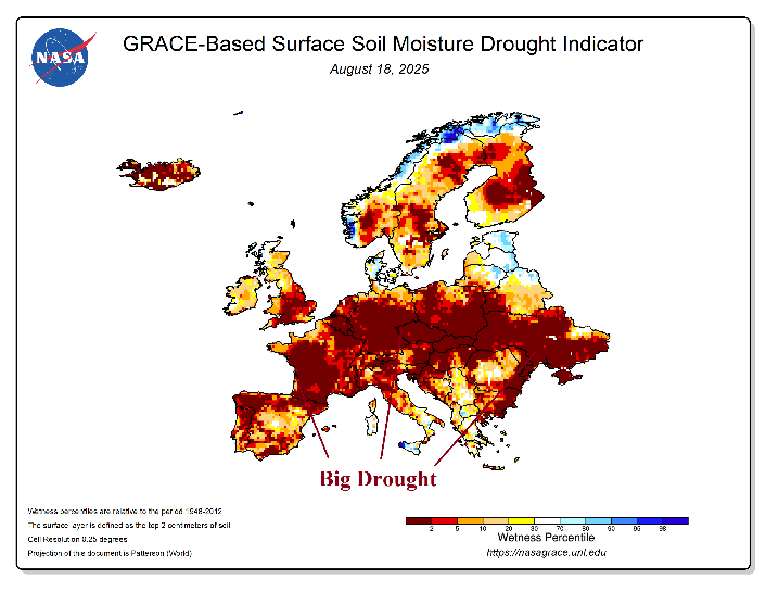
Europe Drought to Receive Beneficial Rainfall

Europe continues to encounter widespread harsh drought. The drought is related to the NAWH-trough and downstream ridge pattern, common during the past decade especially during the warm season. However, pattern change is on the way.
08/24/2025, 9:16 am EDT
A graph of a severe weather AI-generated content may be incorrect.

North Atlantic Tropics: SEP/OCT/NOV Should Become Active!

Other than Erin, the 2025 season has been quiet so far. However, during the 2016-24 active period, after September 1 is typically quite active featuring 7 hurricanes and 3 intense hurricanes. As September 2025 approaches, the North Atlantic basin is warmer than normal but arguably the least warm since 2015. Previously, 2018 produced least warm North Atlantic basin SSTA during September when peak tropical cyclone activity occurs. However, in 2018 a weak La Nina was forming and in 2025, signs of a weak La Nina are ahead. Therefore, despite the less warm North Atlantic, the La Nina tendency should produce a favorable atmospheric environment for tropical cyclone development during SEP/OCT/NOV 2025.
08/22/2025, 5:20 am EDT
A map of the weather AI-generated content may be incorrect.

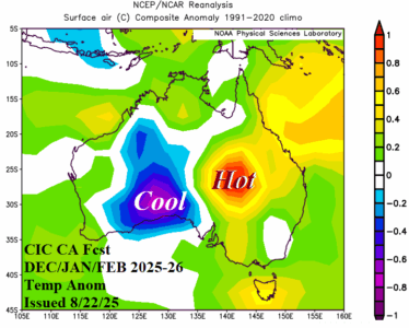
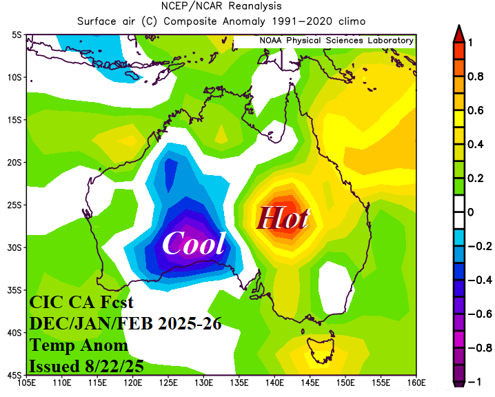
Wet/Cool Spring Followed by Evolving Summer Heat/Dryness East Australia

The Climate Impact Company constructed analog climate outlooks for meteorological spring 2025 and winter 2025-26 is issued. The spring season is mostly cooler than normal across much of the continent with a wet bias in the East. The summer outlook reverses drier and hotter in the East.
08/21/2025, 3:56 pm EDT

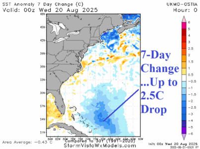
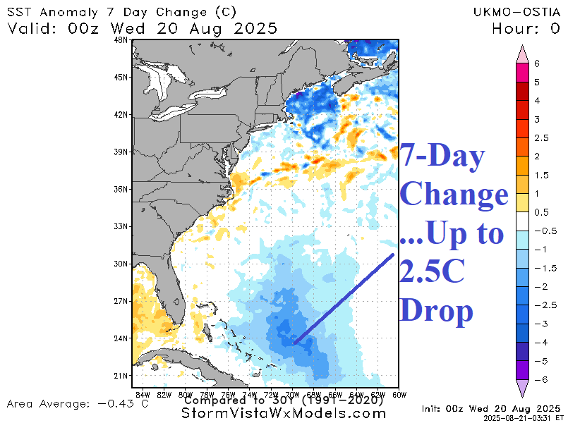
Erin Significantly Cools Waters East of Bahamas

Erin has significantly cooled the ocean surface east of the Bahamas. SST in the core of the cooler zone are 80-81F, below the threshold to sustain a tropical cyclone. The 7-day SST change in near 2.5C due east of the Bahamas. To the north of Puerto Rico, north of 25N, the SST are somewhat warmer than normal which explains the potential hurricane intensity of tropical cyclone models for 90L.
08/20/2025, 6:43 am EDT
A graph showing a line AI-generated content may be incorrect.

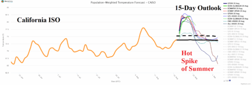
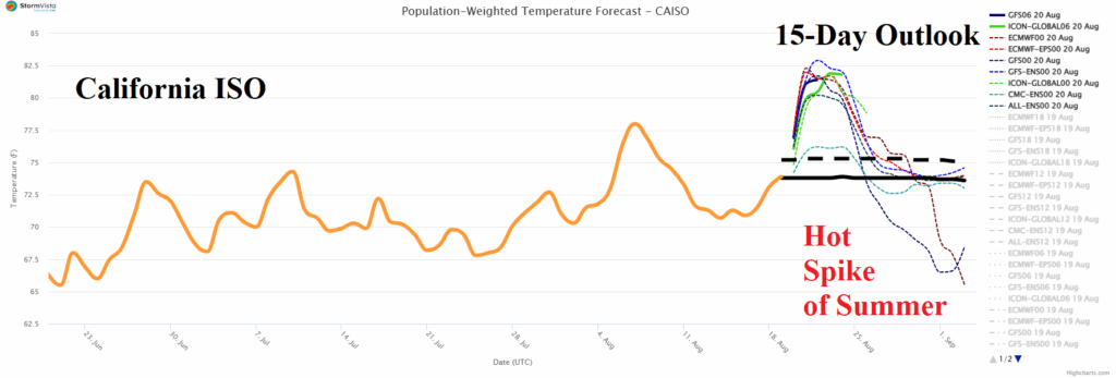
Hottest Event of Summer 2025 in California

Intense heat will spread across much of California during the next few days leading to the hottest summer 2025 event of the season. Sacramento and Burbank reach 102F THU/FRI; San Jose to 95F tomorrow; Bakersfield 108F on Friday. Farther east, Las Vegas reaches 110F and Phoenix 112F on Thursday.
08/20/2025, 5:40 am EDT
A map of africa with different colors of soil moisture AI-generated content may be incorrect.

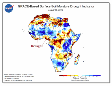
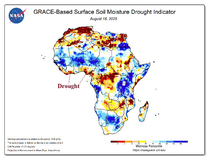
West Africa Cocoa Update…Cocoa-Growing Areas Drought Continues

The soil moisture conditions across cocoa-growing zones of West Africa are in drought for the southern portion. A wet climate and attendant soil conditions are not far to the north but likely to stay north of coastal West Africa.