01/30/2026, 5:05 am EST

High Wind Event This Weekend Northeast/Mid-Atlantic Coast

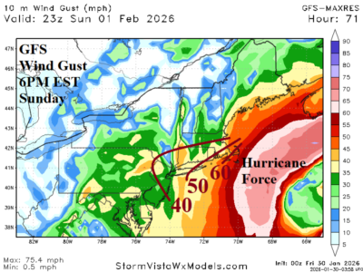
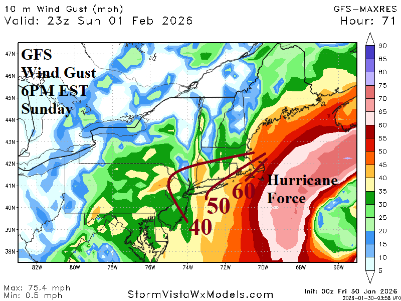
A larger concern for the Northeast Corridor Coast this weekend is high wind propelling high sea conditions as the offshore system produces hurricane force wind with 50-60 MPH gusts reaching the coast and 40+ mph away from the coast.
01/30/2026, 5:03 am EST

Southern U.S. Drought Ends if El Nino Forms in 2026

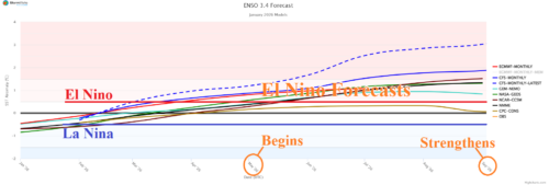
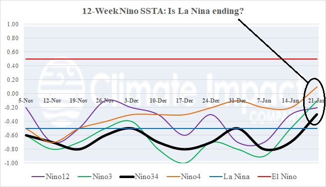
The U.S. Drought Monitor reveals widespread dry-to-drought conditions across the U.S. biased toward the South and Southeast U.S. due to the La Nina climate. About 68% of the U.S. are observing dry-to-drought conditions although D2-D4 severe drought is observed by only 3% of the U.S. Nino34 SSTA forecasts are aggressively indicating El Nino ahead for 2026. If so, the Southern U.S. shifts wetter and long-term drought eases or ends.
01/29/2026, 5:08 am EST

High Impact Weather Next 10 Days Argentina and Brazil

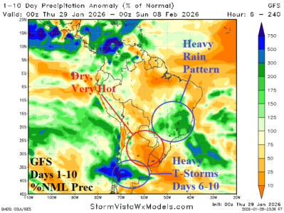
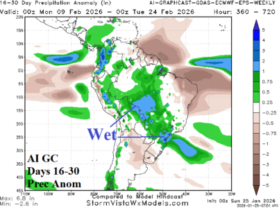
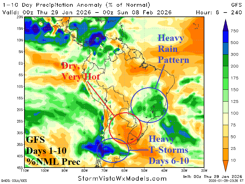
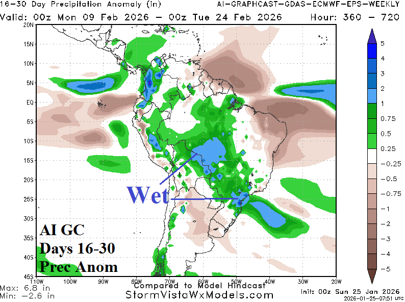
In South America, several weather hazards are indicated in the GFS 10-day precipitation outlook. Developing heavy rains last through the next 10 days east of Paraguay to the Southeast Brazil Coast. Meanwhile, Northern Argentina is dry and extremely hot through 10 days. The exception is an area of heavy thunderstorms in Central Argentina during the 6-10-day period.
01/29/2026, 4:13 am EST

High Impact Cold Weather Continues East; Colder Shift for February 6-12

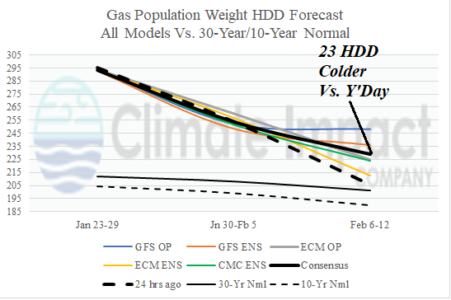
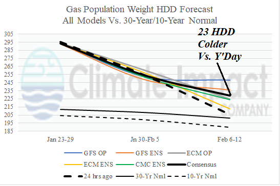
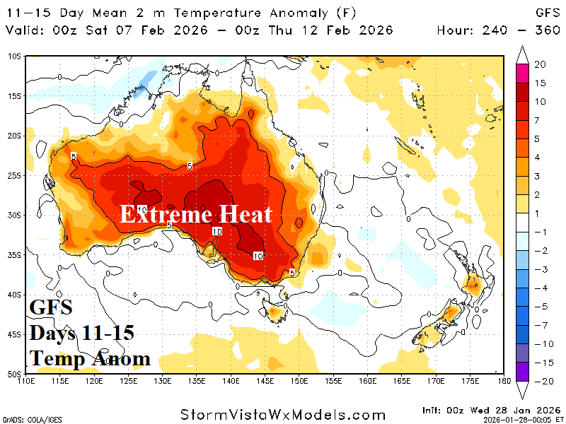
The ongoing negative arctic oscillation (-AO) is in-the-face of any significant U.S. warm-up. Overnight, forecasts are trending colder in the 11-15-day period, particularly GFS, as -AO inspires cross-polar flow of arctic chill into the U.S. Consequently, the February 6-12 HDD forecast increases substantially, 23 HDD from 24 hours ago.
01/28/2026, 9:07 am EST

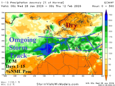
-AO Sustains Northern Europe Cold and Energetic Southern Europe Storm Track

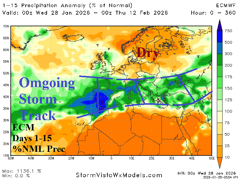
Well-documented is the cold influence on North America and Eurasia climate by an ongoing intense negative arctic oscillation (-AO). Additionally, -AO has inspired a vigorous Southern Europe storm track most recently associated with Winter Storm “Kristin” and effects on Portugal and Spain. -AO continues well into February maintaining the energetic Southern Europe storm track.
01/28/2026, 5:04 am EST

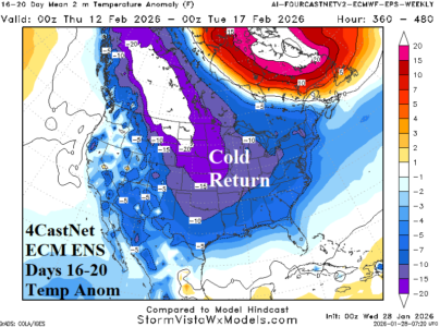
The “Caveat” Forecast…A Case for Regenerating Cold

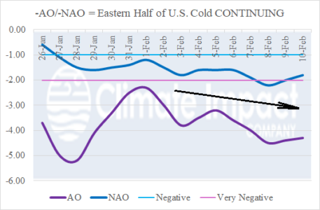
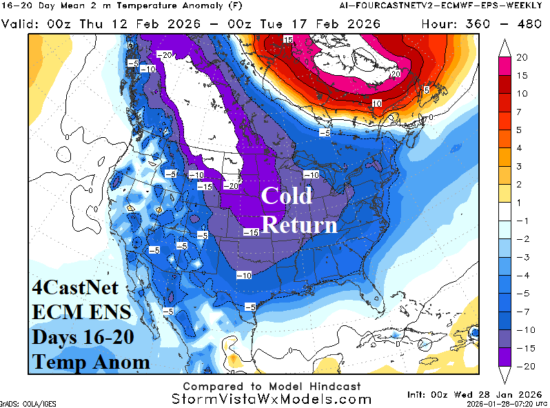
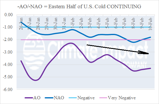
The 30-day AO index (Jan. 21-Feb. 19) is projected -3.6 based on recent observations and projections for the 30-day period. The AO index of -3.6 is exceeded only twice as a monthly average in the 1950-2026 climatology: -4.3 (FEB-2010) and -3.8 (JAN-1977). Ongoing -AO (and strengthening -NAO) suggest the current extreme cold may break temporarily and then return.
01/26/2026, 3:59 pm EST

Active East Pacific MJO + -AO/-NAO = Atlantic Coast Weekend Snowstorm

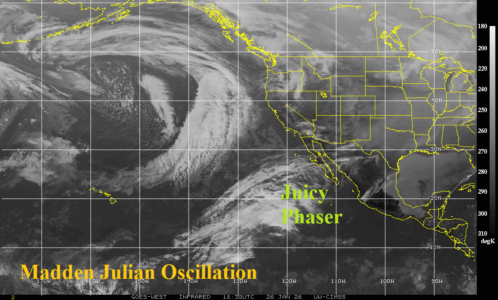
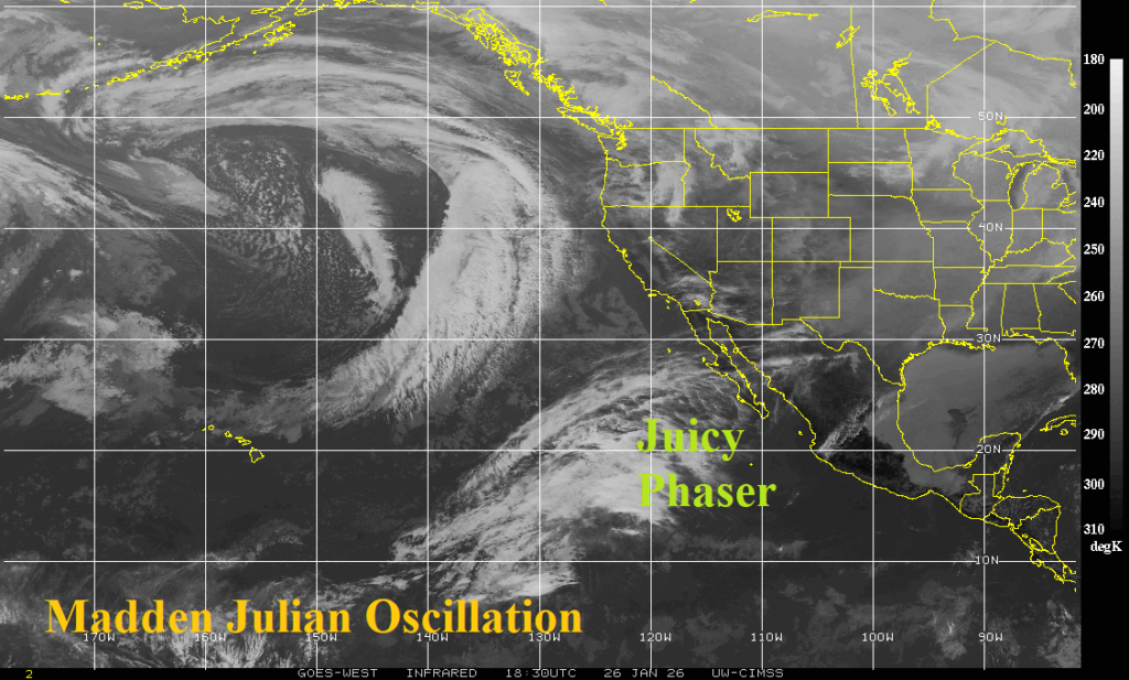
The convection phase of the Madden Julian oscillation (MJO) remains active in the East Pacific as identified by tropical convection near the equator and a streak of energy associated with the subtropical jet stream pointed at Baja California. Given presence of negative arctic oscillation (-AO) and negative North Atlantic oscillation (-NAO) coupled with the active MJO, the emerging coastal storm indicated by the 12Z GFS and 12Z ECM have excellent support.
01/26/2026, 3:54 pm EST

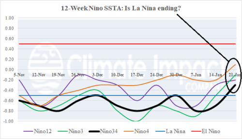
Oceanic La Nina Ends

The MJO was the catalyst to the aerial coverage and intensity of the January 24-25 weekend storm. The event also caused the East Pacific equatorial region to warm. Effective this week, oceanic La Nina has ended as all Nino SSTA regions have shifted to neutral phase.
01/26/2026, 4:29 am EST

Historic -AO, Strengthening -NAO, Cold Pattern Expands in February for U.S.

The projected AO for February is about -2.6 which is historically negative. Similarity was observed in 1985, 1998, 2010, and 2011 when the following February maintained the cold U.S. trough. The modern day -AO analog (2010 and 2021) was slightly less effectively cold. The analogs suggest the East U.S. cold expands westward with time during February.
01/25/2026, 6:17 am EST

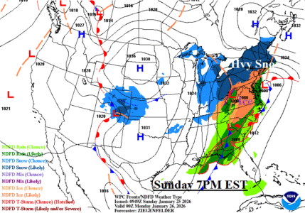
U.S. Winter Storm Update: Over to Mostly Ice Interior Mid-Atlantic Today; 1-2 Feet of Snow New York/New England

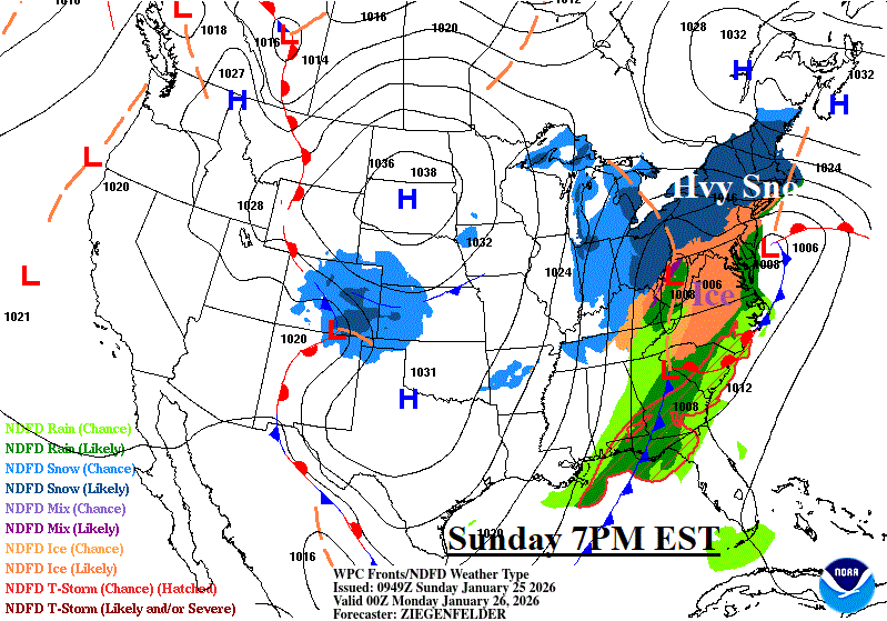
The latest snowfall forecast indicates 18-24 inches of snow from Albany to Boston today and Monday. 10-18 inches of snow extends from Ohio across Pennsylvania. Amounts are cut back Maryland and southward due to sleet and freezing rain. The core of major ice accretion stretches from Eastern Louisiana to Kentucky, the Southern Appalachians, and Raleigh to Richmond.