01/23/2026, 4:43 pm EST

U.S. Storm Update and Long-duration (East) Cold

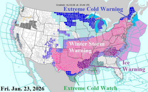
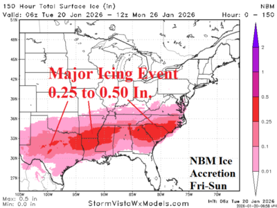
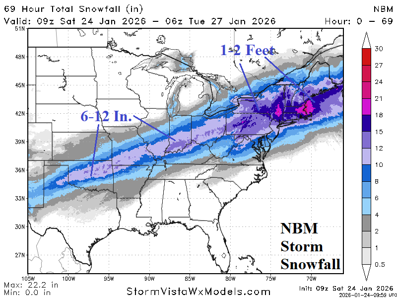
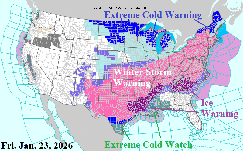
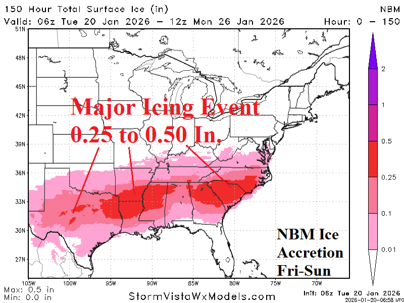
By late Friday afternoon, Winter Storm Warnings expanded south to the Houston area and eastward to the Atlantic Seaboard. Initial focus zones for severe icing are East Texas, the northern 2/3 of Louisiana, southern Arkansas, and northern Mississippi plus northern Georgia and the western half of South Carolina.
01/23/2026, 3:12 pm EST

Extended-range U.S. Forecasts Rebuilds The Cold

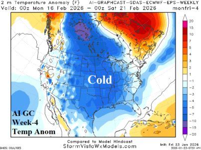
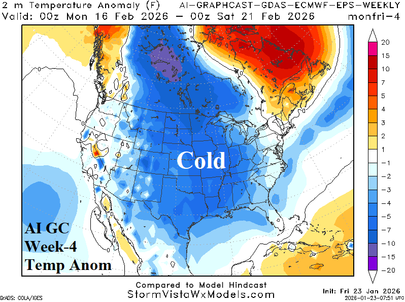
Leading into the 15+ day period negative phase arctic oscillation continues and negative North Atlantic oscillation strengthens. Coupled with snow cover, the East U.S. cold continues and eventually re-widens. Cross polar arctic air flow fuels another cold blast week-4 ahead for the Central U.S. Additionally, cold week-4 forecasts by AI were correct (from early January) for the current pattern. Finally, strong -AO in January has historical precedent to continue in February.
01/22/2026, 12:36 pm EST

Out Of Control U.S. Cold Including A Double Dip Across ERCOT

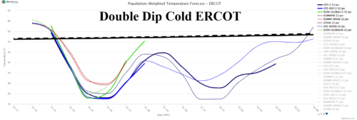
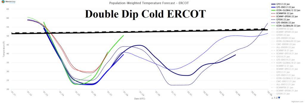
The latest 15-day ERCOT daily temperature average outlook indicates a double dip of cold weather ahead centered on Houston. The evolving double dip cold rival other cold outbreaks for Texas this decade. The 12Z GFS enhances the cold air mass over snow cover in the 6-10-day period where record cold is likely.
01/22/2026, 11:58 am EST

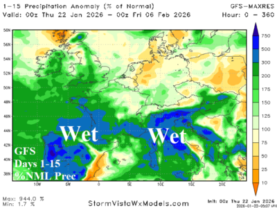
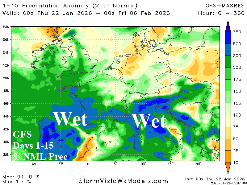
West/South Europe Heavy Rains Ahead

West and South Eur with an attendant warming influence especially across Southeast Europe and Black Sea region.
01/22/2026, 9:56 am EST

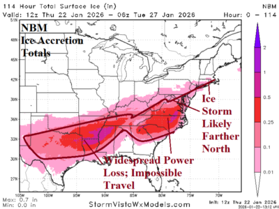
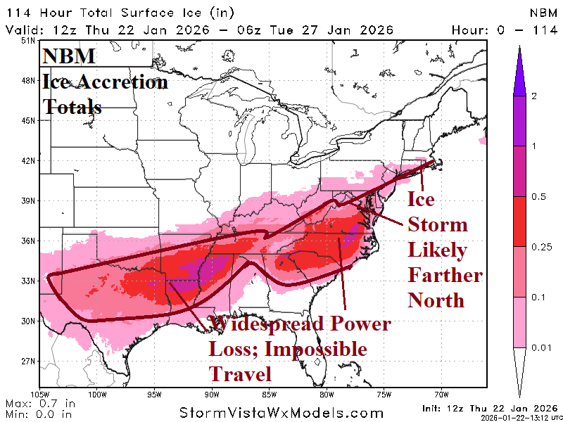
Significant Ice Accretion Forecast Edging Northward for Weekend Storm Especially Mid-Atlantic

The new concern is a larger exposure of significant ice accretion, especially northward through the Mid-Atlantic region to the south and southeast coast of New England. Already, widespread power loss and impossible travel due to a major ice accretion is forecast for the Mid-south U.S. plus the Carolinas. However, the ice accretion forecast trend leaves Virgina in a similar risk and Washington/Baltimore/Philadelphia could be added.
01/21/2026, 4:43 pm EST

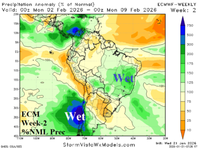
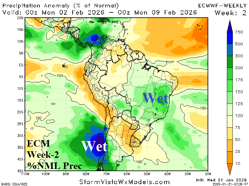
MJO Shift Favors Wetter Brazil Pattern Ahead

As the Madden Julian oscillation shifts eastward through the longitudes of the Americas, a wetter bias to the Brazil weather pattern unfolds. The recent dry regime shifts wetter for later January and early February while Northeast Argentina is drier and hotter.
01/21/2026, 1:00 pm EST

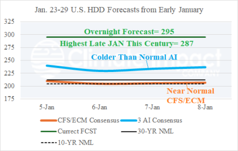
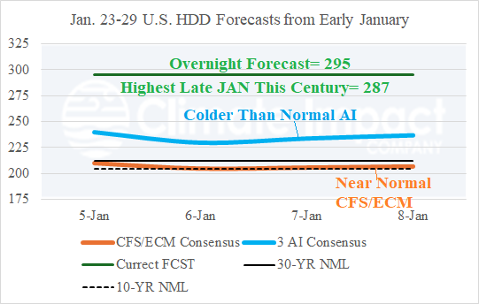
Week-4 AI HDD Forecasts from Early January Were Very Cold for Last Week of January

The U.S. HDD outlook in today’s week-4 outlook is colder than normal utilizing a consensus between AI 4CastNet V2 ECM ENS, AI 4CastNet V2 GFS ENS, and AI Graph Cast ECM ENS. The CFS V2/ECM consensus is warmer. Of interest is the record strength 295 HDD forecast for the last week of January from overnight compared to week-4 forecasts made earlier this month. AI was much colder than the CFS V2/ECM consensus.
01/21/2026, 6:09 am EST

Incoming Arctic Air Triggers Major Snow and Ice Storm South and East U.S.

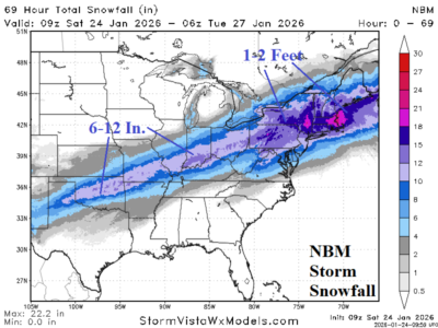
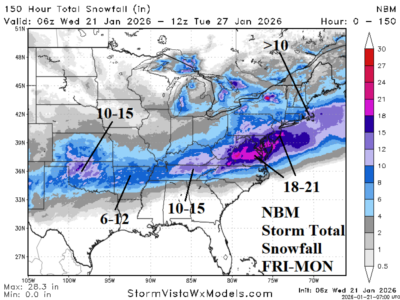
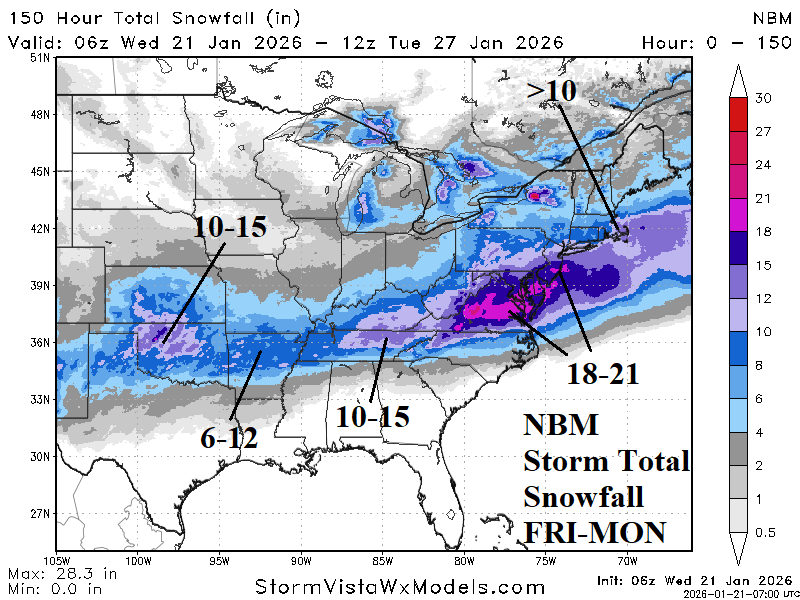
Along an arctic air boundary, a major ice storm develops Friday across the southern Great Plains extending to the Mid-south U.S. and quickly eastward Saturday into the Carolinas. The Interior Southeast is also affected. Ice accretion of 0.5 to 1.0 inches is possible in this stretch which will cause widespread power outages. Heavy snows extend from the southern Great Plains to the Tennessee Valley. Jackpot snows (18-21 inches) are forecast for Virginia. Southeast New England is added to the heavy snow risk.