01/12/2026, 9:09 am EST

Pacific Kelvin Wave Shifting Eastward and Strengthening

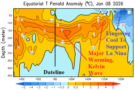
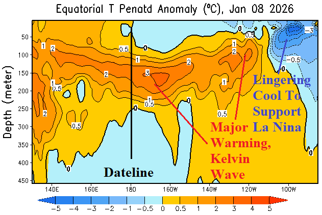
An impressive looking Kelvin Wave has moved east of the Dateline and has strengthened. Cool waters remain in the subsurface off the northwest coast of South America fueling La Nina cool signatures in the Nino SSTA regions.
01/11/2026, 11:54 am EST

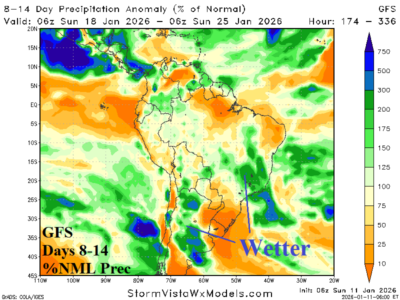
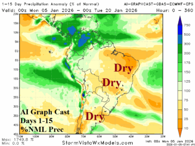
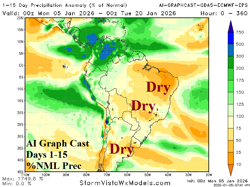
MJO East Shift Brings Wetter Bias to South America Last 1/3 of Month

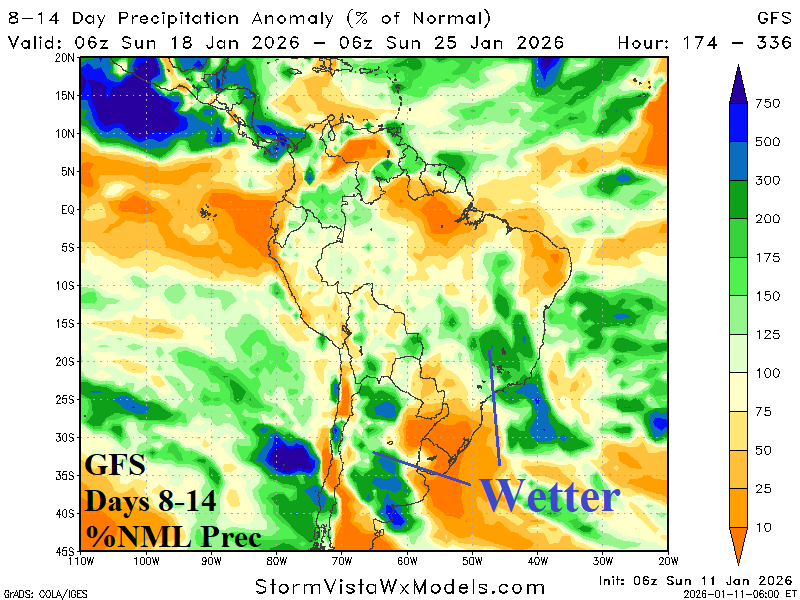
The convection phase of the Madden Julian oscillation (MJO) is moderately strong near the Dateline. Forecasts indicate an eastward shift toward the longitude of the Americas in the extended range. While the current (phase_6) of MJO favors a drier than normal climate for most of Argentina/Brazil, the shift into phase_7 favors broadly wetter than normal climate. Consequently, wetter 8-14/11-15-day (model) forecasts are favored. The wetter bias should last into the 16-20-day timeframe.
01/11/2026, 9:07 am EST

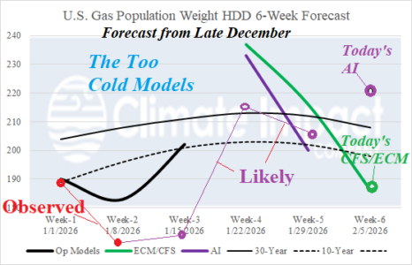
U.S. HDD Forecasts Have Been Too Cold

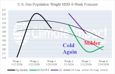
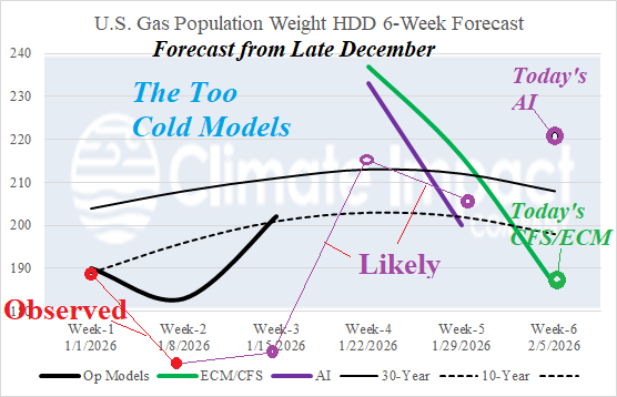
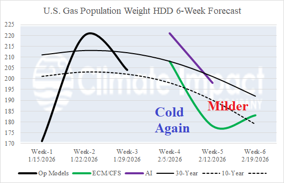
U.S. gas population weight HDD forecasts through 6 weeks from late December correctly identified the warmer early-to-middle January warmer trend although not as warm as observed. Today’s projection for the current week is MUCH warmer than forecast in late December and possibly the largest reason for natural gas price collapse late last week. Projections for week-4 are near the 30-year normal, somewhat less cold than both CFS/ECM and AI indicated from 2 weeks ago.
01/09/2026, 8:02 am EST

Fluctuating Heating Demand Ahead in the U.S.

The latest U.S. gas population weight HDD forecast identifies the mild week ahead shifting much colder Jan. 16-22 and moderating back to near normal late month. AI and CFS/ECM each indicate another cold week to start February followed by milder weather. Arctic air risk is not indicated (for the U.S.) during the period.
01/09/2026, 5:29 am EST

NW HYDRO & The Northeast Pacific “Warm Blob”; U.S. Drought Monitor, Latest EDDI, and CAS Soil Moisture Outlook

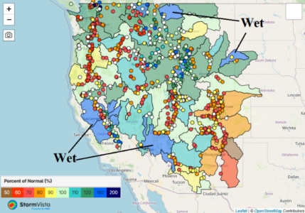
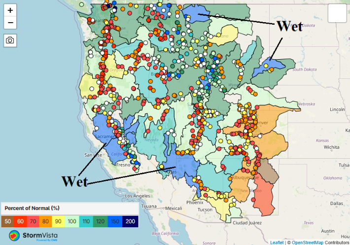
Historic warmth of the Northeast Pacific along the U.S. West Coast to Baja California is attributed to two climate patterns affecting NW/West HYDRO: 1.) Long duration dry high-pressure ridge (as expected during the next 3 weeks); 2.) Over-achieving precipitation producers as seen with the recent atmospheric river, a pattern that may return in February. 70% of the U.S. is affected by dry-to-drought conditions caused in-part by an 18-month La Nina climate as identified by multi-variate ENSO index. The outlooks for spring indicate significant drought potential for the southeast quadrant of the U.S.
01/08/2026, 3:48 pm EST

La Nina Ending Next 1-3 months Confidently Forecast. Entering “Springtime Prediction Barrier”

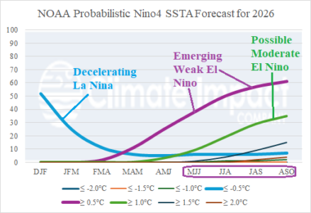
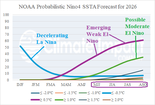
The equatorial subsurface East Pacific has warmed significantly and oceanic La Nina demise is ahead for late winter. La Nina climate is likely to last longer, lasting until mid-to-late spring. We’re entering the “springtime prediction barrier” for ENSO forecasts. Recent research has revealed that already low skill of ENSO forecasts made at this time of year has worsened.
01/08/2026, 5:00 am EST

Interior West/Northern U.S. and Florida are Windy Regions for Q1/2026

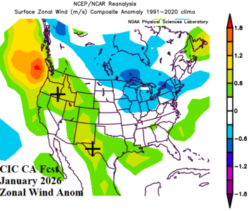
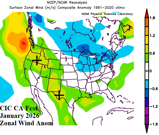
ECMWF and CIC-CA U.S. wind forecasts for JAN-26 to MAR-26 are compared to establish forecast confidence. Indicated are above average forecast confidence for greater than normal windspeeds Interior West for the current month with disagreement in the Southeast, especially Florida where ECMWF indicates lighter than normal windspeed and CIC-CA is above normal.
01/06/2026, 5:00 am EST

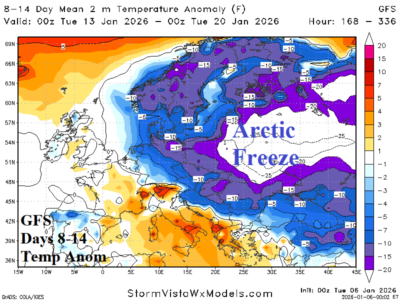
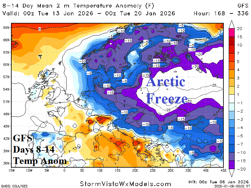
Cold Europe/Western Russia Pattern Ahead

The GFS 1-7-day forecast indicates expansive cold to very cold weather enhanced by widespread above normal snow cover. Both GFS and ECM agree that arctic air becomes involved in the 8-14-day period adhering to East Europe and West Russia. Snow cover is above normal as indicated by GFS for midday today and increases/deepens over the next 2 weeks.
01/05/2026, 3:07 pm EST

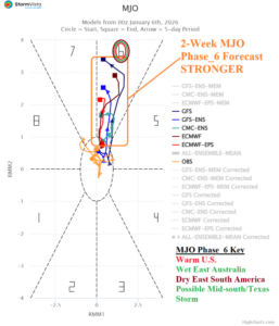
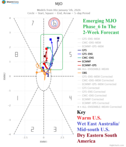
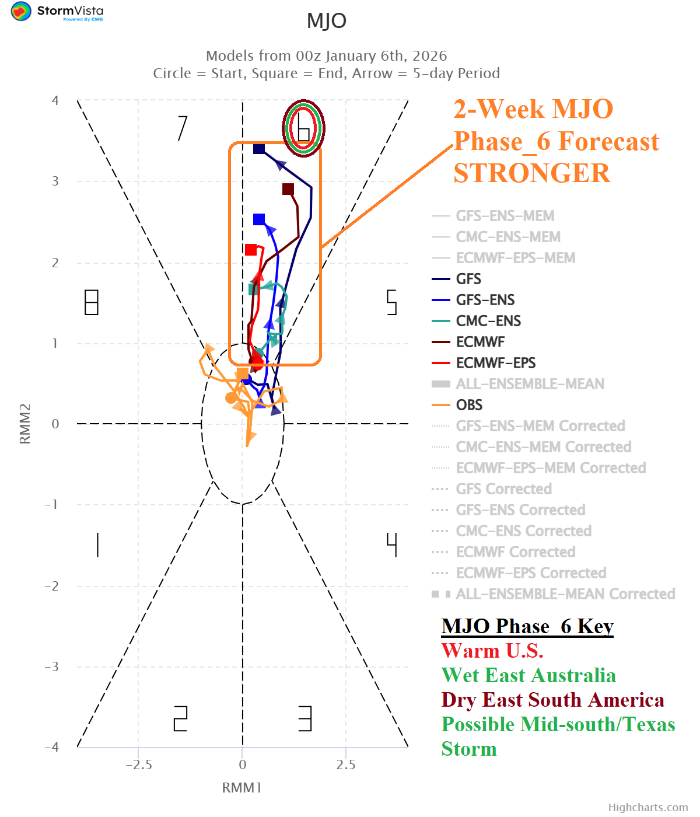
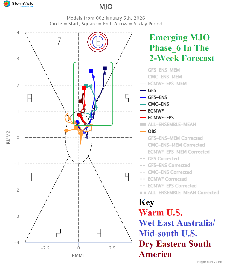
Madden Julian Oscillation Activates

The last pulse of convection phase Madden Julian oscillation (+MJO) was observed during November across the eastern tropical Indian Ocean to north of Australia. The event was immense, causing many late season tropical cyclones, and eventually a latent heat release poleward to the polar stratosphere. In December, the warming stratosphere shifted over Canada igniting an arctic outbreak. Since that time, MJO has been dormant. However, in a forecast change, the 2-week MJO forecast utilizing all models indicates a moderate intensity phase_6 of the +MJO develops which will cause several important impacts on weather and climate.