
NW HYDRO & The Northeast Pacific “Warm Blob”; U.S. Drought Monitor, Latest EDDI, and CAS Soil Moisture Outlook
01/09/2026, 5:29 am EST
El Nino Alert Ahead!
01/13/2026, 6:08 am EST![]()
Climate Impact Company Daily Feature
Issued: Sunday, January 11, 2026
Highlight: HDD forecasts have been too cold.
Discussion: Natural gas prices spiked around $5.31 during early December thanks to the heating demand forced upon the eastern half of the U.S.by an arctic outbreak. Since that time, arctic air gradually dissipated, and a much warmer regime has followed. Natural gas prices have plummeted to $3.17 at last check. Anticipating a cold pattern change has been in the extended range forecasts for a while mostly by week 4-5 AI projections. However, what became obvious last week is a rewarming stratosphere to drive arctic air generation in North America is increasingly unlikely during the next 6 weeks. Other warm climate forcings include the convection phase of the Madden Julian oscillation (MJO) shifting toward the Dateline and a warm (subsurface) Kelvin Wave shifting across the equatorial Pacific to kill-off La Nina by next month.
U.S. gas population weight HDD forecasts through 6 weeks from late December correctly identified the warmer early-to-middle January warmer trend although not as warm as observed (Fig. 1). Today’s projection for the current week is MUCH warmer than forecast in late December and possibly the largest reason for the natural gas price collapse. Projections for week-4 are near the 30-year normal, somewhat less cold than both CFS/ECM and AI indicated from 2 weeks ago. Today’s AI forecast for the week ending February 5th remains cold while ECM is much warmer, weighing down the CFS/ECM consensus.
Learned here is the 2025-26 winter pattern is reliant on the stratosphere to produce significant cold. In the absence of stratospheric warming, mild weather is present and can be extreme. Simply stated, the La Nina climate cannot, on its own produce significant cold in the U.S. (which is typical). The AI forecasts have a cold bias in the week 4-5-time frame. But not all AI models. Graph Cast is reasonable while AI 4CastNet V2 GFS ENS and ECM ENS are consistently much too cold.
Today’s forecast is super warm for this week and shifts colder to near normal to close January (Fig. 2). No arctic air for the U.S. is indicated. 4CastNet V2 GFS ENS/ECM ENS are cold for much of the U.S. week 4-5 ahead while Graph Cast is warmer. ECM is warm and CFS cold in the East for the extended range. The bottom line, MJO must shift past the American longitude to drive a colder U.S. pattern and while that scenario is possible forecasts are not seeing that potential (yet). Extended range forecasts are not projecting significant stratospheric warming to force arctic air development in North America, for now.
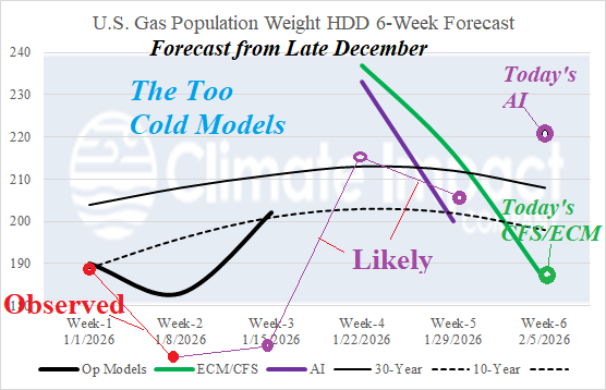
Fig. 1: The late December U.S. gas population weight 6-week HDD forecast utilizing all models through week-3 and estimates based on CFS/ECM consensus and 3 AI models for week 4-6. Observed and projected verification through week-5 and today’s week-6 forecast are added.
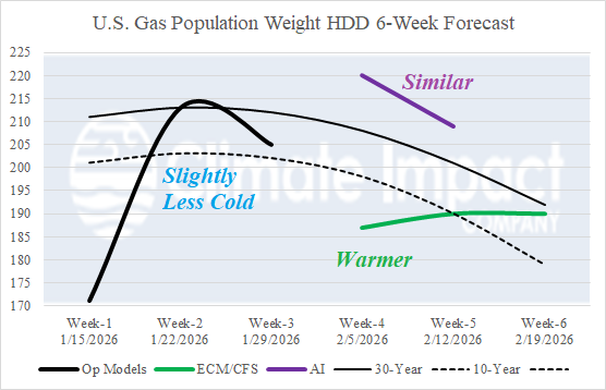
Fig. 2: Today’s U.S. gas population weight 6-week HDD forecast.