
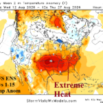
Explosive Heatwave/Flash Drought Mid-south/Southeast U.S. Ahead
08/12/2026, 5:06 pm EDT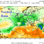
Beneficial Rainfall Cools off Europe
08/16/2026, 3:45 pm EDT
Climate Impact Company Europe/Western Russia Month 1-4 Ahead Outlook
Issued: Friday, August 14, 2026
Highlight: After marine heatwaves inspire summer 2026 heat and drought, Super El Nino is next for the last few months of 2026.
Executive summary: The catalyst to the Europe 2026 heat waves was rapid strengthening of record warm marine heatwaves off the West and Southwest Coast of Europe plus the Mediterranean Sea during late spring to early summer. While African heat (also) initiated the anomalous heat, MHW’s sustained the subtropical high pressure ridge maintaining heat waves through summer 2026. Up next is influence on climate by a record El Nino episode. In Europe, as the cool season arrives, the climate will shift wetter although staying warmer than normal into December. Chilly weather is confined to Western Russia during late autumn. The wet climate forecast for Q4/2026 will help to ease (but not end) the immense drought. El Nino is likely to bias Europe winter mild.
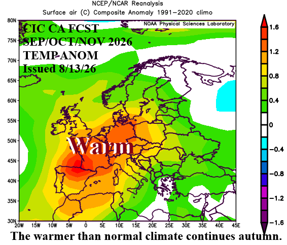
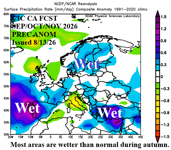
Fig. 1-2: Climate Impact Company SEP/OCT/NOV 2026 temperature and precipitation anomalies outlook.
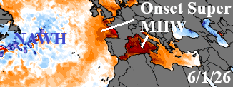
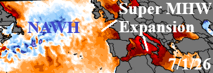
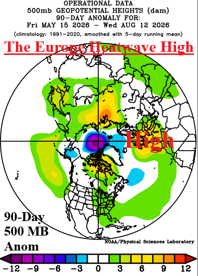
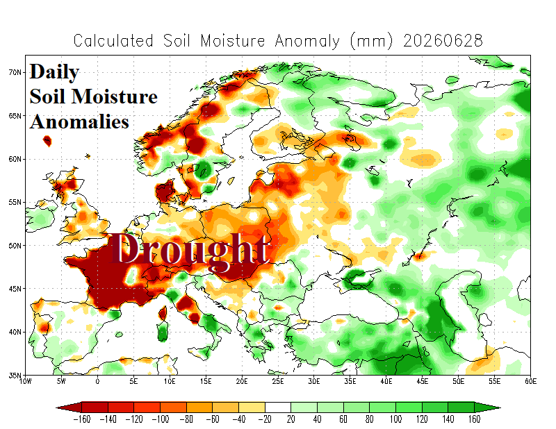
Fig. 3-6: SSTA analysis for June 1, 2026, and July 1, 2026, for areas surrounding Europe, the end of June soil moisture anomalies analysis across Europe, and 90-day northern hemisphere 500 MB anomalies regime.
Discussion: A fast-emerging marine heatwave (MHW) was observed in the western 2/3 of the Mediterranean Sea and off the West Coast of Europe by June 1st (Fig. 3). By early July, the warmest ocean surface on record was generated in this region (Fig. 4). Well-correlated to regions of strong MHW’s is the presence of amplified subtropical high pressure across and downwind from the MHW as observed during the past 90 days (Fig. 5). Beneath the semi-permanent high-pressure ridge, dry soils develop, and drought follows centered on France during late June (Fig. 6). The combination of semi-persistent high pressure and developing drought inspired many summer 2026 heatwave episodes across Europe (Fig. 7) biased toward Western Europe.
The monthly climate outlooks through the remainder of 2026 are inspired by development of the strongest El Nino on record, persistent MHW’s surrounding Europe, the North Atlantic warm hole (NAWH) south of Greenland and a developing positive phase of the Indian Ocean dipole (+IOD).
El Nino is somewhat reliable as a warming influence on Europe climate during the cool season. However, precipitation regimes are less reliable. During the 2026-27 cool season, due to warm waters surrounding Europe and across the subtropical North Atlantic (Fig. 8), over-achieving precipitation is favored and a welcome sight given the drought in place now. A strong NAWH pattern is forecast which favors a semi-permanent upper trough off the West Coast of Europe which could ramp up the storm track. Finally, +IOD favors anomalous convection in the western tropical Indian Ocean and areas just to the north. The anomalous convection could shape the upper air pattern across Western Russia with residual effects upstream through Europe.
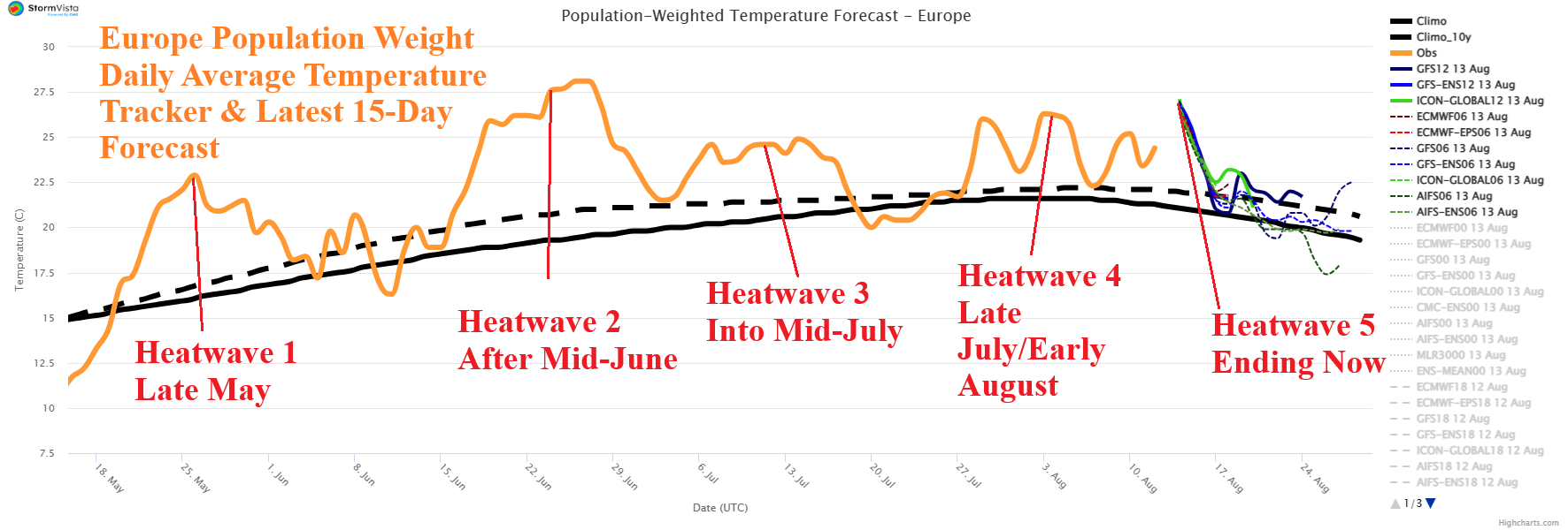
Fig. 7: Observed daily average temperature across Europe for the past 90 days and latest 15-day forecast.
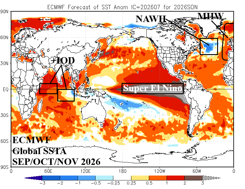
Fig. 8: Global SSTA forecast by ECMWF valid for SEP/OCT/NOV 2026.
September 2026 outlook: The CIC-CA forecast keeps Europe warmer than normal for late calendar summer. Operational “weeklies” forecast models indicate Northern Europe may be cooler, at least the first half of the month. Needed rainfall appears in Portugal and Spain and may reach Southern France. Wet weather is also forecast in Southeast Europe. Other areas stay dry and drought remains in an expansive mode. Northern Europe is quite wet. The Black Sea region is marginally drier and warmer than normal.
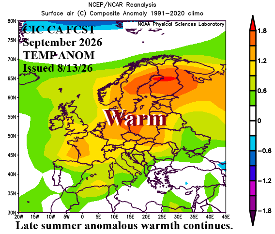
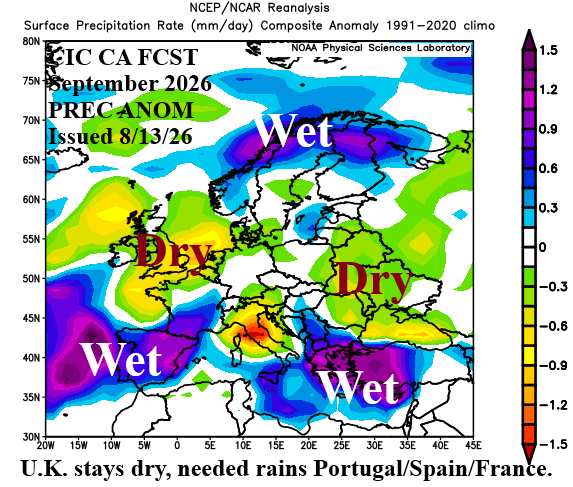
Fig. 9-10: Climate Impact Company September 2026 temperature and precipitation anomalies outlook.
October 2026 outlook: Similar with the Northeast U.S. during October, cool weather emerges in Eurasia during mid-meteorological autumn across Western Russia. However, anomalous warmth roars on for much of Europe. The wet shift in Southwest Europe during September continues in October. The wet streak across Northern Europe in September shifts south across the Baltic region in October and includes Northern Germany. Southeast Europe remains wetter than normal. Cooler than normal weather dips into the Black Sea region on occasion.
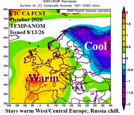
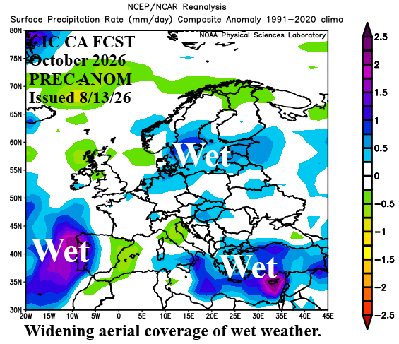
Fig. 11-12: Climate Impact Company October 2026 temperature and precipitation anomalies outlook.
November 2026 outlook: The wet climate influence of a buoyant El Nino appears across much of Europe during November. Only Italy escapes the storm track. The Black Sea region is wetter than normal. The storm track entrains additional moisture made available by MHW’s off the West Coast and across the Mediterranean Sea which is a mild influence on the temperature regime. Chilly weather remains across Northwest Russia.
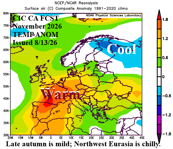
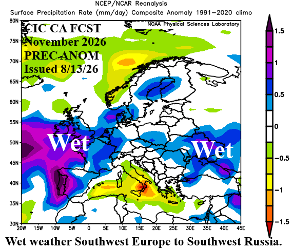
Fig. 13-14: Climate Impact Company November 2026 temperature and precipitation anomalies outlook.
December 2026 outlook: The mild El Nino influence combined with (mild) enhancement from MHW’s delivers a warm start to meteorological winter. The storm track lifts northward to Northwest Europe. Southern Europe is mostly drier than normal. The Black Sea region and Southwest Russia are also warmer than normal to start the winter season.
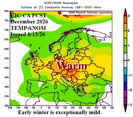
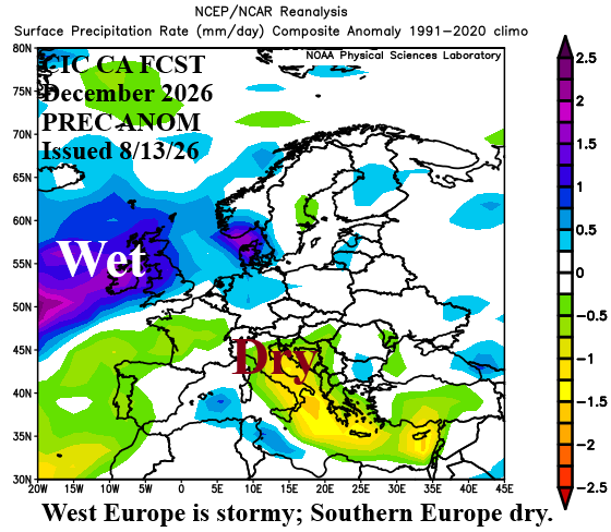
Fig. 15-16: Climate Impact Company December 2026 temperature and precipitation anomalies outlook.