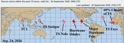
09/23/2026, 5:56 am EDT

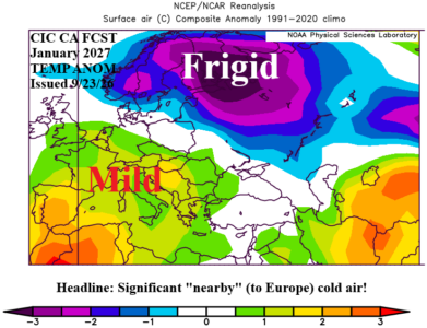
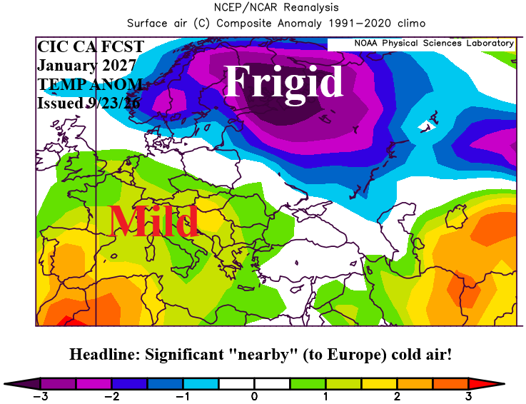
Mild Winter in Europe. But! Cold Periods in Western Russia to Track.

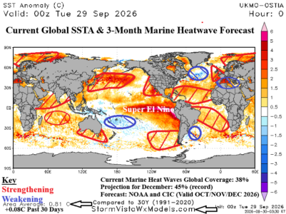
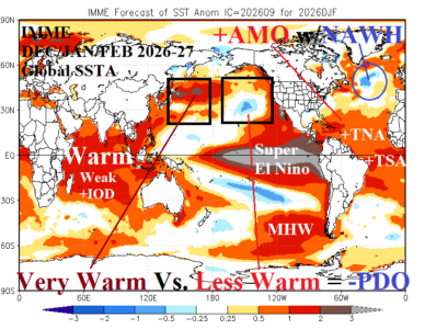
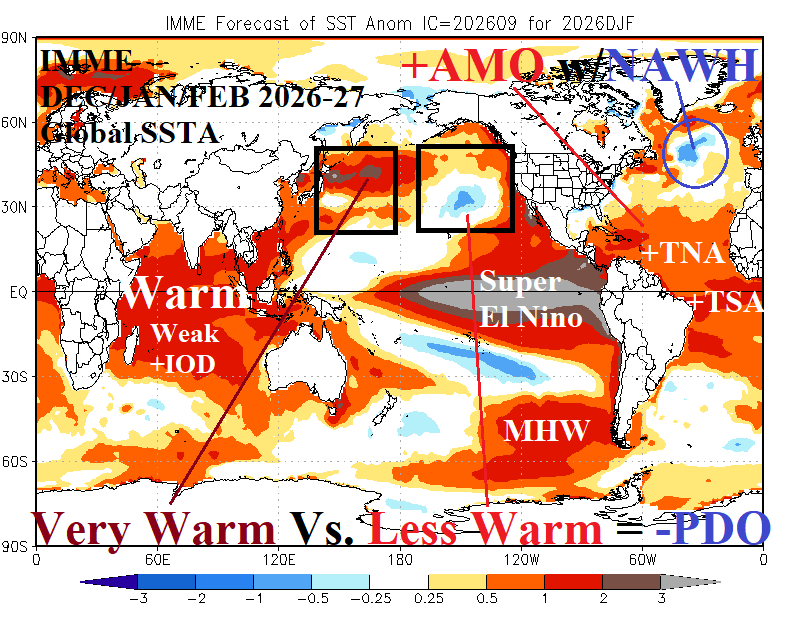
The Europe/Western Russia month 1-5 outlook is based on regional SSTA patterns affecting Europe particularly the East Pacific Super El Nino and resurgent North Atlantic warm hole south of Greenland. Favored is a mild winter across Europe. The risk of negative North Atlantic oscillation events causing cold weather regimes during the winter season is below normal. However, periods of cold and snow are likely in nearby Northwest Eurasia to Western Russia and will create periods when monitoring for cold from the east, especially in January, is important.
09/22/2026, 4:52 pm EDT

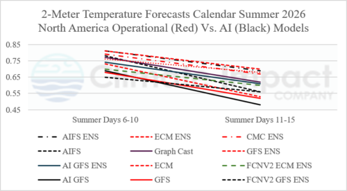
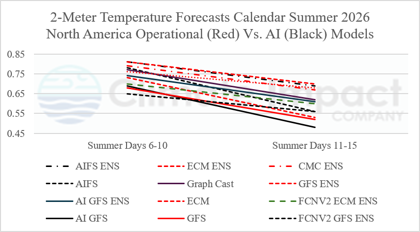
During Calendar Summer 2026. Operational Models Edge AI in Skill

Comparing 5 operational models with 7 AI models forecasting 2-meter temperature across North America utilizing CWG/SVWM anomaly correlation skill score (0 to 1 scale) during calendar-summer 2026 indicates operational models out-performed AI models by a small margin.
09/22/2026, 7:11 am EDT

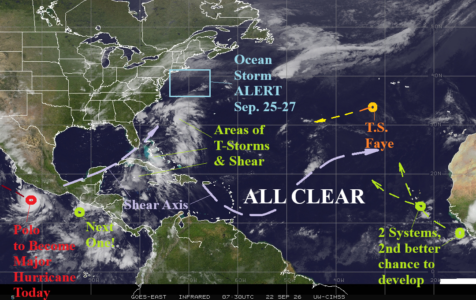
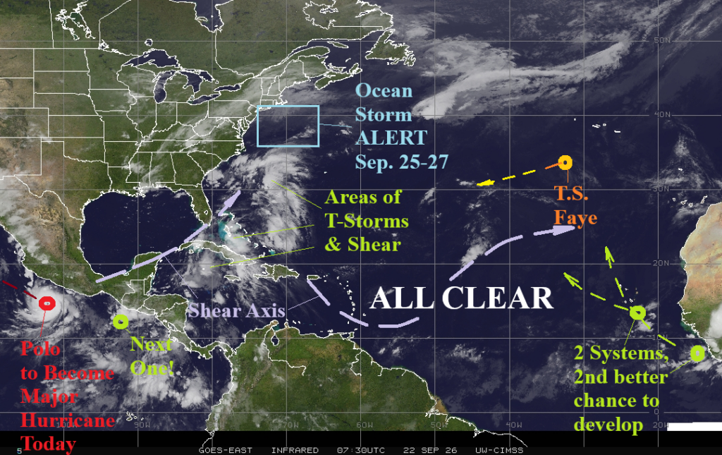
North Atlantic Tropics Busy With POTENTIAL Events

The North Atlantic basin remains quiet as (calendar) autumn begins. Upper shear streaks prevent organization of thunderstorm activity in the Bahamas and keep the central North Atlantic ALL CLEAR. Two tropical waves in the outer North Atlantic may organize while turning north, the second just entering the North Atlantic basin this morning, has the best chance. Tropical Storm Faye is barely discernable and weakens drifting west-to-southwestward.
09/21/2026, 3:43 am EDT

Strong +IOD Emerging; Lasts into Early 2027

The daily Indian Ocean Dipole (IOD) index is +1.01C indicating presence of strong positive phase which initiated several weeks ago although the Dipole Mode Index (DMI) was +0.68C for AUG-26 suggesting +IOD may have formed during later July. Australia Bureau of Meteorology indicates +IOD will continue through Q4/2026 with an average index of +0.8C rivaling 2023 (+09C), 2019 (+0.9C), 2018 (+0.6C), and 1997 (+1.2C). Only 2023 and 1997 +IOD regimes were concurrent with El Nino episodes.
09/20/2026, 7:42 pm EDT

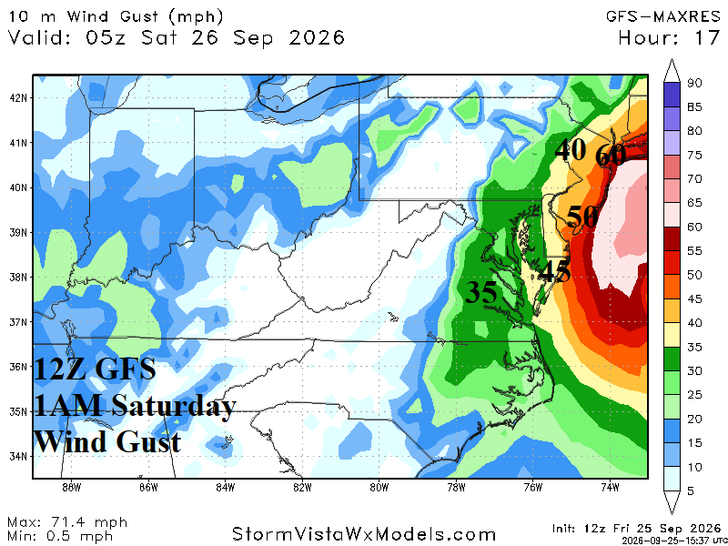
Late Week Northeast Corridor Coastal Storm!

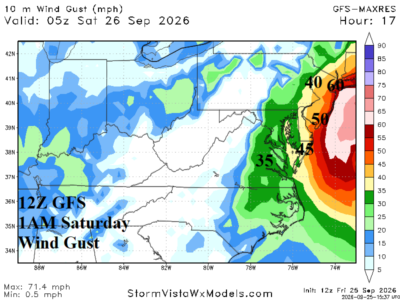
A cold front brings rain and sustains cool weather across the Northeast/Mid-Atlantic region this week. The front stalls offshore and a low-pressure system develop and stalls and then create a large swath of high wind, coastal flooding, and moderate-to-heavy rain for late week/next weekend most impressively projected by ECM.
09/20/2026, 7:40 pm EDT

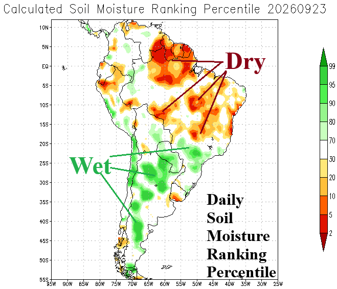
Southern Brazil Rains/Changeable Temperature across South America Into October

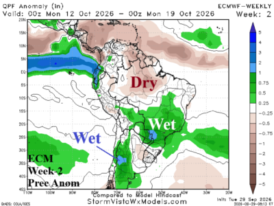
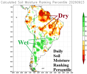
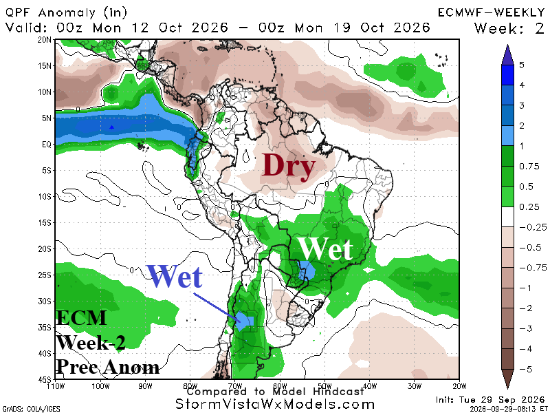
The 15-day outlooks are consistent with expansive wetter than normal conditions across Southern Brazil and Paraguay with ECM ENS the most aggressive (wet) forecast. Note that recent rainfall has been abundant through a narrow channel stretching from Northern Chile to central continent to the Brazil Southeast Coast. Either side of the wet weather very dry conditions have persisted.
09/16/2026, 8:46 am EDT

Overnight GFS and ECM Indicate a Potential 11-15-Day Gulf of America/Florida/Southeast U.S. Coast Problem

Overnight, both the GFS and ECM operational models project heavy rain associated with a tropical cyclone during the 11-15-day period in the Gulf of America and the Southeast U.S. Coast plus Florida. The 11-15-day forecast indicates potential for a high impact event gaining substantial confidence if the same projection is in the 6-10-day forecast late this weekend. GFS develops a system in the Northwest Caribbean Sea late next week and projects a stalling hurricane in the eastern Gulf of America during the last 5 days of the month. ECM develops a system in the Northeast Gulf during the 11-15-day period.
09/16/2026, 8:41 am EDT

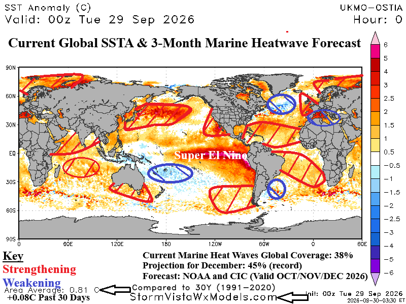
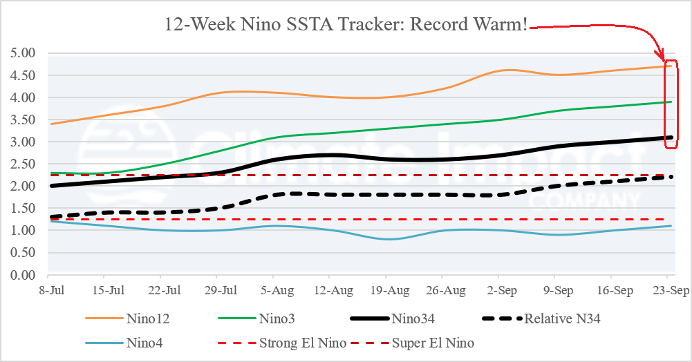
Strong to Super El Nino 2026 Continues to Strengthen

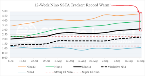
The NEW relative Nino34 SSTA index jumped to +2.0C last week and is nearing the +2.25C Super El Nino threshold. The conventional Nino34 index passed the Super El Nino threshold several weeks ago. El Nino continues to intensify.
09/15/2026, 9:19 am EDT

Glance at U.S. Population Weight HDD Forecasts for NOV-26 to MAR-27

The initial U.S. gas population weight HDD forecast for the 2026-27 cold season reveals a mild regime with each month forecast below the 10-year/30-year climatology. Regionally, all zones are warmer than normal for NOV-26 to MAR-27 except near the 10-year normal for Texas.
09/13/2026, 12:11 pm EDT

Latest Multivariate ENSO Index Report

The JUL/AUG 2026 multivariate ENSO index (MEI) was +2.5. MEI is an excellent indicator of the atmospheric response to the equatorial Pacific Ocean sea surface temperature anomaly (SSTA) regime. When comparing the JUL/AUG 2026 MEI with the past 3 previously most intense El Nino episodes on record, the 2026 signature ranks strongest. Note that after rapid intensification of previous strong El Nino events, there is a tendency of MEI to level off except for the 1982-83 event which peaked in strength well into the second year of the event.