
Southern Brazil Rains/Changeable Temperature across South America Into October
09/20/2026, 7:40 pm EDT
Drought Concern (in Australia Crop Areas) Increasing
09/25/2026, 8:50 am EDT
Climate Impact Company Europe/West Russia Month 1-5 Outlook
Wednesday September 23, 2026
Highlight: Mild winter in Europe. But! Cold periods in Western Russia to track.
Executive summary: The Climate Impact Company month 1-5 ahead forecast us updated and includes meteorological winter (Fig. 1-2). The outlook is based on regional SSTA patterns affecting Europe particularly the East Pacific Super El Nino and resurgent North Atlantic warm hole south of Greenland. Favored is a mild winter across Europe. The risk of negative North Atlantic oscillation events causing cold weather regimes during the winter season is below normal. However, periods of cold and snow are likely in nearby Northwest Eurasia to Western Russia and will create periods when monitoring for cold from the east, especially in January, is important.
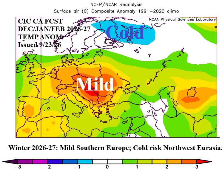
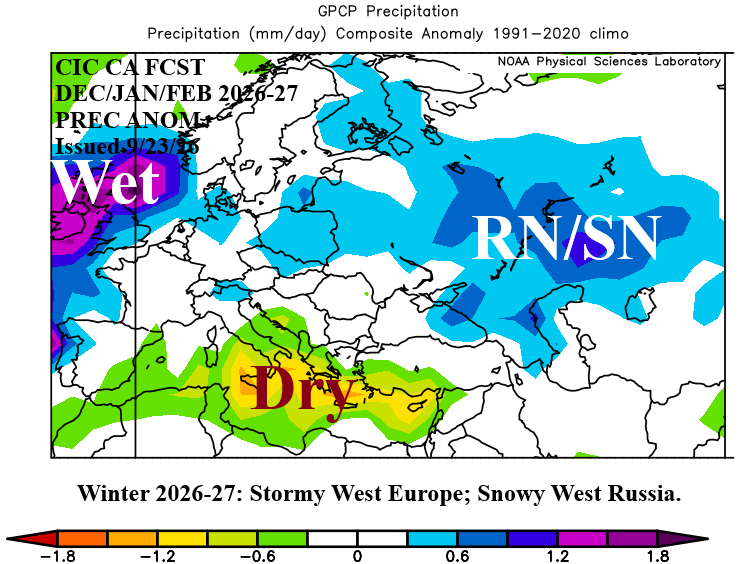
Fig. 1-2: The Climate Impact Company constructed analog DEC/JAN/FEB 2026-27 temperature and precipitation anomalies outlook for Europe and West Russia.
Climate discussion: The Europe/West Russia month 1-5 outlook is based on climate correlation to evolution of Super El Nino, strong marine heatwaves (MHW) surrounding Europe, and resurgent North Atlantic warm hole (NAWH). Additionally, a look at the most likely North Atlantic oscillation (NAO) phase, given Super El Nino, is reviewed.
The daily Nino34 SSTA index, where ENSO phase intensity is measured, continues to warm and is at a record +3.14C. Additional warming is anticipated during Q4/2026. The Mediterranean Sea MHW remains strong although weaker than one month ago. MHW’s off the west/southwest coast and to the north of Europe remain vividly present with not much change in strength during late calendar summer. NAWH is redeveloping rapidly, displaced farther west, off the coast of Newfoundland. The ECMWF global SSTA forecast for OCT/NOV/DEC 2026 (Fig. 3) reveals each feature described maintained with NAWH budging eastward to do south of Greenland. During October and November, a chart to watch is the northern hemisphere snow cover, which during the past 10-15 years has shown above normal snow cover in Northern Eurasia due to early season cold winds across open ocean to create advection snow. The early look on this new phenomenon is above normal snow cover is already forming in Northeast Russia (Fig. 4). The warm SSTA pattern will bias climate mild while evolving snow cover enables early season cold air to pool in Russia which if sustained can shift westward into Europe given negative North Atlantic oscillation (-NAO). During the 5 strongest El Nino episodes on record during OCT/NOV/DEC, the NAO pattern has favored greatest risk of -NAO in October to greatest risk of +NAO in December (Fig. 5). +NAO is (also) favored during February. +NAO regimes favor milder winter climate across Europe.
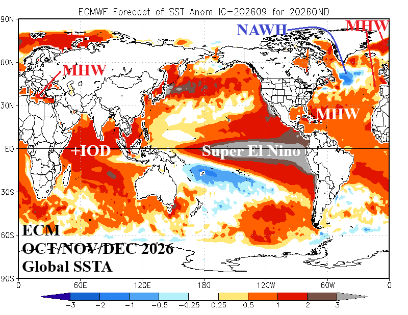
Fig. 3: ECMWF global SSTA forecast for January 2027, and regions of influence used in a constructed analog for Europe/Western Russia winter 2026-27 climate.
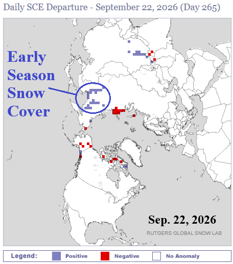
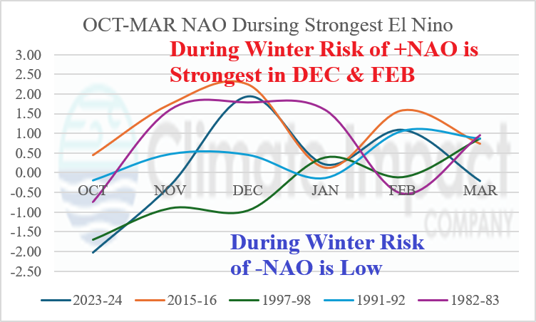
Fig. 4-5: Above normal early season snow cover is developing in Northeast Russia and the OCT-MAR North Atlantic oscillation indices during the 5 strongest El Nino episodes.
October 2026: Operational models are warm for the front end of October and cooler later in the month. The constructed analog favors the cooler regime developing more rapidly. Storminess drives the cooler change mid-to-late October most notably in Western Russia. France and Spain drought areas persist staying warmer than normal.
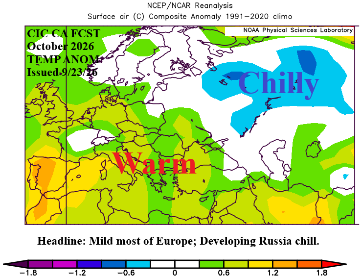
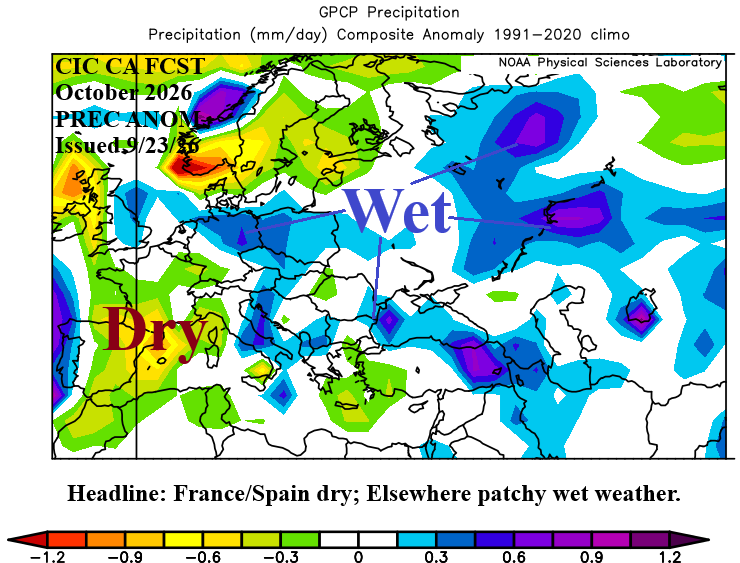
Fig. 6-7: The Climate Impact Company constructed analog October 2026 temperature and precipitation anomalies outlook for Europe and Western Russia.
November 2026: Late meteorological autumn is stormy and beneficial to easing the Europe drought. Gradually, Western Russia gains snow cover and possibly colder temperatures later in the month. Most of Europe stays warmer than normal during a rainy month.
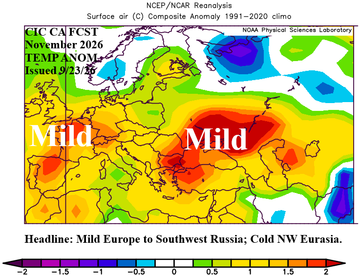
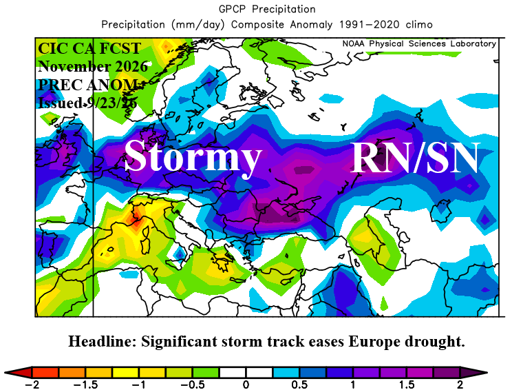
Fig. 8-9: The Climate Impact Company constructed analog November 2026 temperature and precipitation anomalies outlook for Europe and Western Russia.
December 2026: Europe is mild starting meteorological winter 2026-27. However, snow cover could force colder than forecast temperatures in Western Russia. Strong storm track brings wind and rain to U.K. while Southern Europe is dry and mild.
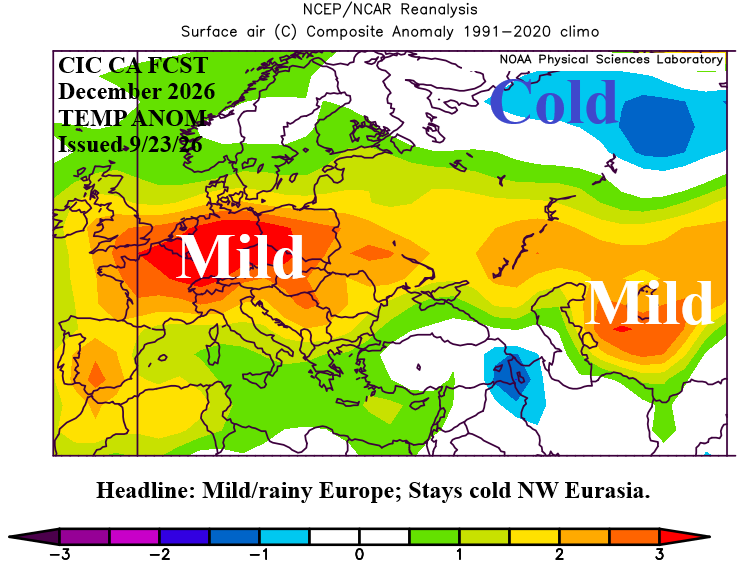
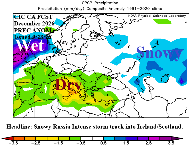
Fig. 10-11: The Climate Impact Company constructed analog December 2026 temperature and precipitation anomalies outlook for Europe and Western Russia.
January 2027: Mid-winter indicates a frigid air mass over Northwest Eurasia. The nearby cold to Europe is a dangerous set-up. Snow cover should increase substantially in Western Russia to Eastern Europe. If -NAO develops, the cold unloads on Europe. However, for now, -NAO is not expected during mid-winter.
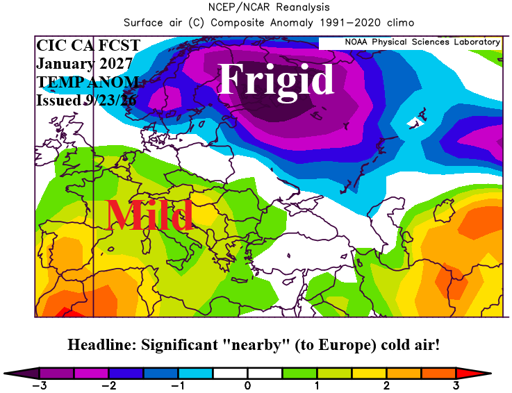
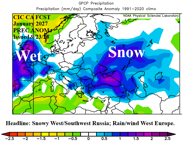
Fig. 12-13: The Climate Impact Company constructed analog January 2027 temperature and precipitation anomalies outlook for Europe and Western Russia.
February 2027: Late meteorological winter favors +NAO and a mild Europe regime. Tendency for a stronger than normal storm track continues featuring mostly rain across Europe.
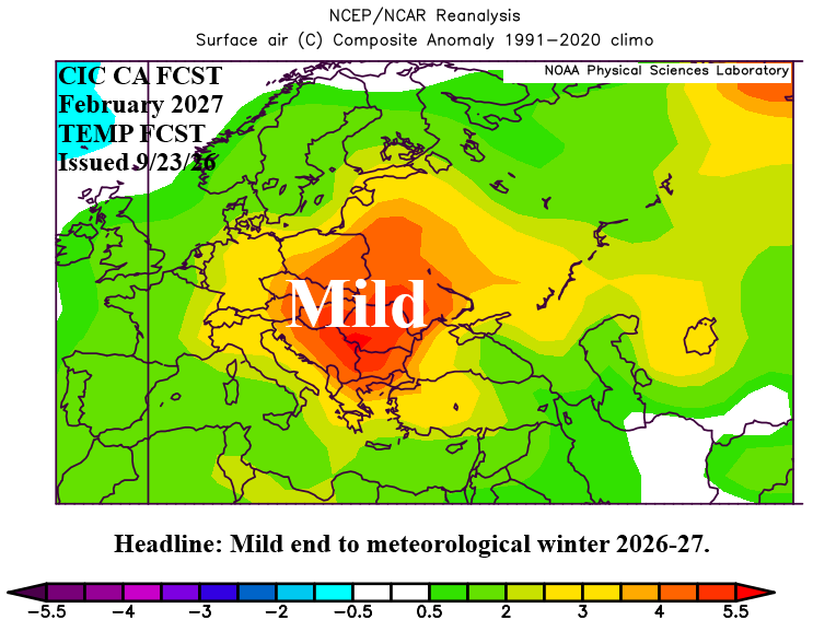
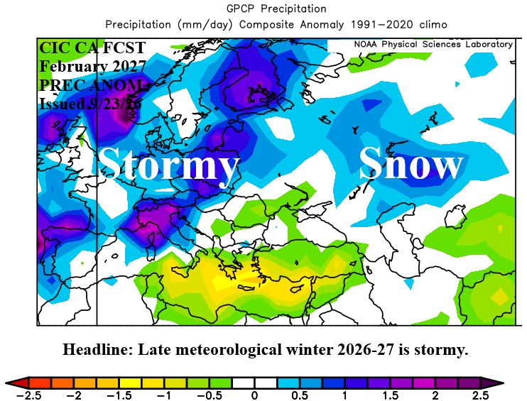
Fig. 13-14: The Climate Impact Company constructed analog February 2027 temperature and precipitation anomalies outlook for Europe and Western Russia.