11/22/2026, 1:55 pm EST

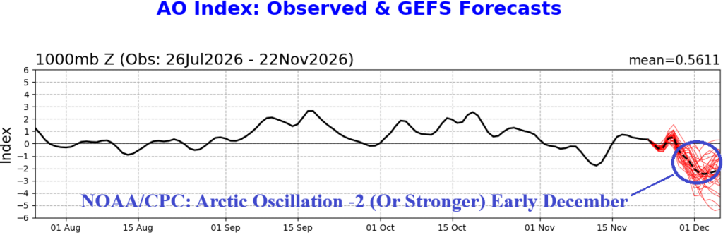
NOAA/CPC: Emerging Negative Arctic Oscillation Next Week

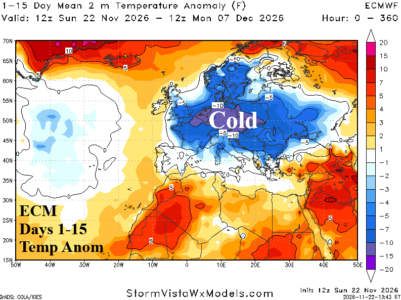
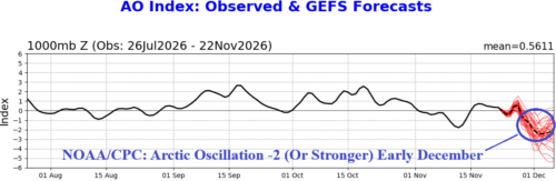
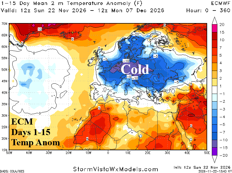
Of interest, is an emerging strong negative phase arctic oscillation (-AO) in the 8-14-day period. -AO represents high latitude high pressure blocking forcing the polar vortex southward to cause mid-latitude chill. This time, North America ais left out while the Europe forecast has been shifting colder.
11/20/2026, 9:10 am EST

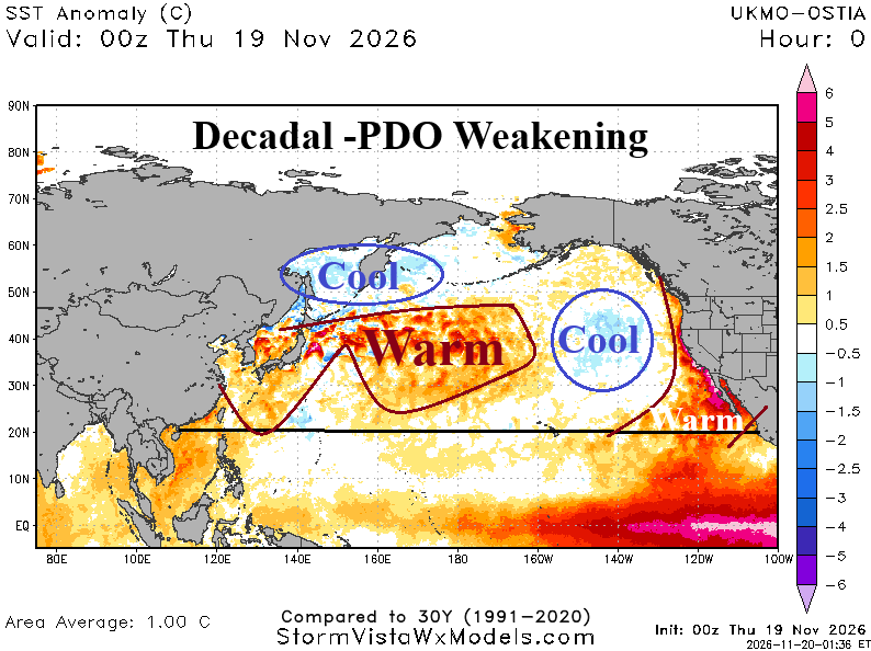
Long Standing -PDO Finally Weakening?

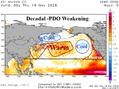
The Pacific decadal oscillation (PDO) has averaged -1.65 during 2026 so far. The ongoing strong negative phase, present this entire decade, is produced differently than past long duration -PDO regimes. Historically, a warmer northwestern Pacific Ocean than the northeastern Pacific Ocean creates -PDO.
11/20/2026, 9:07 am EST

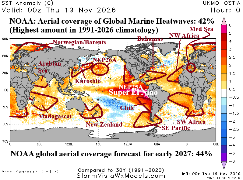
Record Aerial Coverage of Global Marine Heatwaves

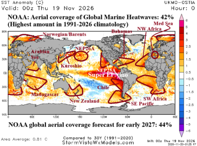
According to NOAA, global aerial coverage of marine heatwaves (MHW) has reached 42% according to a mid-November report which is the highest amount in the 1991-2026 period of record. The 3-month forecast valid during boreal winter is an increase to 44%. 2026 has already produced a record warm global sea surface temperature (SST), part of an ongoing trend of accelerating warmth observed during the past decade.
11/20/2026, 9:04 am EST

Major Storms Ahead! Snowstorms Included!

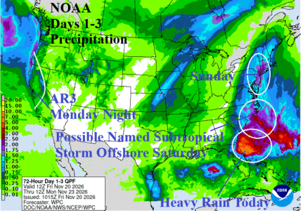
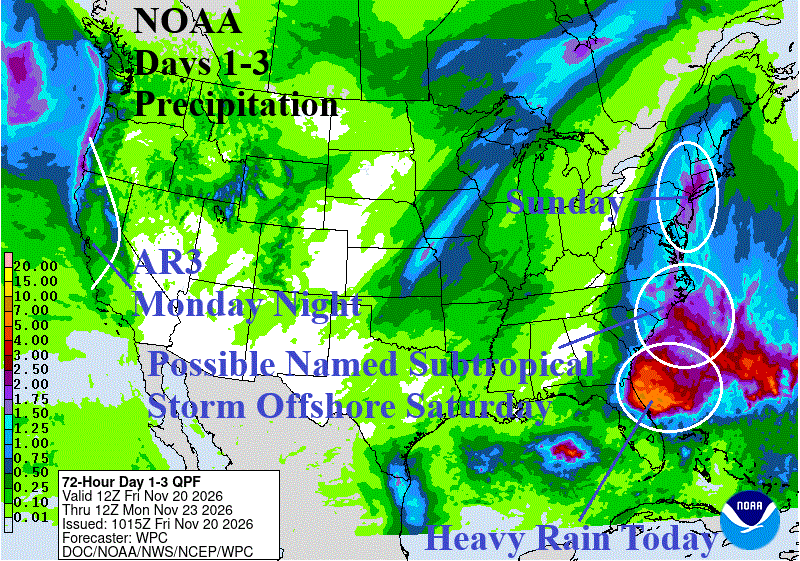
Low pressure develops off the Florida Coast today and coupled with strong wind gradient to the north causes a rain and windstorm into the east and northeast coast of Florida gradually working northward along the Southeast Coast tonight and Saturday. Deepening low pressure over very warm ocean temperatures enhanced by the Gulf Stream suggest a subtropical storm may form on Saturday. NOAA/NHC indicates 50% risk. The rain areas shifts northward unloading possible flooding rain on the Interior Northern Mid-Atlantic to southwest New England on Sunday.
11/19/2026, 11:55 am EST

Latest NOAA/CPC Long-lead Forecast for Winter

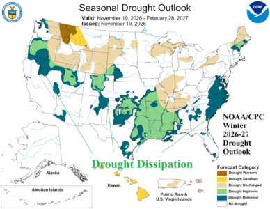
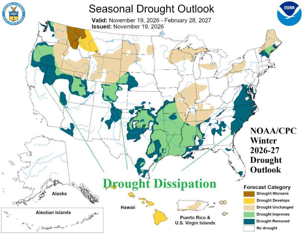
New long-lead NOAA/CPC climate forecasts for the winter season emphasize a Southern U.S. storm track which eases or eliminates drought across the southern half of the U.S. according to the latest seasonal drought outlook.
11/19/2026, 11:50 am EST

Subtropical Storm May Form Off Southeast U.S. Coast This Weekend

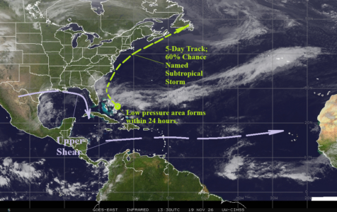
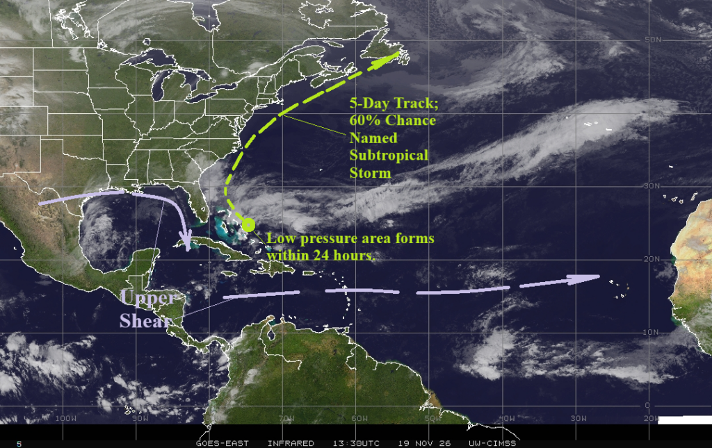
An area of low pressure is forecast to develop east of the Bahamas within 24 hours. This system drifts northwestward as the weekend approaches toward the Southeast U.S. Coast turning northeastward late weekend and accelerating toward the northeast just missing Cape Cold early next week. NOAA/NHC indicates 60% chance of a named subtropical storm by this weekend.
11/19/2026, 4:31 am EST

NAWH North Atlantic Low-pressure Trough Pattern Exceptionally Strong Winter 2026-27; Stormy West Europe, Mild Elsewhere

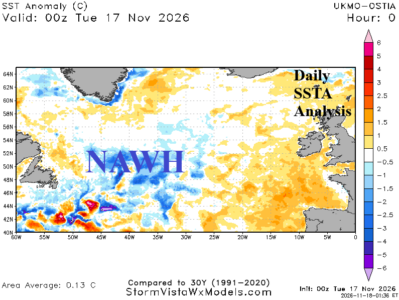
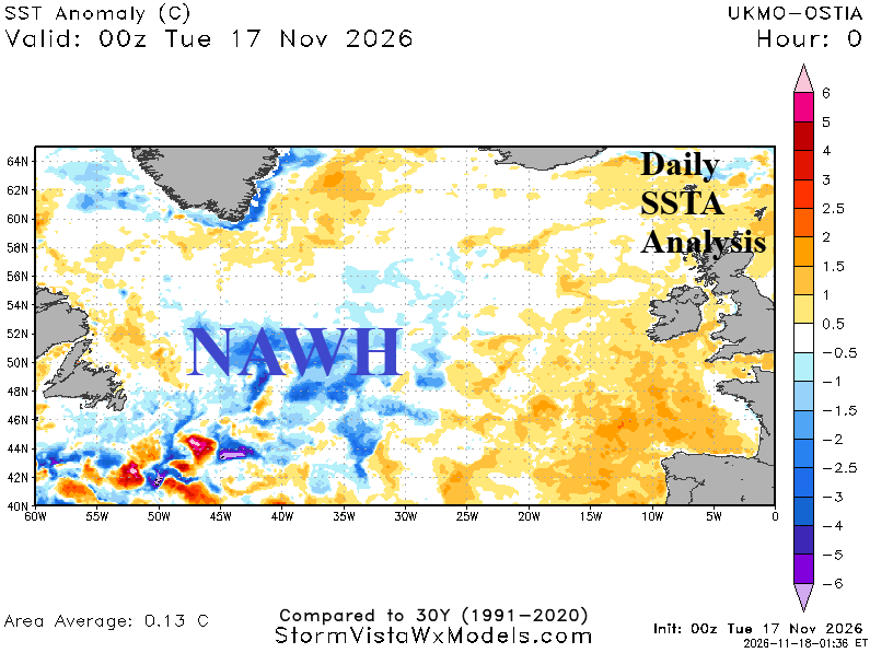
During the past dozen years, evolution of the North Atlantic warm hole has forced a semi-permanent upper air pattern on average promoting anomalous high pressure across Europe leading to increased frequency of hot/dry summer regimes and mild winter seasons. Strength of the NAWH projected for 2026-27 rivals the strongest mid-winter signatures of the 12-year period.
11/18/2026, 4:38 am EST

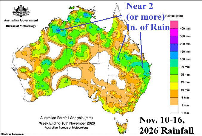
On Again/Off Again Wet Pulses across Australia

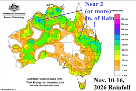
The most likely explanation for the on again/off again wet tendency in Australia is related to strong positive global atmospheric angular momentum (+GLAAM) present during El Nino and responsible for stronger than normal mid-latitude upper air flow. Occasionally, upper troughs embedded within the stronger than normal mid-latitude jet stream extend northward to deliver rain to Australia.
11/17/2026, 5:57 am EST

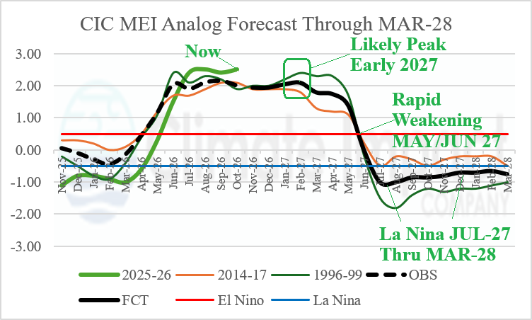
La Nina 2027-28? What Does U.S. Climate Look Like?

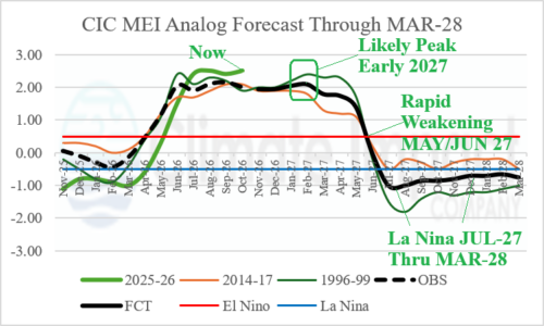
Multivariate ENSO index (MEI) is running stronger than the constructed analog (CA) as the end of 2026 approaches. The MEI CA forecast is similar with other ENSO forecasts maintaining the record intensity of late 2026 into early 2027. However, the speed of decay is impressive as the CA forecast not only weakens El Nino quickly but reverses to La Nina by June 2027. The NOAA/CPC ENSO phase probability forecast also increases La Nina risk by JUN/JUL/AUG 2027.
11/17/2026, 5:49 am EST

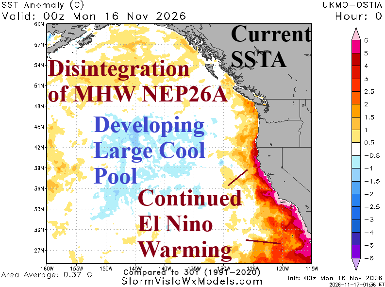
Developing Cool Pool in Northeast Pacific Shapes North America Winter Pattern

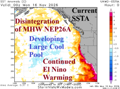
Northeast of Hawaii and south of the Gulf of Alaska, an area of cool sea surface temperatures (SSTA) is developing clearly identified within the 30-day change. Aloft, the large area of cooling ocean waters is well-correlated with a persistent upper trough stretching from the Aleutian Islands toward the California Coast. Given the rate of cooling and the persistent upper trough pattern, Climate Impact Company expects the cool SSTA/upper trough pattern to persist and intensify through meteorological winter.
11/15/2026, 9:24 am EST

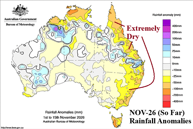
Eastern Australia Shifts Dry After Wet October

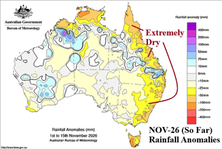
After an extremely dry East/Southeast Australia pattern during September, Northeast/East Australia turned prohibitively wet in October. The first half of November reverses drier in the East (again). Are conventional operational models understanding the drier reversal in Eastern Australia? No! All models (ECM pictured) are much too wet in Eastern Australia with daily 15-day forecasts.