
Developing Cool Pool in Northeast Pacific Shapes North America Winter Pattern
11/17/2026, 5:49 am EST
Climate Impact Company Research
Issued: Thursday November 19, 2026
NAWH North Atlantic low-pressure trough pattern exceptionally intense winter 2026-27; Mild influence on Europe and stormy West Coast.
Executive summary: During the past dozen years, evolution of the North Atlantic warm hole has forced a semi-permanent upper air pattern on average promoting anomalous high pressure across Europe leading to increased frequency of hot/dry summer regimes and mild winter seasons. Strength of the NAWH projected for 2026-27 rivals the strongest mid-winter signatures of the 12-year period. The influence of the NAWH pattern on Europe climate during winter 2026-27 is typically a prohibitive upper trough near the Europe West Coast producing significant coastal storms and milder than normal temperature farther downstream across most of Europe.
Discussion: The North Atlantic warm hole (NAWH) is intact (Fig. 1) and forecast to remain prominent through meteorological winter 2026-27 (Fig. 2). The NAWH pattern evolved with intensity about 12 years ago, was intense during mid-winter 2014-16 followed by variable intensity the remainder of last decade and weakening substantially 2 years ago before resurgence last mid-winter (Fig. 3). The strength of the NAWH pattern during mid-winter 2026-27 is projected to rival the strongest signatures observed middle of last decade.
The NAHW pattern is well-correlated with upper-level 500 MB low-pressure troughs across and/or downstream the cool pool of water with compensating upper-level ridging to the east (Fig. 4). The tendency for high pressure over Europe helps to explain the increased frequency of summertime anomalous heat and drought and generally mild winters.
The stronger mid-winter NAWH regimes observed during 2014-16 and 2019-21 have, on average, yielded a semi-permanent deep upper trough just west of Europe during meteorological winter (Fig. 5). The attendant sensible weather has featured slightly milder than normal Europe climate during winter (Fig. 6) and a prohibitive storm track (Fig. 7). The winter pattern attributed to the NAWH regime is generally not affected by ENSO phase.
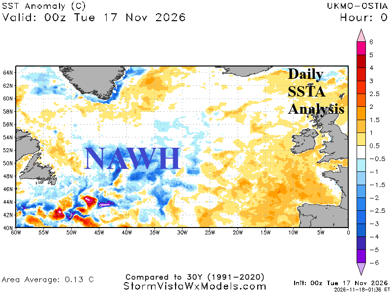
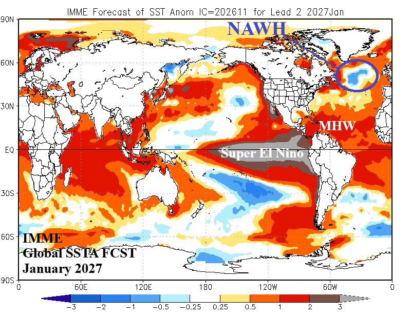
Fig. 1-2: Current SSTA analysis identifying the North Atlantic warm hole south of Greenland and the IMME global SSTA forecast for January 2027.
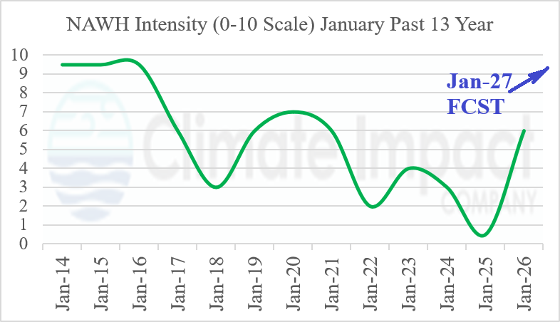
Fig. 3: Climate Impact Company estimated strength, based on 0-10 scale, of the North Atlantic warm hole during January 2014-26.
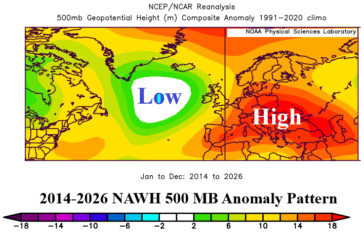
Fig. 4: Annual 500 MB anomalies analysis 2014-26 for the North Atlantic Ocean and Europe.
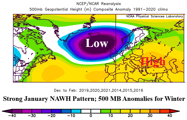
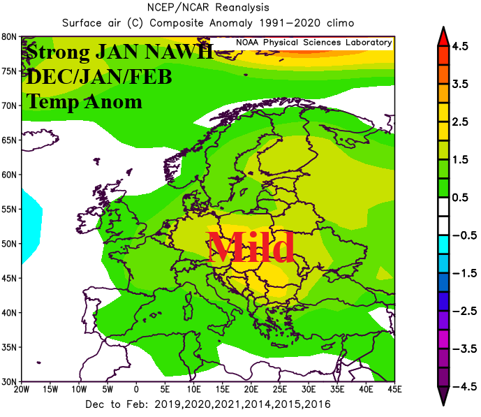
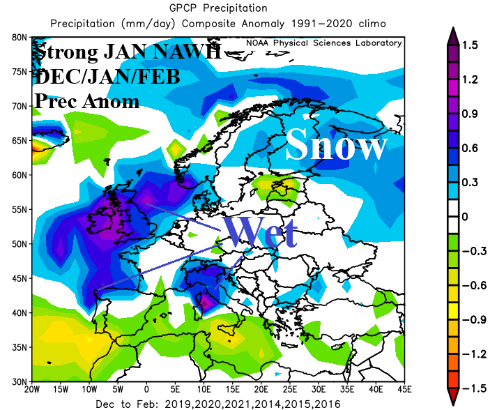
Fig. 5-7: Annual 500 MB anomalies analysis combining winter seasons of 2013-14, 2014-15, and 2015-16 plus 2018-19, 2019-20, and 2020-21 and the attendant temperature and precipitation anomalies.