
Recent Forecasts Are Too Wet for South America; Will Wet 15-Day Forecast Fail?
11/13/2026, 6:04 am EST
Climate Impact Company Year-2 Outlook
North America
Issued: Monday, November 16, 2026
Highlight: Given La Nina and continued anomalous warm oceans, mild-to-warm-to-hot bias remains in U.S. climate forecasts for 2027-28.
Discussion: Multivariate ENSO index (MEI) is running stronger than the constructed analog (CA) as the end of 2026 approaches (Fig. 1). The MEI CA forecast is similar with other ENSO forecasts maintaining the record intensity of late 2026 into early 2027. However, the speed of decay is impressive as the CA forecast not only weakens El Nino quickly but reverses to La Nina by June 2027. The NOAA/CPC ENSO phase probability forecast also increases La Nina risk by JUN/JUL/AUG 2027 (Fig. 2). One influence on ENSO which is new and not yet well understood is the accelerated warming of all oceans. The warming trend of this century has accelerated in this decade (Fig. 3) and coupled with an optimum climate normal (OCN) for this decade and a La Nina shift, an estimate of what summer 2027, autumn 2027, and winter 2027-28 is provided.
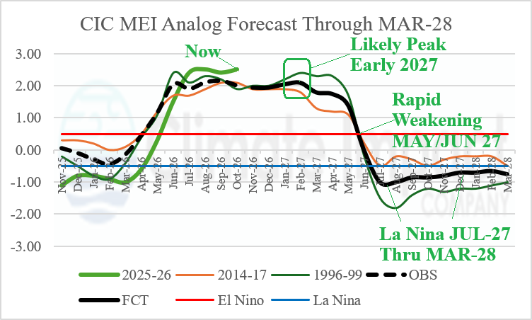
Fig. 1: Climate Impact Company constructed analog forecast for ENSO phase through March 2028 utilizing multivariate ENSO index.
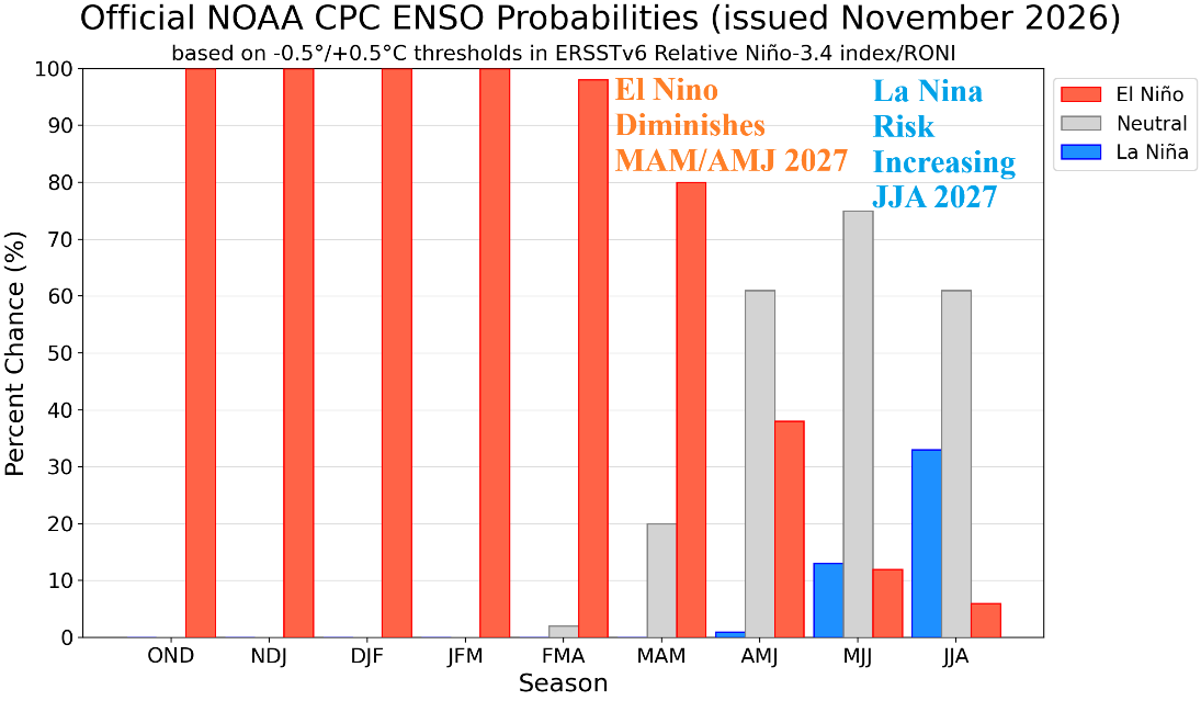
Fig. 2: The ENSO phase probability forecast from NOAA/CPC valid through JUN/JUL/AUG 2027.
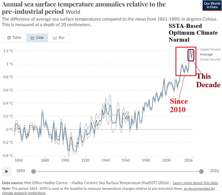
Fig. 3: The global ocean surface is warming with an accelerated rate during the past decade.
JUN/JUL/AUG 2027: Next summer regenerates anomalous heat risk in the classic Southwest U.S. source region frequently expanding eastward into the Southeast States and eventually the Northeast (Fig. 4). The Midwest heat risk is suppressed by heavy rain while the driest climate for next summer is across the Southeast States and reaching the Mid-Atlantic region (Fig. 5).
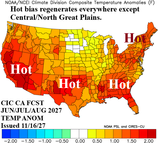
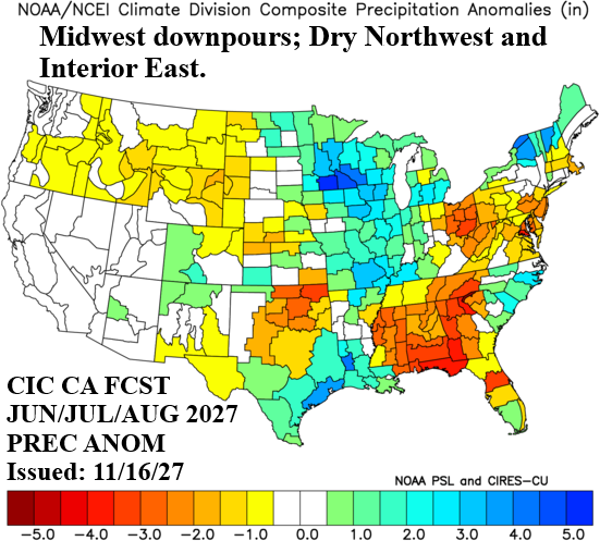
Fig. 4-5: The CIC-CA temperature and precipitation anomalies forecast for JUN/JUL/AUG 2027.
SEP/OCT/NOV 2027: The warm influence of mid-latitude oceans appears strongest during the autumn season (Fig. 6). An extremely warm autumn 2027 (except the West Coast) is projected next year. In the East, dryness (and heat) favors drought (Fig. 7). Heavy rain is forecast on the Northwest U.S. Coast. Despite La Nina and a warm North Atlantic SSTA pattern, limited risk of tropical cyclones is indicated in the Gulf region or Atlantic Seaboard.
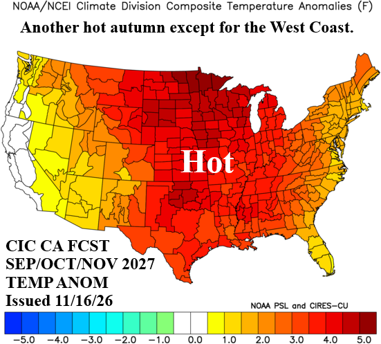
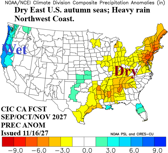
Fig. 6-7: The CIC-CA temperature and precipitation anomalies forecast for SEP/OCT/NOV 2027.
DEC/JAN/FEB 2027-28: The winter season is mild except cold and stormy Northwest (Fig. 8-9). Much of the East is drier than normal. Warmest temperatures anomalies are across the South States and Upper Midwest.
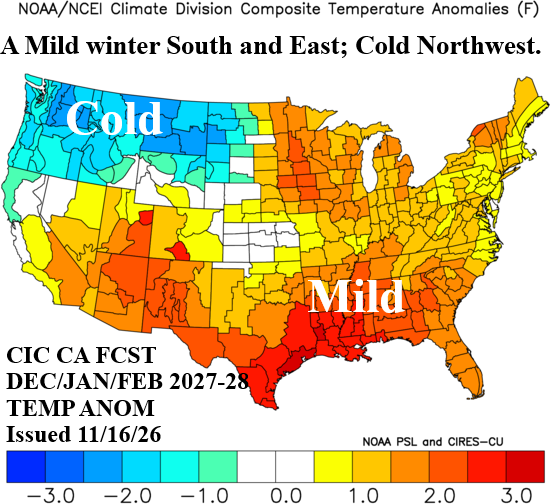
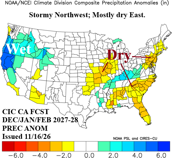
Fig. 8-9: The CIC-CA temperature and precipitation anomalies forecast for DEC/JAN/FEB 2027-28.