04/29/2025, 4:32 pm EDT

Adding The East for Heavy Rain Next Week?

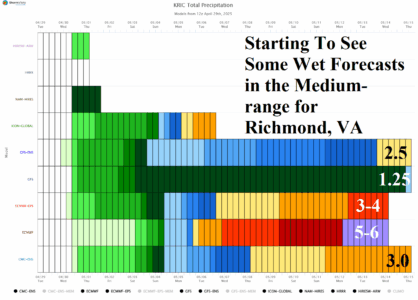
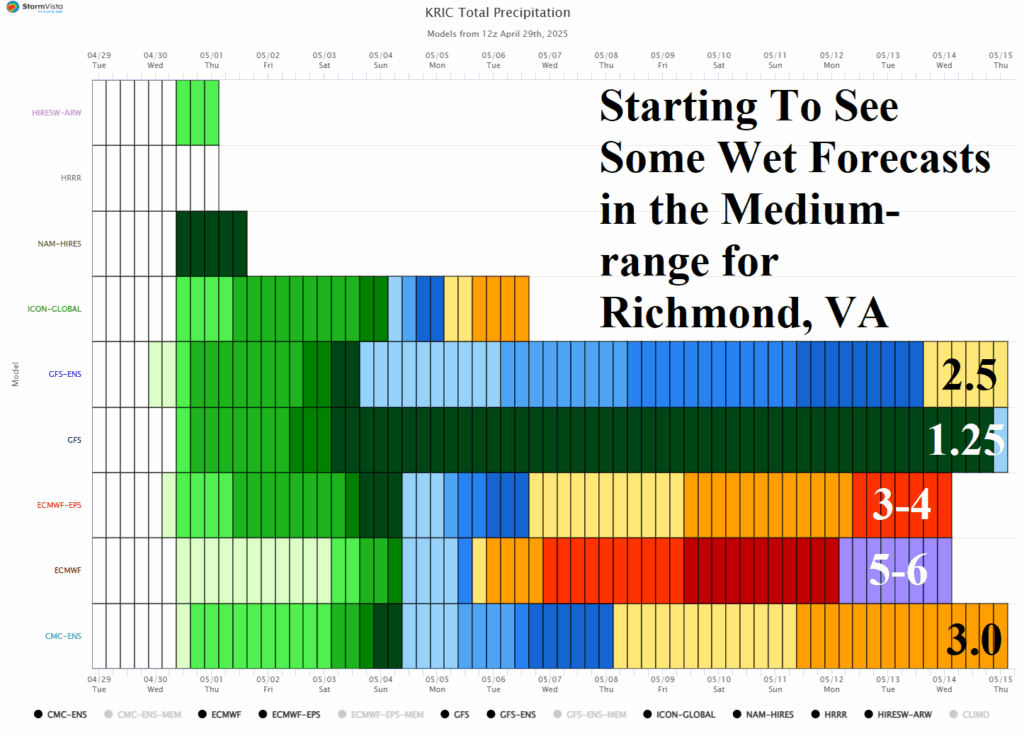
Next week, the ECM is forecasting a low-pressure area to cutoff in the East causing a potential excessive rainfall episode in the Mid-Atlantic States. Using Richmond, VA as an example, rainfall could accumulate to 5-6 in. according to ECM while other models (GFS and GFS ENS) are not nearly as wet.
04/29/2025, 4:23 pm EDT

Excessive Rain/Flooding Southern Plains/Texas

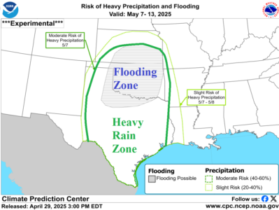
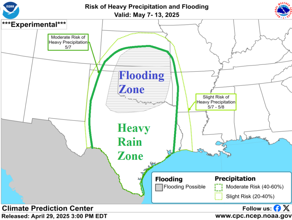
Ongoing flooding in Oklahoma to Texas will intensify as another 7-10 inches of rain is possible over the next 1-2 days. River flooding, travel hazards, power outages, and crop damage increase. A second event is likely next week! The hardest hit area for flooding is Oklahoma likely to exceed the intensity of the Ohio/Mississippi River flooding event of early April.
04/29/2025, 6:03 am EDT

An Update On Regional SSTA Across The North Atlantic Basin

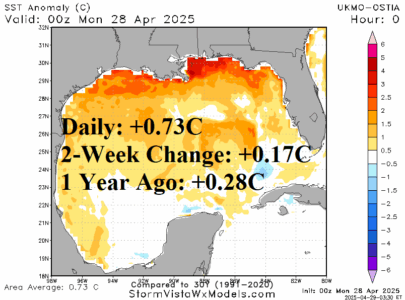
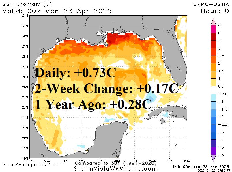
The Gulf of Mexico is very warm at 0.73C above normal, a warmer change of 0.17C during the past 2 weeks. The bulk of the anomalous warmth is across the Northern Gulf of Mexico and linked to the very warm month of April across the Gulf States and more recently to heavy rains evolving over Texas. The Gulf of Mexico is nearly half of a degree C warmer than 1 year ago.
04/28/2025, 5:50 am EDT

Checking Primary Global Drought Areas

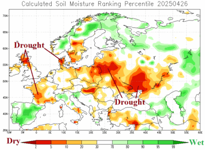
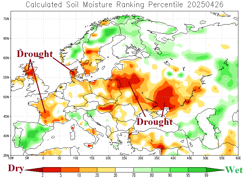
Checking drought concern areas heading into May 2025 reveals dry-to-drought conditions across the Southwest U.S., parts of the Central U.S. plus the Mid-Atlantic States to Florida. Drought across Europe to Southwest Russia is expanding. Ongoing drought in Brazil continues while Northern Argentina drought has strengthened. Southeast China drought remains intense.
04/25/2025, 8:29 am EDT

The Long-term Lack of Precipitation is in the Southwest and Coastal Mid-Atlantic States

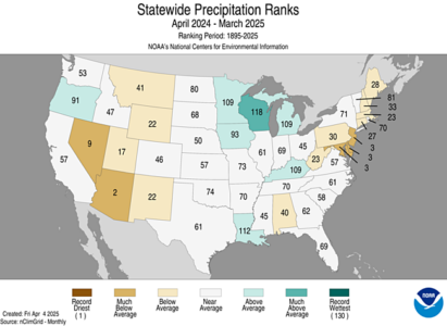
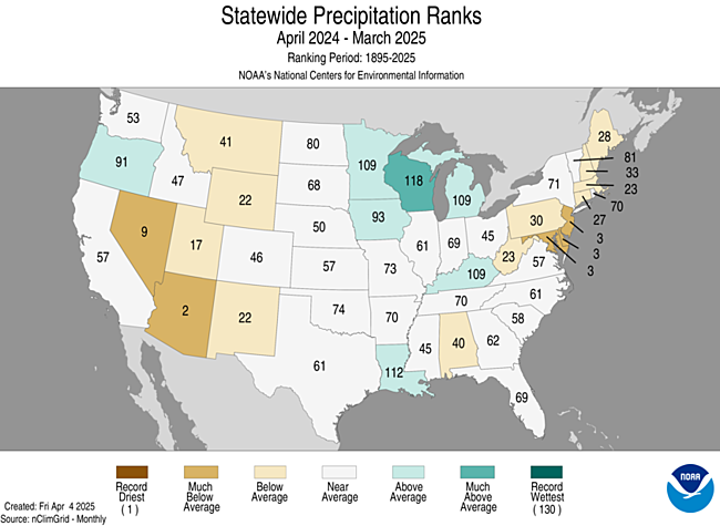
The 12-month U.S. precipitation trend is useful to determine what parts of the U.S. have the worst drought condition and potential for additional rapid decline in soil moisture given presence of a dry and warm climate as summer arrives. Clearly, the worst conditions are in Nevada/Arizona and Maryland/Delaware/New Jersey.
04/24/2025, 5:59 am EDT

Identifying Drought and Hurricane Risk in the U.S. for Later Summer

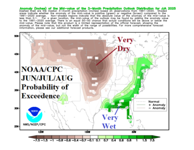
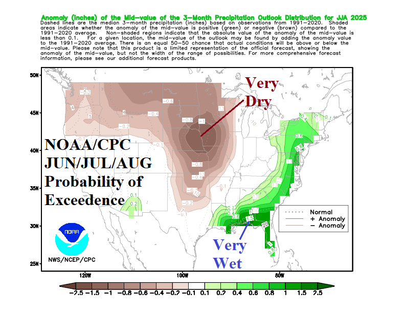
Alignment between NOAA/CPC probability forecasts and the constructed analog prepared by Climate Impact Company is in close agreement for precipitation patterns for meteorological summer 2025 into September 2025. Forecast confidence is above average on two high impact climate regimes which is a significant drought centered on Iowa (and vicinity) and land-falling tropical cyclone risk in the northeast Gulf of Mexico region. The evolution of each risk peaks in August and September.
04/23/2025, 8:32 am EDT

Latest on Solar Cycle 25 Which May Have Ended

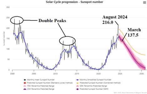
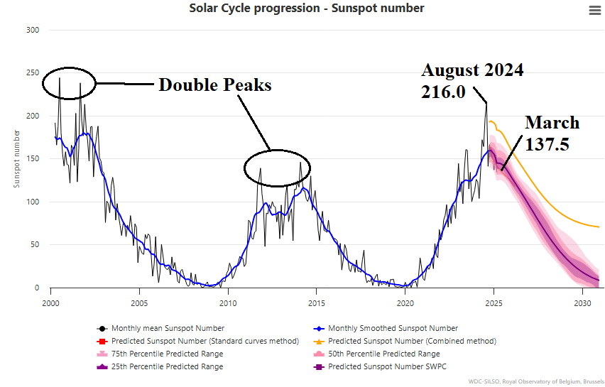
The solar maxima for cycle 25 has (apparently) passed although double (maxima) spikes during the last 2 solar maxima suggest another spike in solar activity is possible before a new solar cycle (26) initiates.
04/23/2025, 5:23 am EDT

Cold Risk Introduced to Australia Winter Outlooks

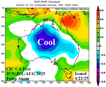
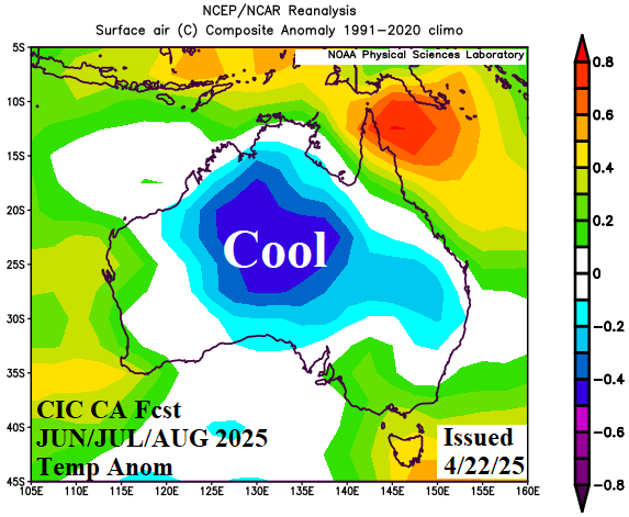
The Climate Impact Company constructed analog climate forecast shifted much cooler for meteorological winter 2025 across Australia. The catalyst to the outlook is an evolving negative phase of the Indian Ocean dipole while neutral ENSO continues. The upper air features a persistent upper ridge across the warming waters west of Australia with a compensating semi-permanent chilly trough over Australia.
04/22/2025, 6:01 am EDT

North Atlantic SSTA Much Cooler Than 1 Year Ago

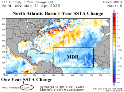
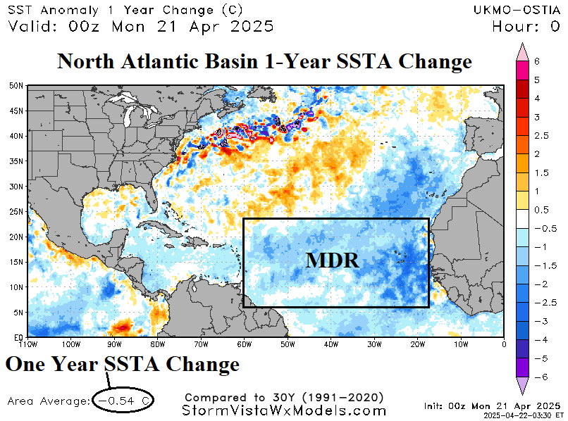
The current SSTA pattern across the North Atlantic basin is somewhat cooler than one year ago. The current North Atlantic basin SSTA is +0.25C which is close to +1 St Dev compared to +0.79C one year ago which is >+3 St Dev. The main development region (MDR) is the center of the cooler SSTA change and right now, is almost exactly at normal for late April. The Caribbean Sea marine heatwave has weakened.
04/21/2025, 9:19 am EDT

Madden Julian Oscillation Reactivates

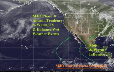
During Q4/2024 and Q1/2025 the Madden Julian oscillation (MJO) was active. Another weak-to-moderate wave of the convection phase of MJO is forecast into the eastern equatorial Pacific Ocean over the next 2 weeks.
04/20/2025, 7:05 am EDT

Another Cool Wave Toward Ukraine/Black Sea Region Next Weekend

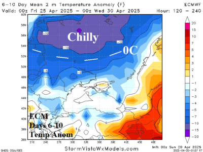
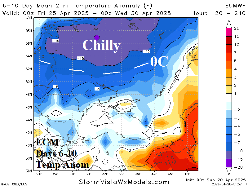
Through the next 5 days, the Black Sea region including Ukraine is exceptionally warm although flipping much cooler as a cold front arrives during the 6-10-day period when the 32F<0C line shifts south almost reaching Ukraine and Southwest Russia crop areas.