Another Cool Wave Toward Ukraine/Black Sea Region Next Weekend
04/20/2025, 7:05 am EDT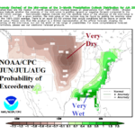
Identifying Drought and Hurricane Risk in the U.S. for Later Summer
04/24/2025, 5:59 am EDT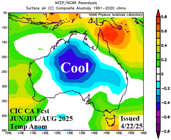
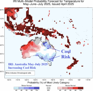
Fig. 1-2: The CIC-CA temperature anomaly forecast for meteorological winter across Australia and the IRI temperature probability forecast for MAY/JUN/JUL 2025 each indicate increasing cold risk.
Discussion: Yesterday’s Climate Impact Company constructed analog climate forecast shifted much cooler for meteorological winter across Australia (Fig. 1). The core of the cool weather risk is not in crop areas. The probabilistic temperature forecast from the International Research Institute for Climate and Society at Columbia University has shifted cooler across South and East Australia for the next 3 months including Southeast Australia crop areas (Fig. 2). Potential cold scenarios for mid-winter (July) include 2012 and 2022 (Fig. 3-4).
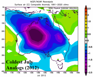
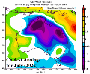
Fig. 3-4: The coldest analog years for July used to generate the Australia winter outlook.
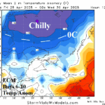
Across Europe and into Western Russia during the past week, a tale of two rainfall regimes has developed. Central and parts of West Europe have turned rainy while the core of the Southwest Russia/Southeast Europe drought area remains dry (Fig. 5). The operational ECM indicates a wet weather shift eastward partially affecting the Black Sea region in the latest 1-7-day forecast (Fig. 6). Many areas miss the rainfall. In the 8-14-day period, ECM is preferred over GFS due to better skill scores, especially in the 11-15-day period, favoring a regenerating dry scenario with remnant rains mostly over the Black Sea (Fig. 7). In the medium range, chilly weather featuring <32F/0C risk affects the Russia spring wheat zone.
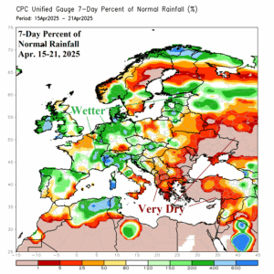
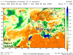
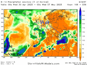
Fig. 5-7: The percent of normal rainfall during the past 7 days across Europe and the 14-day percent of normal rainfall forecast for Europe/Western Russia.
Recently, wet weather has spread across Southwest to East Brazil while Northern Argentina is very dry, and Central Argentina is very wet (Fig. 8). The GFS 15-day rainfall anomaly forecast indicates the wet weather trend continues and intensifies in Brazil while Northeast Argentina/Southeast Brazil remain very dry (Fig. 9).
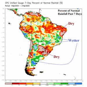
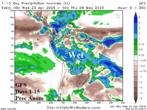
Fig. 8-9: The percent of normal rainfall during the past 7 days across South America and the 15-day precipitation anomaly forecast.