10/30/2024, 5:23 am EDT

Lowering Mississippi River to Receive Beneficial Rains

The subtropical jet is energized by the transient MJO and scoops low latitude moisture into the Central U.S. piling to 7+ in. in Southeast Kansas over the next 7 days. The rain should help raise the Mississippi River where low water has returned for a 3rd consecutive year.
10/29/2024, 5:49 am EDT

Lack of Snow Cover Northwest Eurasia About to Change

In Eurasia, snow cover is ahead of schedule in Northeast Asia although lagging in Northwest Eurasia. A colder upper trough bringing snowfall to Northeast Eurasia is projected for next week.
10/29/2024, 5:42 am EDT

Does a Dry/Hot Bias Develop in Eastern Australia Due to IOD/ENSO?

Both Australia Bureau of Meteorology and Climate Impact Company project a short-lived -IOD regime weakening by late 2024. The weekly Nino34 SSTA is -0.5C and the most recent multivariate ENSO index is -0.7, each indicating borderline weak La Nina. During the past 30 years when -IOD and weak La Nina was present, the NOV/DEC precipitation pattern across Australia favored drier than normal climate for eastern sections.
10/28/2024, 5:54 am EDT

Madden Julian Oscillation Rolling Eastward Again; Affects Weather Patterns

The strongest transient convection phase of the Madden Julian oscillation (MJO) since January 2024 is forecast to shift east of the Dateline to close October. Short-term effects of MJO are in the tropics including intensifying Tropical Cyclone Kong-Rey forecast to become a category-4 major typhoon heading for Taiwan.
10/27/2024, 7:06 am EDT

Much Cooler Europe early November Thanks to Negative Scandinavia Index Regime

In Europe, an evolving sharp negative phase of the Scandinavia index in early November indicates an amplified upper ridge over Northwest Eurasia and a compensating trough into Southeast Europe. The upper trough brings stormy and much cooler weather to Europe to Southwest Russia in the medium range.
10/27/2024, 6:56 am EDT

Brazil (and Argentina) Rains Continue

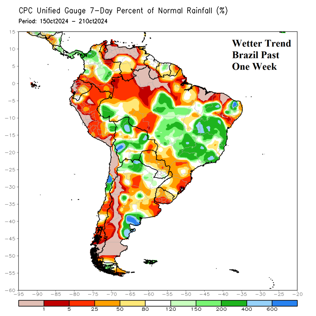
During October, Northwest Argentina turned very wet. During the past week, the wet pattern in Argentina shifted slightly southward and remains intense. Meanwhile, a separate wet weather pattern has emerged during the past week in Brazil featuring drought suppressing heavy rains from East-central Brazil eastward to the coast.
10/26/2024, 10:19 am EDT

Early November Tropical Cyclone Risk Update

After a series of GFS model runs indicating an East U.S. Coast tropical cyclone risk in early November, possibly disrupting voting day, forecast models are now in agreement the tropical system is likely to stay away from U.S. Atlantic Seaboard. The new forecast creates another problem, a heavy rainfall episode in early November centered on Texas and the southern Great Plains.
10/25/2024, 11:42 am EDT

Australia Heatwave Ahead!

A major heat wave is emerging in the medium range across Australia. A high-pressure ridge amplifies across Western Australia into early next week causing the onset of the hot weather pattern. East-coastal Australia is cool into early next week. However, the upper ridge is progressive, and the heat wave advances across Australia in the 6-10-day period according to the latest AI model, EXCARTA.
10/24/2024, 8:29 am EDT

Brazil Wet Pattern Lasts Through First Third of November

A wet pattern has developed over the past week across the Brazil drought region. The outlooks maintain the wet pattern featuring some excessive rains in the 10-day outlook. The ECMWF "weeklies" maintain the wet pattern through the first third of November. Significant easing the drought conditions is likely!
10/22/2024, 9:08 am EDT

Early November Tropical Cyclone Trouble Brewing

An ALERT for tropical cyclone development in the Caribbean Sea remains valid for next week. The last two GFS model runs develop a Northern Caribbean Sea hurricane which travels toward Florida and possibly the U.S. East Coast in early November.
10/21/2024, 2:13 pm EDT

Neutral ENSO, No Sign of La Nina

The Nino SSTA regions are locked-in on neutral phase. There is no shift in trend to indicate La Nina onset. In the subsurface, the anomalous cool water to fuel La Nina is diminishing. Most of the cool water is between 100 and 150 meters with about half the strength of several weeks ago.