07/31/2023, 1:47 pm EDT

El Nino Strengthening, Northern Oceans Are Very Warm!

The Nino34 SSTA warmed to +1.2C last week as oceanic El Nino strengthens to moderate intensity. The ENSO climate budged toward El Nino in July as supported by a 2-to-3-week period of a negative southern oscillation index (-SOI) although SOI has shifted into weak positive phase the past 2 days.
07/31/2023, 7:57 am EDT

Solar Maxima, El Nino Climate, and Record Warm Ocean for Winter 2023-24 Ahead

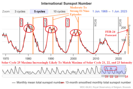
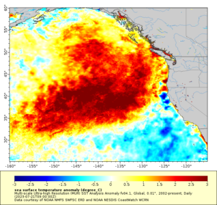
Yet another surprise, likely unknown is ahead for the winter 2023-24 northern hemisphere winter. For the first time in recorded history, the combination of an over-achieving solar maxima, El Nino climate, and much warmer than normal ocean surface is likely to drive the winter 2023-24 northern hemisphere climate pattern.
07/30/2023, 12:51 pm EDT

Cool Northern U.S. Pattern Change But Will It Last?

In 10-15 days, possible changes are looming. The global atmospheric angular momentum (GLAAM) pattern may flip negative for the first time during the summer season signaling a slowdown in the upper air pattern. If so, recent much warmer GFS 11-15-day forecasts and the ECM 16-20/16-30-day forecasts may regenerate another fierce hot upper ridge pattern for mid-to-late August.
07/30/2023, 12:43 pm EDT

Monitoring 2 systems in the North Atlantic While El Nino Climate is Developing

It’s still early, the most active part of tropical cyclone season is a few days away (Aug. 1st), but today’s analysis is reminiscent of past El Nino years in the modern climate (since the mid-to-late 1990’s) when tropical activity was biased to the East Coast or outer Atlantic especially during stronger El Nino.
07/25/2023, 5:32 am EDT

Heavy Rains Heading for Europe

Pattern change brings copious rainfall to Europe over the next 15 days with 3-5 in. indicated by ECM ENS across the South-central Mountains and parts of Eastern Europe. Of course, the wet weather is accompanied by cooler than normal temperatures. Southeast Europe misses the rain and cooler regime.
07/25/2023, 5:30 am EDT

Midwest U.S. Drought Worsening Again

Yesterday’s rainfall needed to neutralize dry Palmer Drought Severity Index (PDSI) analysis from NOAA/CPC revealed the Midwest U.S. Drought worsened last week. Short-term forecasts indicate searing heat risk increase and limited rainfall ahead into next week as the drought will continue to worsen.
07/24/2023, 11:50 am EDT

Atmospheric El Nino Climate Continues to Lag Oceanic El Nino

Oceanic El Nino continues to slowly strengthen and is now at moderate intensity. Subsurface warming is convening in the eastern equatorial Pacific to provide more ammunition to strengthen El Nino. However, the sustained 1-2-month-long negative southern oscillation index required to generate an El Nino climate has not yet materialized.
07/24/2023, 9:44 am EDT

GFS Occasionally Indicating East Coast Hurricane In 11-15 Days

On occasion, the GFS and ECM develop a tropical wave within the outer North Atlantic active ITCZ and carry that event west-northwest with development possible by late this week. GFS has produced two model runs that develop this system into a hurricane reaching the Mid-Atlantic Coast in 13 days.
07/23/2023, 3:49 pm EDT

Dry Soil Moisture Emerging In Australia

In Australia, the soil moisture conditions are turning drier on the East Coast and much of Western Australia. The latest 15-day outlooks indicate a changeable thermal pattern through 10 days but averaging mostly warmer than normal in the extended-range.
07/23/2023, 3:45 pm EDT

Monitoring The 30-31C/86-87F SST Presence In The North Atlantic Basin

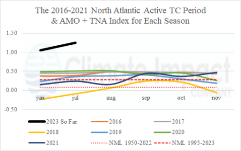
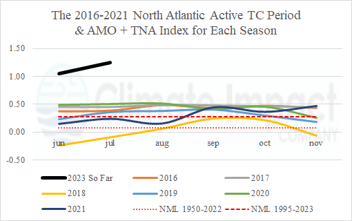
For the first time in the historical record, accumulated cyclone energy (ACE) index was above normal for a 6-year period (2016-21) averaging 159 which is considerably higher than normal (126). One of the primary contributors to the active period is the much warmer than normal North Atlantic basin sea surface temperature (SST) pattern featuring increased frequency of unusually warm SST of 30-31C (or warmer) which ignites major hurricanes.
07/19/2023, 4:59 am EDT

U.S. Heatwave to Expand to Midwest and Mid-Atlantic U.S. and Midwest Drought to Re-intensify

The historic California, Southwest U.S., and Texas heatwave of mid-July will expand across the U.S. to close the month. The risk of >100F shifts across much of the Great Plains to the Mid-south States in the 6-10-day period. In the 11-15-day period, the risk of >100F shifts eastward through the southern Ohio Valley, Tennessee Valley, and into the Mid-Atlantic States.