Midwest U.S. Drought Worsening Again
07/25/2023, 5:30 am EDTEl Nino Strengthening, Northern Oceans Are Very Warm!
07/31/2023, 1:47 pm EDT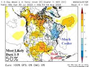
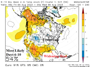
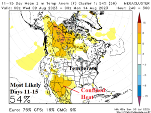
Fig. 1-3: The mega-cluster ensemble “most likely” temperature anomaly forecast for North America through 15 days.
Discussion: An almost early autumn feel to the Northeast U.S. this morning as yesterday’s strong cold front (658 wind damage reports) pushes the mid-summer heat southward. Heat Advisories remain in effect for the entire Gulf region with Excessive Heat Warnings in effect as far north as Southeast Kansas. The Northeast cool expands westward and southward this week while the extreme heat persists in Texas and vicinity (Fig. 1).
The “most likely” U.S. temperature anomaly pattern in the 6-10-day period is widening South U.S. heat while north of the hot zone, the U.S. is temperate (Fig. 2). In the 11-15-day period, heat is stuck across the New Mexico/Texas drought area (Fig. 3).
On the rainfall forecast, some monsoon moisture works its way into the Northwest U.S. to central/northern Rockies causing persistent thunderstorms while parts of the Midwest Drought area also gain some beneficial rainfall (Fig. 4-6). The Northeast/Mid-Atlantic region looks thundery in the 6-10-day period.
In 10-15 days, possible changes are looming. The global atmospheric angular momentum (GLAAM) pattern may flip negative for the first time during the summer season signaling a slowdown in the upper air pattern. If so, recent much warmer GFS 11-15-day forecasts and the ECM 16-20/16-30-day forecasts (Fig. 8-9) may regenerate another fierce hot upper ridge pattern for mid-to-late August.
Bottom line? Cooler Northern U.S. pattern change ahead while heat retreats to the Southern U.S. But! Summer is not over. Big heat could return for the second half of August most prominently in the East U.S.
The U.S. population weight CDD forecasts identify the hotter influence of the renegade GFS (Fig. 10). The GFS may be too quick to reverse the pattern hotter again, but a dramatic warm-up after 15 days is likely.
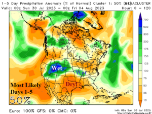
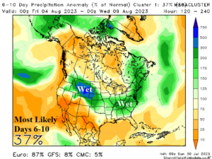
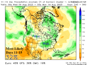
Fig. 4-6: The mega-cluster ensemble “most likely” precipitation anomaly forecast for North America through 15 days.
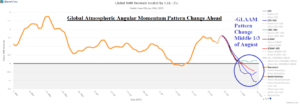
Fig. 7: The global atmospheric angular momentum 90-day observations and 15-day forecast indicate a pattern change.
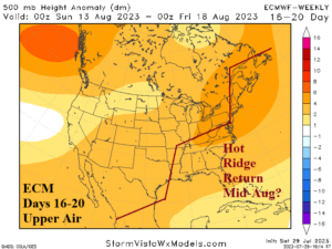
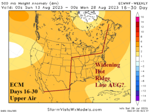
Fig. 8-9: ECM 16-20-day and 16-30-day upper air forecast for the U.S.
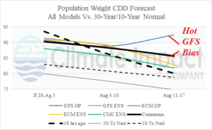
Fig. 10: U.S. population weight CDD forecast utilizing all models, their consensus, and comparing with 48 hours ago and the 30-year/10-year normal.