Cool Northern U.S. Pattern Change But Will It Last?
07/30/2023, 12:51 pm EDTThe El Nino Ridge Warms Mid-winter in South America.
08/01/2023, 10:34 am EDTHighlight: El Nino strengthening, northern oceans are very warm! The 2023 El Nino is potentially quite strong based on the subsurface upper ocean heat.
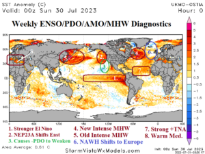
Fig. 1: Daily global SSTA analysis.
Discussion: The Nino34 SSTA warmed to +1.2C last week as oceanic El Nino strengthens to moderate intensity (Fig. 1). The ENSO climate budged toward El Nino in July as supported by a 2-to-3-week period of a negative southern oscillation index (-SOI) although SOI has shifted into weak positive phase the past 2 days. For a full-tilt El Nino climate to generate, a lengthier period of -SOI is required. An El Nino climate should emerge by September. Elsewhere, marine heat waves (MHW) dominate the mid-latitude northern hemisphere oceans including NEP23A which has shifted east and reached the Northwest U.S. Coast and caused the long-standing cool phase of the Pacific decadal oscillation (-PDO) to begin weakening. Strong MHW’s are strengthening off Newfoundland and either side of Japan. In August, an amplified high pressure resides northeast of the Japan MHW while previous high pressure across the Newfoundland MHW has weakened. The North Atlantic warm hole (NAWH) has re-emerged off the West Coast of Europe causing the current unusually cool and wet trough dominating their local climate. In the main development region (MDR) for hurricanes in the North Atlantic basin the tropical North Atlantic index remains robustly (record) warm and offers support for strong storms this season in the face of an El Nino climate that usually suppresses activity. Finally, the Mediterranean Sea has warmed significantly and certainly contributed to high pressure causing the fires in Southeast Europe.
Currently, in the equatorial subsurface, the East Pacific has warmed dramatically in support of El Nino development with a peak warm anomaly of +6.091C (Fig. 2). By contrast, the two strongest El Nino’s with data available to compare July subsurface temperature anomalies with 2023 occurred in 2015 and 1997. In July 2015, the peak warmth in the equatorial East Pacific subsurface was +5.241C therefore not quite as strong as this year (Fig. 3). Keep in mind, the 2015 El Nino tied the 1997-98 and 1982-83 El Nino’s as the strongest on record. In July 1997, the equatorial East Pacific subsurface peak warm anomaly was a whopping +7.552C (Fig. 4).
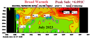
Fig. 2: Equatorial Pacific subsurface temperature anomalies identify broad warmth with peak warm anomaly (+6.091C) in the East Pacific fueling El Nino.
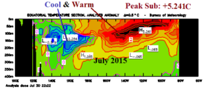
Fig. 3: Equatorial Pacific subsurface temperature anomalies for the last developing strong El Nino in July 2015 identify both cool and warm subsurface anomalies with an East Pacific warm peak of +5.241C.
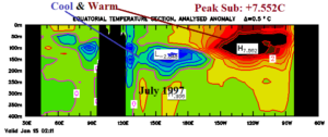
Fig. 4: Equatorial Pacific subsurface temperature anomalies for the historic 1997 El Nino from that July which identify a cool/warm split between either side of the Pacific and a +7.552C warm peak in the East Pacific subsurface.