El Nino Strengthening, Northern Oceans Are Very Warm!
07/31/2023, 1:47 pm EDTSummer 2023 CDD’s are not impressive (mixed demand from region-to-region across U.S.)
08/03/2023, 7:25 pm EDT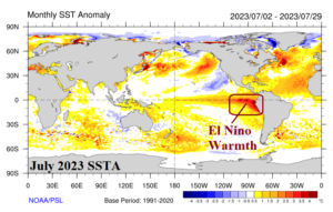
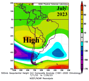
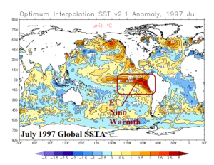
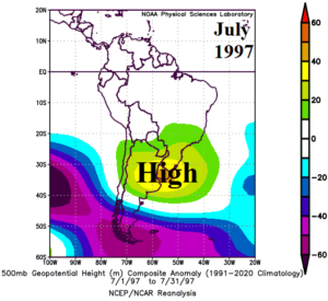
Fig. 1-4: The 500 MB anomalies for July 2023 and 1997 (left) and corresponding warming of the northeastern South Pacific related to vigorous El Nino.
Discussion: A warm mid-winter pattern across South America this year thanks to an amplified upper-level ridge centered just-off the North Coast of Chile (Fig. 1) and inspired by aggressive anomalous warmth of the northeast South Pacific Ocean off the South America Coast and vigorous El Nino warming of the eastern tropical Pacific (Fig. 2). The July 1997 El Nino pattern and correlation to an upper-level ridge (Fig. 3-4) during mid-winter is not quite as robust although similar thematically.
The warmer than normal ocean water also produces above normal low atmospheric moisture which, if the right pattern comes along, is entrained into low-pressure systems to produce above normal rainfall. A wetter pattern change is likely by SEP/OCT 2023 across Brazil (Fig. 5-6).
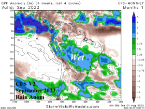
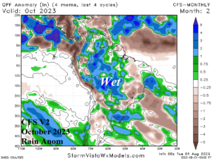
Fig. 5-6: NCEP CFS V2 September and October 2023 rainfall anomaly forecast for South America.