
Incoming Heat Surge for High Demand PJM Sector
06/17/2025, 3:31 pm EDT
U.S. Summer CDD’s Climbing, Forecast Close to 2022 and 2024 Heat
06/23/2025, 8:22 am EDT
Climate Impact Company U.S. Medium Range Report
Issued: Thursday June 19, 2025
Highlight: Dangerously hot next week PJM Sector.
New long-lead NOAA climate forecasts this morning plus the seasonal drought outlook.
Charts of the day: NOAA/NWS weather watch and warnings plus the hottest of the next 7 days in the East.
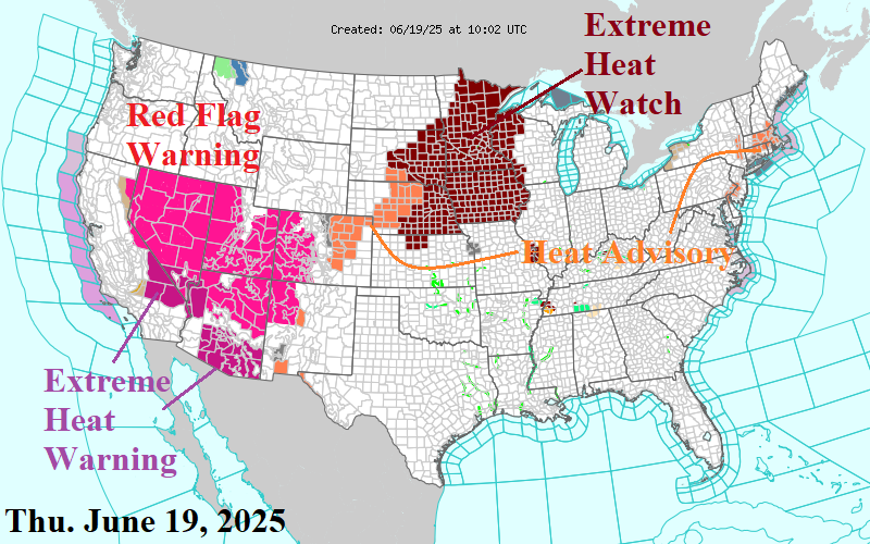
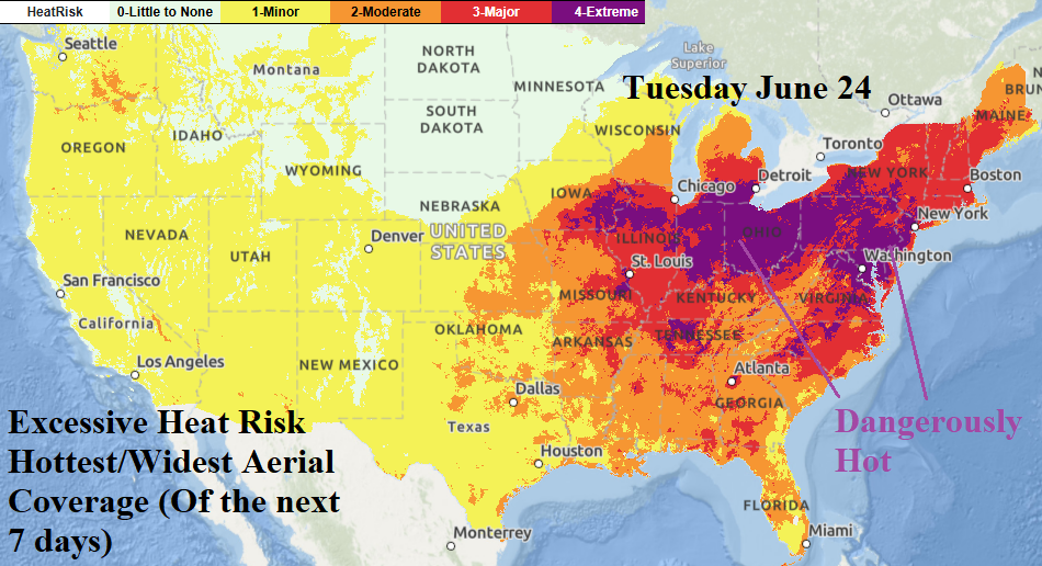
Discussion: NOAA/NWS weather watch, warning, and advisory map for this morning reveals an Extreme Heat Watch over the Upper Midwest. The watch becomes a warning later today. The extreme heat warnings shift eastward to the Northeast Corridor by early next week. A Red Flag Warning for widespread fire risk covers the Great Basin. Expect this problem to spread northward. An Excessive Heat Warning is issued for the Southwest U.S. Deserts. The hottest day in the 7-day NOAA/NWS excessive heat forecast is next Tuesday when the Ohio Valley, including the Chicago area, eastward through the Mid-Atlantic encounters widespread dangerously hot conditions.
Medium-range 6-10 Day Forecast Valid June 24-28, 2025 (24-Hr Change right)
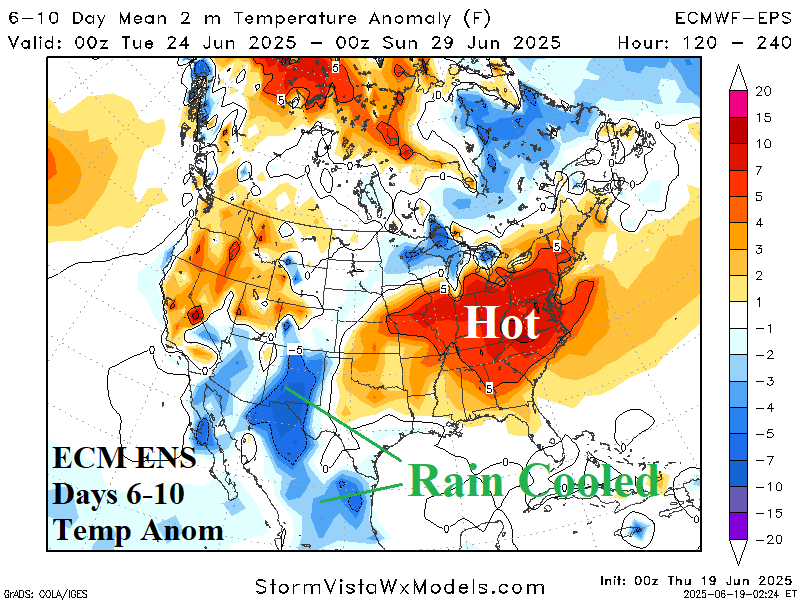

Discussion: “Ring of fire” thunderstorms arc from New Mexico to the Great Lakes and the latent heat release of the convection amplifies the hot upper ridge pattern in the East. Excessive heat stress caused by the combination of hot temperature and high dew points anchors across the Ohio Valley and Mid-Atlantic States.
Medium-range 11-15 Day Forecast Valid June 29-July 3, 2025 (AIFS right)


Discussion: ECM ENS emphasizes a rebuilding hot upper ridge over the Northwest U.S. while Ohio Valley/Mid-Atlantic heat lingers although less intense. The 24-hour change is much warmer in the Northwest.
U.S. Medium-range Precipitation Forecast


Discussion: Monsoon moisture will cause the New Mexico to Michigan arc of thunderstorms to unload significant amount of rain in the 6-10-day period. Note that away from the wet arc, the remainder of the U.S. and Canada are dry. In the 11-15-day period, monsoon moisture soaks Mexico and Texas while powerful thunderstorms suppress Mid-Atlantic heat. The Canadian Prairies turn drier during the period.
Days 16-20 Extended range Temperature Forecast valid July 4-8, 2025


Discussion: Low confidence forecast favors anomalous heat possibly rebuilding in the East and (also) the Mid-south States.