12/31/2025, 9:58 am EST

The Warming Oceans Increasingly Contributing to High Impact Weather/Climate in 2025

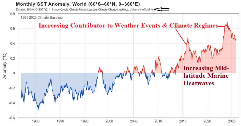
Globally, 2025 projects as the third warmest on record (DEC-25 data not yet available as of this writing). As of December 1st, the U.S. has observed the fifth warmest year in the 131-year period of record. A significant contributor to the warmer climate is the influence of increasing ocean temperature, most notable in the middle latitudes accelerated by the presence of marine heatwaves (MHW).
12/31/2025, 8:29 am EST

Busy Period Ahead: Wides Swings in U.S. HDD Forecasts!

Next week is trending warmer except GFS ENS which maintains a colder pattern. Forecast models are disagreeable for January 9-15 although majority of solutions are trending colder. The week-4 forecast is prohibitively cold according to CFS/ECM and AI. CFS/ECM trend toward a thaw by early February.
12/31/2025, 8:25 am EST

Explaining the Extremely Wet Northern Australia DEC-25 Climate

Prohibitive rainfall was observed across Northern Australia during December 2025 including departures from normal >400 MM (~16 in.) in northwest Queensland. Conversely, despite La Nina climate, the East Coast was extremely dry. The heavy convection driving the wet climate across Northern Australia caused previously warm SSTA to cool significantly, especially off the East Coast where 30-day changes exceed 4C.
12/30/2025, 6:02 am EST

Arc of Heavy Rain in South America, Northern Australia Excessive Rainfall, and Losing the Western Canada Cold Air Source Region

Never a shortage of dramatic weather events as 2025 comes to a close. A lingering negative phase of the Antarctic oscillation (-AAO) causes a mid-latitude trough east of Argentina that extends northwestward to soak Brazil into the New Year. Meanwhile, excessive rainfall across Northern Australia will continue. The arctic air source region across Western Canada during December is likely to dissipate in early January due to a cold stratosphere.
12/29/2025, 11:54 am EST

Equatorial Pacific Ocean Subsurface Heat Warming; La Nina Likely to End Early 2026

Last week, the Nino SSTA regions warmed too near, or warmer than the La Nina threshold. Implied is the short duration late 2025 La Nina episode is past peak intensity. Upper ocean heat is steadily diminishing in the equatorial East Pacific, a definite sign that La Nina is losing cool fuel to sustain intensity into the New Year.
12/28/2025, 1:45 pm EST

Plethora of U.S. Weather Hazards Today

Short-term hazards are intense and feature Blizzard Warnings across the Upper Midwest to the Northern Great Lakes and widespread high wind alerts for the East-central and Midwest U.S. Winter Weather Advisories for snow to ice extend across the Northeast States.
12/26/2025, 8:19 am EST

U.S. and Europe HDD Forecast Update

After a frigid start to December, the month finishes very warm. Consequently, cold U.S. population weight HDD projections for DEC-25 from earlier this month are revised sharply warmer. The JAN/FEB-26 forecast remains close to the 10-year normal. In Europe, colder weather arriving in late December takes the edge off the previously mild pattern for early meteorological winter while the incoming cold is sufficiently lengthy in duration to cause a colder mid-winter revision.
12/26/2025, 8:16 am EST

Atmospheric River Closes After Today; Northern Mid-Atlantic Snowstorm Today

Many weather hazards continue this holiday weekend. Ongoing flooding is widespread in California as the “atmospheric river” storm track begins to wind down. Heavy mountain snow continues for Northern California and Sierra Nevada Mountain Ranges. Snow advisories extend inland to the Rocky Mountains. Dense fog in the Midwest and Northern Gulf States, typical of unseasonably mild air. An ice storm rages in Western Pennsylvania and Winter Storm Warning for the northern Mid-Atlantic region today for heavy snow.
12/26/2025, 8:13 am EST

Northern Hemisphere Climate Drivers Early January

Climate drivers in the 11-15-day extended-range forecast indicate the Madden Julian oscillation (MJO) is weak therefore tropical forcing is weak. The stratosphere is shifting much colder following the NOV/DEC warm event as indicated by the 40-day CFS V2 projection. The core of the colder stratosphere is in the same location as the NOV/DEC warming event, across northwestern North America.