12/16/2025, 5:46 am EST

Multi-variate ENSO Index Returns! Identifies Well Established La Nina Climate!

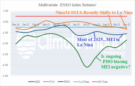
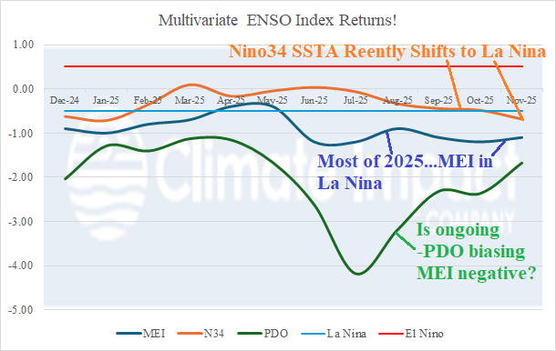
An important climate diagnostic, missing since last April, has returned this month: Multivariate ENSO index (MEI). The MEI identifies the response of the atmosphere (30S to 30N) to the Pacific equatorial sea surface temperature anomaly (SSTA) regime. Note that the conventional climate diagnostic to identify ENSO phase, the Nino34 SSTA, only recently shifted to La Nina. A La Nina regime is indicated by MEI all but APR and MAY of the past 12 months.
12/16/2025, 4:43 am EST

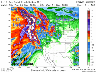
Historical Precipitation Event Ahead West U.S. – Causes and Implications

The 2025-26 cold season is barely underway and already two dramatic weather regimes are identified: 1.) The just-ending arctic outbreak across the East U.S. and 2.) The evolving excessive precipitation event for the West Coast lasting the remainder of December and into January.
12/15/2025, 4:07 pm EST

At The Surface, La Nina Strengthened Last Week. However, Subsurface Cool Fuel Diminishing.

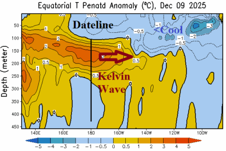
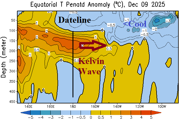
During the past week, the Nino34 and Nino3 sea surface temperature anomaly (SSTA) regions across the east-central and east equatorial Pacific Ocean cooled to the second strongest level of the weak late 2026 La Nina episode. The central equatorial Pacific and off the northwest coast of South America are near normal. Of interest is the appearance of a Kelvin Wave shifting east of the Dateline during early December.
12/14/2025, 10:06 am EST

MJO is Now Quiet, Stratosphere Colder, Therefore, a Milder U.S. Pattern Ahead. But! There are Caveats!

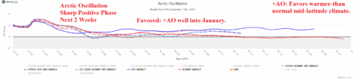
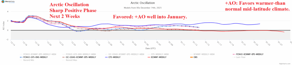
The arctic oscillation (AO) which identifies the location of the polar vortex indicates a change to positive phase the next 1-2 weeks as the recent frigid Canadian polar vortex shifts poleward. The shift toward the North Pole allows milder Pacific maritime influence to warm the U.S. pattern. The extended-range AO forecast suggests the positive phase may continue well into January. However, there are caveats.
12/12/2025, 9:53 am EST

Cold Retreat to Canada; New York/New England at Risk of Returning Cold Late December

The intense Pacific “atmospheric river” storm track across California to the Great Basin is releasing mild maritime air eastward of the Continental Divide extending anomalous warmth to the Atlantic Seaboard. Canada is very cold, and the attendant chill should extend southward across snow cover. New York and New England are at risk of "sneaky cold" late December.
12/12/2025, 9:49 am EST

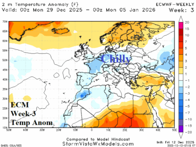
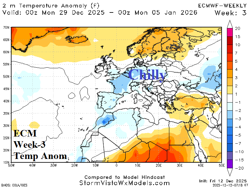
Turning Colder into Early January Europe

Upper trough maintains the Mediterranean Sea storm track in late December/early January. North of the storm track, colder east wind from Russia develops. However, dry pattern prevents any snow gain.
12/11/2025, 8:33 am EST

Next Arctic Air Mass Forms in Western Russia; Threat to Europe?

Lack of snow cover is helping to propel a mild climate across Europe. However, a colder change may be on the way in the extended range. Stratospheric warming propelling an arctic air mass in Canada and into the East U.S. during early December shifts westward to Asia during the next 2-3 weeks. The emerging stratospheric warming over Asia will cause a cold air mass to initiate across Northern Asia into early next week.
12/11/2025, 8:29 am EST

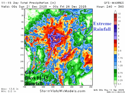
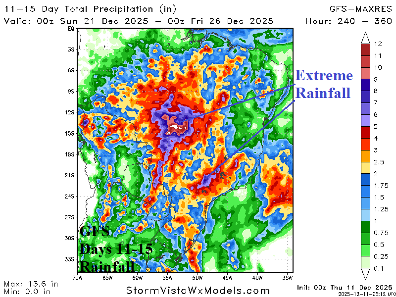
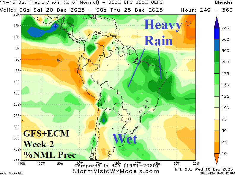
Brazil 15-Day Rainfall Outlook Trending Wetter

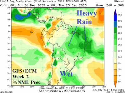
Wet weather continues to emerge and intensify across Brazil. The rainfall is making a difference in soil moisture as East Brazil loses their wet signature. Additional heavy to excessive rainfall is on the way!
12/10/2025, 11:56 am EST
A graph showing the different types of temperature AI-generated content may be incorrect.

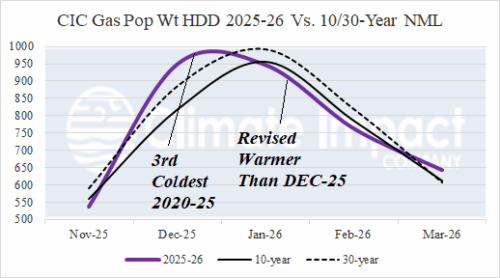
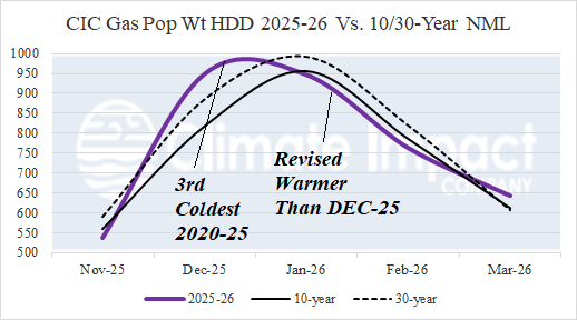
Adjusting Heating Demand Forecasts for Winter 2025-26 in U.S. and Europe

The DEC-25 U.S. gas population weight HDD is revised colder to 949, the coldest DEC since 2010 and 3rd coldest of this century. Previously, cold JAN-26 forecasts reversed warmer with mid-NOV updates and then colder with the early DEC projection. Operational models are shifting much warmer for JAN-26 therefore a warmer revision is necessary. The JAN-26 HDD forecast warms from 981 to 947 which ranks 13th coldest of 2020-25.
12/10/2025, 7:09 am EST
A map of the north AI-generated content may be incorrect.

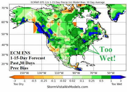
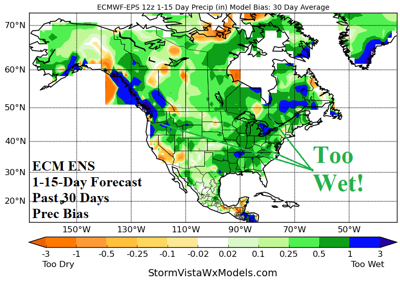
Is Lack of Equatorial Warm SSTA Contributing to Wet Bias of Operational/AI 15-day Forecasts?

The general lack of precipitation of the past month (except Indonesia) may be a contributor to a wet bias of operational and AI 15-day forecasts for North and South America plus Europe. The ECM ENS is characteristic of all operational forecast models producing a wet forecast bias in 15-day outlooks for the past 30 days for the Americas. AI models have a similar common problem as demonstrated by AIFS ENS for Europe.
12/10/2025, 3:38 am EST
A map of the weather AI-generated content may be incorrect.

MJO-Inspired Heavy Rain for Brazil, Once Effect Fades, Brazil Drier into New Year

The wet weather pattern has shifted to Brazil during early December. Heavy rain was observed across Northern Chile to northwestern Argentina during the past week. The 10-day outlook equally combining GFS and ECM reveals wet weather shifts to Paraguay and eastward. Recently developed dryness in Argentina continues.