MJO is Now Quiet, Stratosphere Colder, Therefore, a Milder U.S. Pattern Ahead. But! There are Caveats!
12/14/2025, 10:06 am EST
Warm Northeast Pacific Enhances “Atmospheric River”
12/19/2025, 8:36 am EST
Climate Impact Company Climate Research
Issued: Tuesday, December 16, 2025
Highlight: Historical precipitation event ahead for the West U.S., causes and potential mid-to-late meteorological winter implications.
Executive summary: The 2025-26 cold season is barely underway and already two dramatic weather regimes are identified: 1.) The just-ending arctic outbreak across the East U.S. and 2.) The evolving excessive precipitation event for the West Coast lasting the remainder of December and into January. Past similar regimes are not caused by any (particular) climate regime, making a climate forecast of these extreme events difficult. The catalyst to the December arctic outbreak was a stratospheric warming event confined to the American side of the North Pole. The long duration “atmospheric river” pattern is enhanced by cooling of the stratosphere extending from Eurasia to North America the last third of December. Past precedents for both California and the Northwest U.S. receiving excessive precipitation during DEC/JAN are limited t0 2005-06, 2007-08, and 2015-16. The standout analog is 2007-08 which shifted the stormy upper trough from the West Coast to the Interior West during January and eastward to the Central U.S. in February.


Fig. 1-2: The Northwest is rapidly turning wetter, including streamflow increase.


Fig. 3-4: Prohibitive precipitation amount is forecast by ECM through the next 15 days likely to continue in the 16-30-day period.
Discussion: A rapid increase in precipitation across Washington to Western Montana has shifted the percent of normal precipitation regime to >200% particularly across the Cascades (Fig. 1) with attendant streamflow increase to >98th percentile (Fig. 2). ECM 15-day precipitation amount projection includes >12 inches for the Cascades to the Sierra Nevada and coastal mountain ranges of the northern half of California (Fig. 3). The heavy precipitation reaches the Northern Rockies. The ECM 16-30-day percent of normal precipitation forecast maintains the stormy pattern (Fig. 4).
The changing polar stratosphere is a significant contribution to the projected long-lasting “atmospheric river” pattern across the U.S. West Coast. Stratospheric warming during later November and early December across Canada inspired a polar vortex (Fig. 5) delivering arctic air to the East U.S. The polar vortex lifts northward to Northern Canada this week (Fig. 6) and splits in the 6-10-day period with one center evolving off the North America West Coast (Fig. 7) to inspire the energetic storm track. The inspiration for the polar vortex splitting is a cooling stratosphere extending from Eurasia across the polar region and into North America (Fig. 8). Once the stormy trough off the North America West Coast forms, the feature becomes semi-permanent well into January.

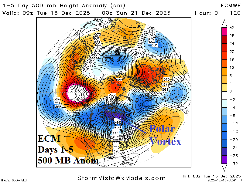
Fig. 5-6: The mid-November to mid-December 2025 polar vortex pattern bringing arctic air into the East U.S. shifts to Northern Canada this week.
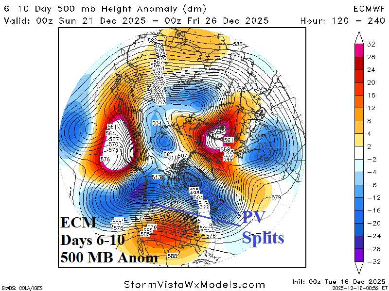

Fig. 7-8: The polar vortex splits in the 6-10-day period with one center relocating to the Northeast Pacific intensifying an “atmospheric river” storm track. The AR pattern continues into the extended range as the stratosphere cools over North America.
Implications are a historical precipitation event across the West U.S. extending through early calendar winter. Recent excessive precipitation patterns for DEC/JAN were across the Coastal Northwest during the 2023-24 El Nino and California with the 2022-23 La Nina. Both regions observing excessive precipitation during DEC/JAN occurred in 2015-16 (El Nino), 2007-08 (La Nina), and 2005-06 (La Nina). The Pacific decadal oscillation (PDO) was in the cool phase for 3 of the 5 listed events (except for 2005-6 and 2015-16). Stratospheric cooling extending from Eurasia cross-polar to North America was present for the 2015-16 and 2007-08 wet West Coast episodes. The catalysts to the excessive precipitation regimes are not obvious and consistent, which explains why this regime was not expected.
The best analog is DEC/JAN 2007-08 due to presence of a reasonably similar ENSO and stratospheric pattern for early calendar winter. Using the analog to project the after the stormy pattern fades in January, an upper trough drops anchor on the West to cause a cold regime (Fig. 9). The trough shifting from offshore to the Interior West is reasonable given the increase in snow cover from the DEC/JAN stormy pattern and the tendency for upper troughs to hover across the snow cover. The analog year shifts the cold trough to the Central U.S. in February (Fig. 10). Dynamic models keep the trough pattern in Canada for JAN/FEB. Dynamic models did not predict the expected long duration atmospheric river pattern.
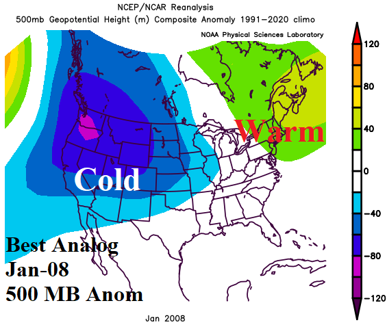
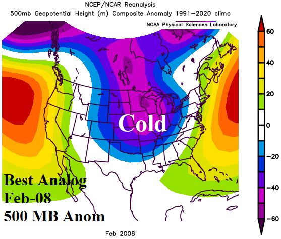
Fig. 9-10: The best analog year for 2025-26 expectations (based on the wet West Coast regime) is JAN/FEB 2008. The upper air pattern for each month is indicated.