The Springtime ENSO Prediction Barrier LINGERS!
05/14/2026, 4:58 am EDT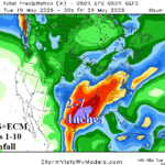
Tropical Forcing Increases (MJO); Supports Significant Rainfall/Flood Risk for Texas/Louisiana
05/19/2026, 8:49 am EDT
![]()
Climate Impact Company Sunday Global Weather/Climate Report
Issued: Sunday May 17, 2026
Highlight: ENSO update; U.S. rainfall forecasts.
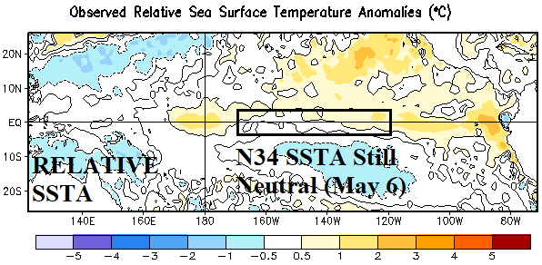
Fig. 1: NEW Relative global SSTA analysis for the week of April 30-May 6, 2026, reveals neutral ENSO.
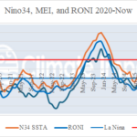
ENSO update: The NEW relative SSTA analysis across the Pacific basin reveals neutral ENSO as measured within the Nino34 SSTA region (Fig. 1). Conversely, the standard global SSTA analysis reveals moderate El Nino has formed (Fig. 2). As of late April, multivariate ENSO index was -0.6, indicating a lingering La Nina climate. In May, the southern oscillation index (SOI) has recently shifted to an aggressive negative phase (-2.8 today) with a strengthening negative 30-day average (-0.8) suggesting the La Nina climate has ended and El Nino climate approaching quickly The Madden Julian oscillation (MJO) is not particularly supportive of El Nino strengthening. There is not an obvious westerly wind burst (WWB) in the equatorial Pacific. Finally, the immense upper ocean heat in the East Pacific equatorial subsurface has eased intensity slightly during the past week. In conclusion, the ENSO MAR-MAY prediction barrier remains. Super El Nino forecasts by many dynamic models for later 2026 are not guaranteed.
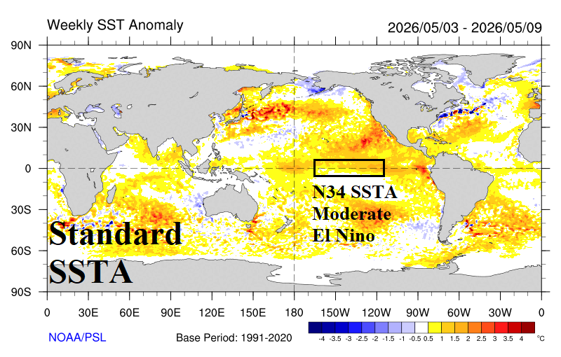
Fig. 2: Standard global SSTA analysis for the week of May 3-9, 2026, reveals moderate strength El Nino.
U.S. soil moisture: Last week’s U.S. Drought Monitor revealed a persistent extremely high percentage of aerial coverage in the U.S. where dry-to-drought soil conditions are present. The catalyst to the dry soil regime is made more intense by mostly La Nina climate during this decade. Dangerous historic dry soil regimes are spread across the entire Southeast and Mid-Atlantic States, parts of the Mid-south U.S., and parts of the western Great Plains westward to the Great Basin and Oregon’s Columbia Basin (Fig. 3). Interestingly, up until recently, the Midwest U.S. has observed accelerating dryness while the Gulf Coast (and Northern New England) have shifted much wetter (Fig. 4). Given recent observations and May trend, the Great Plains drought risk is increasing.
Although forecast models have been notoriously over-forecasting rainfall during this spring season, especially in drought areas, ECM ENS insists on a wet regime in their latest 15-day forecast for the Upper Midwest and particularly Texas (Fig. 5). In between the two wet zones marginally beneficial rains are in the forecast for the central Great Plains and Midwest States. The ECM ENS 15-day forecast edges wetter across the Midwest U.S. and East Texas (Fig. 6).
In the extended-range, ECM and Graph Cast vary with moderate or stronger wet signatures in the Great Plains. ECM has the wettest forecast (Fig. 7) but also the wettest forecast bias. Graph Cast is not as wet and (more) respectful of the long-term climate (Fig. 8). The generally wetter outlooks by all models for late May and into June are related to developing El Nino with MJO as a specific contributor. However, the ENSO/MJO (wet) contribution is not obvious (yet).
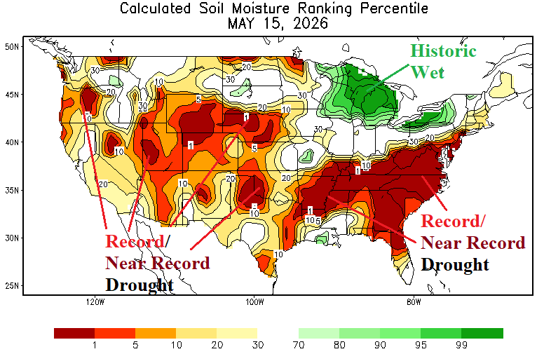
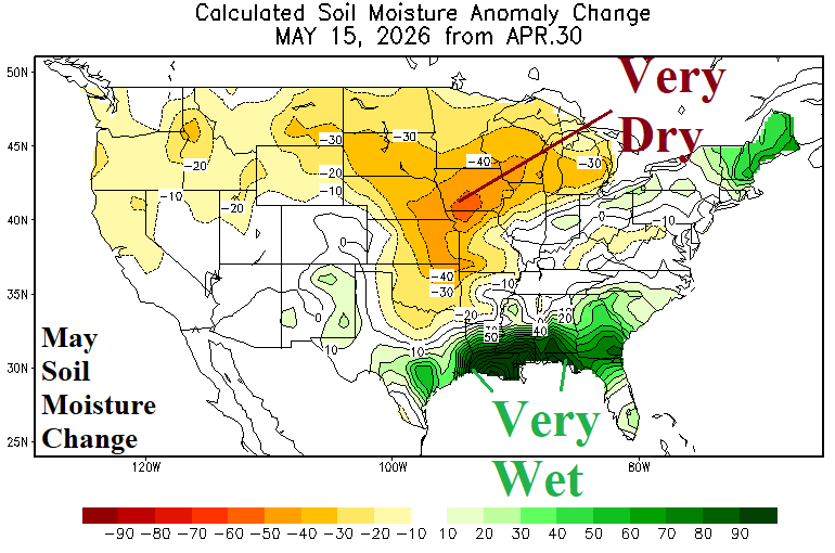
Fig. 3-4: Daily U.S. soil moisture rankings identify widespread significant drought while the May change (so far) reveals Midwest drying.

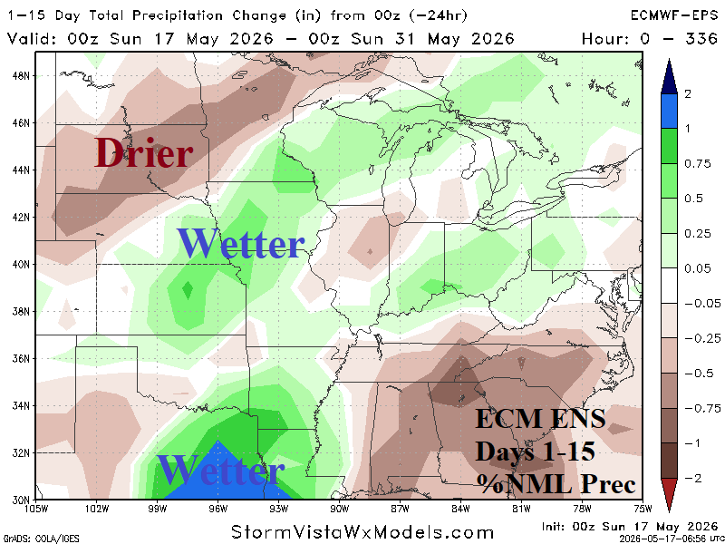
Fig. 5-6: Daily U.S. soil moisture rankings identify widespread significant drought while the May change (so far) reveals Midwest drying.
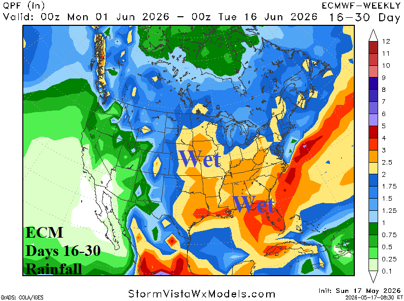

Fig. 7-8: ECM and Graph Cast 16-30-day rainfall forecasts across North America.