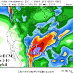
Tropical Forcing Increases (MJO); Supports Significant Rainfall/Flood Risk for Texas/Louisiana
05/19/2026, 8:49 am EDT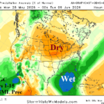
Latest 15-Day and 16-30-Day U.S. Precipitation Forecasts Indicate Rapidly Drying Soils North-central U.S. (and Vicinity)
05/25/2026, 10:02 am EDT![]()
Climate Impact Company 2026 East Pacific Basin
Tropical Cyclone Outlook
Issued: Friday May 22, 2026
Highlight: 13 hurricanes forecast in 2026! Above normal impacts to Mexico, Southwest U.S., Southern California, Western Gulf of Mexico, and Hawaii.
Executive summary: The 2026 East Pacific basin tropical cyclone season is forecast above too much above normal activity. A large mass of unusually warm surface and subsurface water is present off the Southwest Coast of North America and coupled with a developing vigorous El Nino should provide an environment exceptionally supportive of many dangerous storms. The anomalous warm water extends well to the north supporting potential longer northward travel and higher impacts once well inland (Fig. 1). Included are farther west than normal hurricane tracks impacting Hawaii. The outlook indicates 22 tropical storms, 13 hurricanes, and 9 intense hurricanes with 230.5 accumulated cyclone energy (ACE) index. The forecast amount rivals 2014-2016, and 2018 as most active seasons of the past 30 years. The most active season on record was 1992 (27, 16, 10, and 294.3).
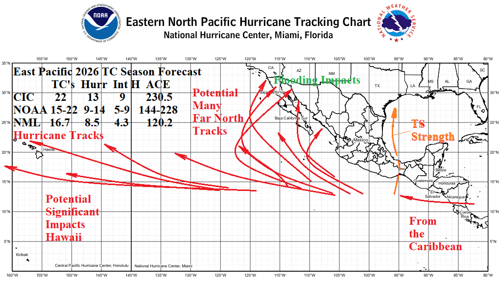
Fig. 1: The Climate Impact Company 2026 tropical cyclone season forecast for the East Pacific basin.
Climate discussion: Well-known is the likelihood of above normal tropical cyclone activity in the East Pacific basin during El Nino episodes. The eastern equatorial Pacific Ocean is warming now and a vigorous El Nino is forecast to develop during the 2026 tropical cyclone season. However, of equal concern is the ongoing marine heatwave (MHW) off the Southwest Coast of North America (Fig. 2) which should allow northward turning storms to maintain intensity longer and carry impacts, especially flooding rainfall, well inland across Mexico into the Southwest U.S. possibly affecting Southern California as suggested by the NOAA AUG/SEP/OCT 2026 precipitation probability outlook (Fig. 3). There is (also) risk of tropical systems crossing Central America into the East Pacific and/or across Southeast Mexico into the western Gulf of Mexico although not a hurricane risk. Warm ocean waters extend well to the west in both the tropics and subtropics increasing the risk of several hurricanes reaching Hawaiian waters.
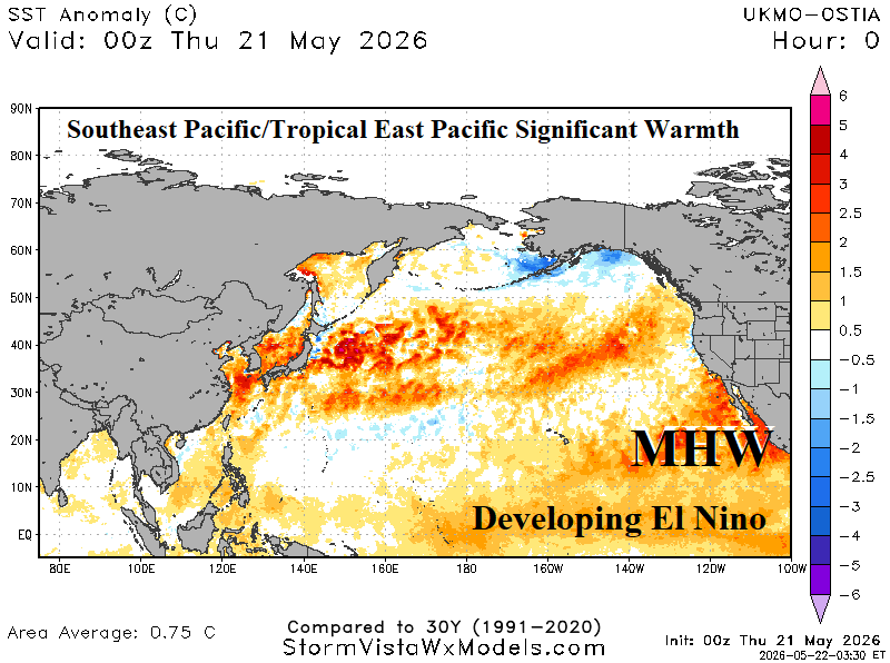
Fig. 2: Current Pacific Basin SSTA analysis reveals developing El Nino and a strong marine heatwave off the Southwest Coast of North America.
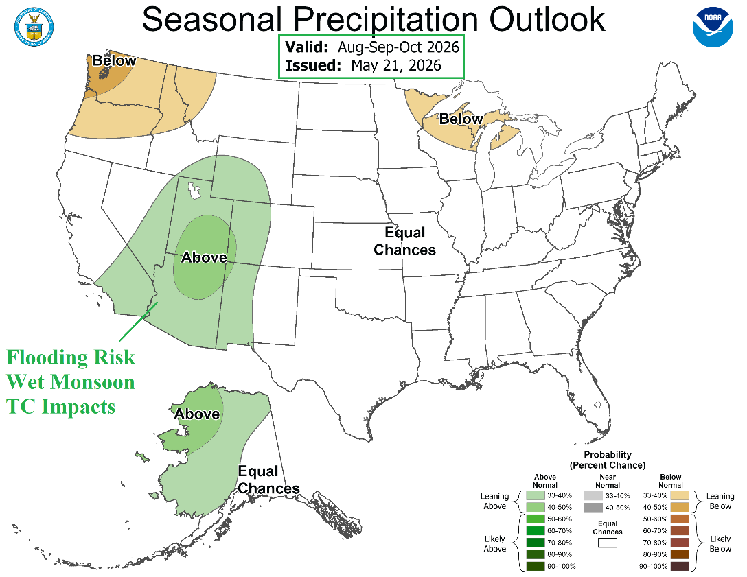
Fig. 3: The NOAA/CPC AUG/SEP/OCT 2026 precipitation probability forecast indicates an unusually strong Southwest U.S. Monsoon enhanced by impacts of inland traveling tropical cyclones.
| Year | Weight | Tropical Storms | Hurricanes | Major Hurricanes | ACE Index |
| 2023 | 2 | 17 | 10 | 8 | 165.1 |
| 2018 | 1 | 23 | 13 | 10 | 318.1 |
| 2016 | 1 | 21 | 13 | 6 | 184.9 |
| 2015 | 2 | 26 | 16 | 11 | 288.9 |
| 2014 | 1 | 22 | 16 | 9 | 202.4 |
| Average | 21.7 | 13.4 | 9.0 | 230.5 | |
| Forecast | 22 | 13 | 9 | 231 | |
| Normal | 16.7 | 8.5 | 4.3 | 120.2 |
Table 1: The East Pacific seasonal tropical cyclone activity forecast based on analog years.