12/09/2025, 9:06 am EST
A graph of a graph of the price of a market AI-generated content may be incorrect.

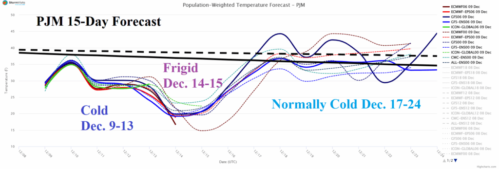
Deepening Snow Cover Helps To Produce Extreme Northeast Cold Early Next Week

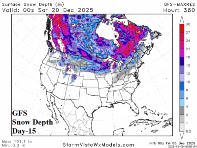
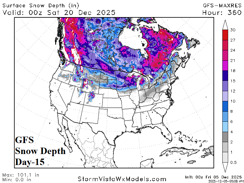
Snowfall forecasts by NBM indicate moderate to heavy snow across the Upper Midwest, Great Lakes, and Interior Northeast States today through tomorrow. More snow although not as heavy extends across the North-central U.S. to the Interior Northeast States later this week. More snow is likely from the Ohio Valley across the Northeast States this weekend. The ongoing snowfall leaves deep snow cover for the Midwest to the Northeast by middle of next week (Fig. 6). The deepening snow enhances arctic air presence peaking in strength early next week across the PJM System.
12/09/2025, 4:55 am EST
A map of the world AI-generated content may be incorrect.

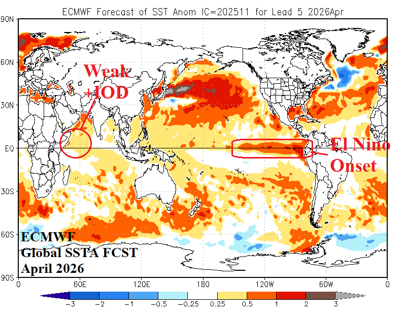
La Nina Shifts to Neutral Phase Early 2026; El Nino in 2026 is Likely

La Nina has recently weakened. Some regeneration is possible for later this month/early January. However, the push toward warming by a recent intense MJO event suggests the weak late 2026 La Nina has peaked, and neutral ENSO generates for Q1/2026. The warming Northeast Pacific generated in-part by the recent intense MJO event requires monitoring. Often, warming of the Northeast Pacific is a precursor to an ENSO phase change toward El Nino. ECMWF and NMME (models) forecast El Nino onset during Q2/2026.
12/08/2025, 2:59 pm EST
A graph with blue lines and text AI-generated content may be incorrect.

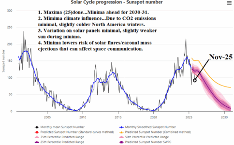
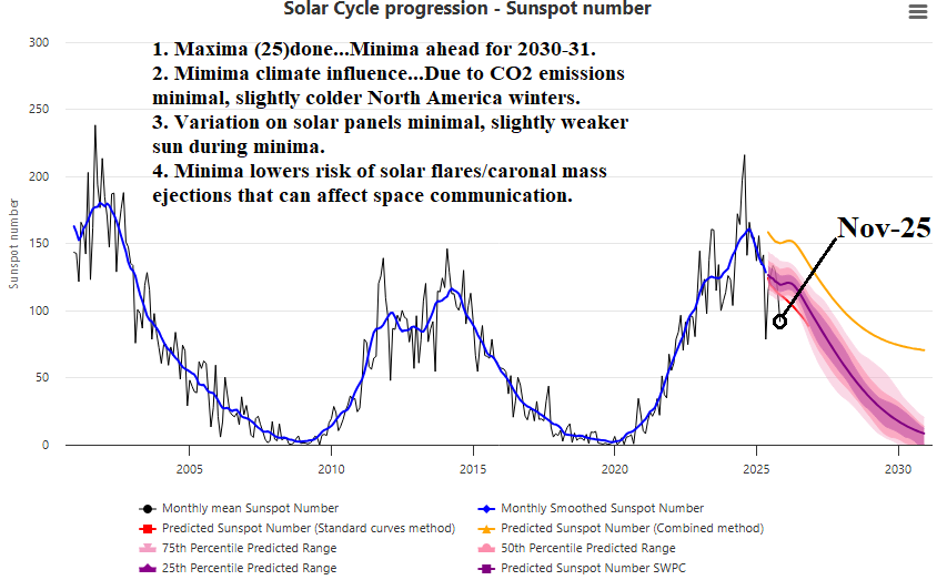
NOV-25 Solar Cycle/Sunspot Number: Deceleration to Solar Minimum Underway

Solar cycle maxima 25 has passed and the NOV-25 sunspot number indicates deceleration toward solar minima likely by 2030-31 is underway. Common questions are influences on climate which is minimal due to CO2 emissions although slightly colder North America winters are favored. There are minimal effects on solar panels due to a weaker sun during solar minimum.
12/08/2025, 4:30 am EST
A map of a storm AI-generated content may be incorrect.

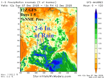
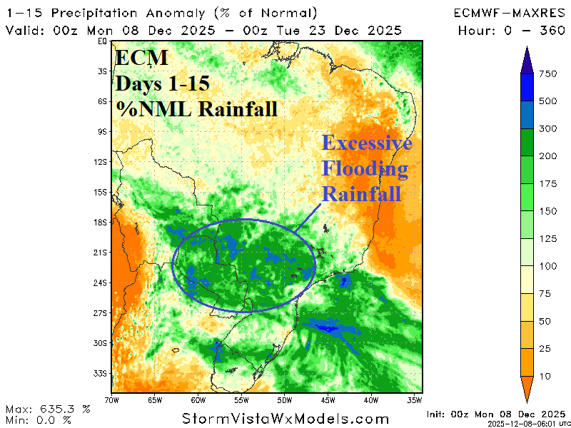
Excessive Rainfall Forecast by ECM Central/East-central South America.

ECM indicates potential for flooding rainfall during the middle third of December across Eastern Bolivia, Paraguay, and Southwest/Southeast Brazil. The rain may abate in the 11-15-day period. The 24-hour change indicates a significant increase in rainfall for Paraguay and eastward. The culprit is an intensifying upper trough extending from east of Argentina northwestward into Brazil during much of the next 2 weeks.
12/08/2025, 4:27 am EST
A map of the united states AI-generated content may be incorrect.

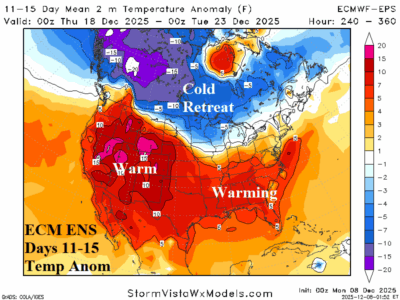
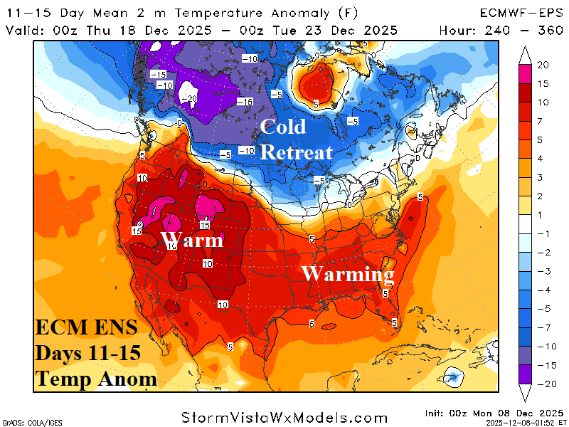
Cold Retreat, Operational/AI Models Warm U.S. Extended-range

Theme of the Monday morning extended range U.S. temperature anomaly forecast is warmer. The most dramatic warmer change is the consensus of operational models forecast for the week ending Christmas Day and AI projections for early January.
12/07/2025, 2:50 pm EST
A graph showing the weather forecasts AI-generated content may be incorrect.

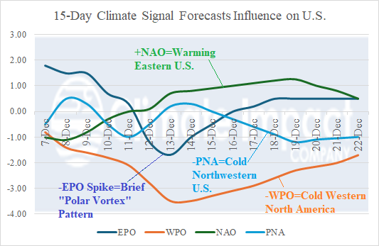
In U.S. Climate Signals Support Colder West/Warmer East Extended-range

Climate signals forecasts identify provide clues as to where the weather pattern is heading after mid-December. The West Pacific oscillation (WPO) and Pacific North America (PNA) index is negative after mid-December supporting a shift and expansion of the cold pattern over western North America. Negative East Pacific oscillation (-EPO) spikes in one week as another “polar vortex” cold outbreak strikes the U.S. The North Atlantic oscillation (NAO) aggressively shifts to positive phase during the medium range supporting an eastern North America warm-up and validating the -WPO/-PNA colder support in the West. The question is whether -NAO warmth can eat away at the snow cover validating very warm 11-15-day forecasts by ECM.
12/07/2025, 2:46 pm EST
A map of a storm AI-generated content may be incorrect.

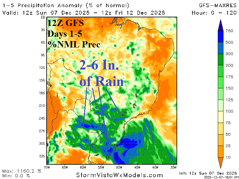
Deluge of Rain for Central/East-central South America

In South America, rainfall forecasts have shifted wet risk to Brazil during the past 1-2 weeks. The 7-day percent of normal observed rainfall identifies wetter Brazil weather while rains linger in Argentina. Low pressure areas spawn heavy rain the next 1-2 days Paraguay into Brazil and Northeast Argentina late this week. Additional heavy rain is projected in the 6-10-day and 11-15-day period centered east of Paraguay.
12/05/2025, 6:30 am EST
A graph of snow cover anomalies AI-generated content may be incorrect.

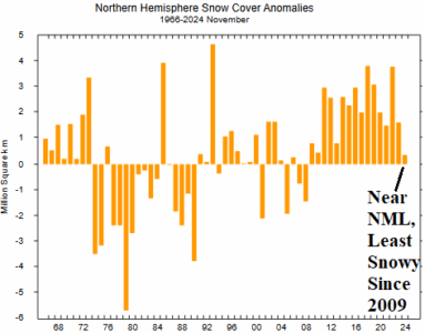
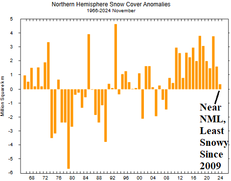
Northern Hemisphere Snow Cover for NOV-25 Near Normal But Lowest Amount Since 2009

The North America and Eurasia snow cover during November were near normal and consequently northern hemisphere snow cover was near normal and the least snowy since November 2009. Note one of the coldest winter seasons on record followed as DEC/JAN/FEB 2009-10 was frigid! Early season snow cover dictating the following winter weather pattern was a reasonably reliable climate diagnostic late last century but less so in this century.
12/05/2025, 6:22 am EST
A map of the world AI-generated content may be incorrect.

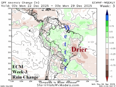
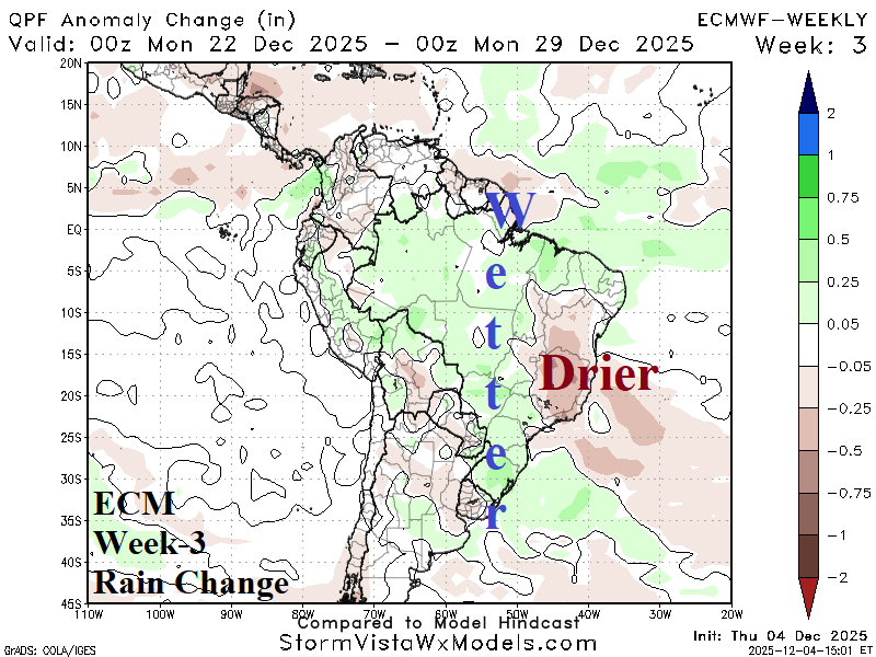
Wetter Brazil Short-term but Longer-term Forecasts Less Wet East Brazil

An upper trough on the Southeast Brazil Coast as projected by climate forecasts for early calendar summer is not there. Instead, weak low pressure across Central Brazil fuels wetter than normal conditions for Central Brazil while East Brazil is trending drier. Argentina is drier and hotter than normal.
12/04/2025, 4:51 am EST
A graph showing the average temperature AI-generated content may be incorrect.

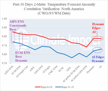
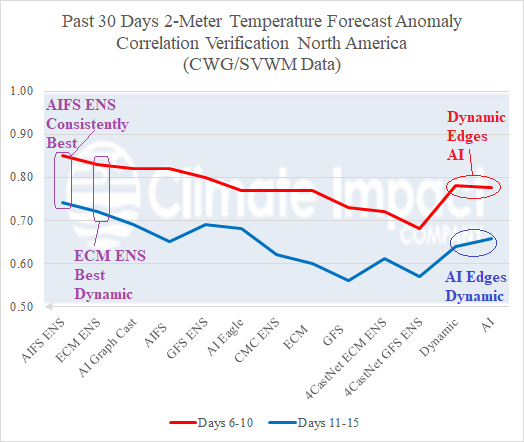
Dynamic/AI Models Verification Report: AIFS skill scores are best for medium range North America/Europe temperature forecasts; Ongoing wet bias in Brazil.

Given the sharp increase in medium-range temperature anomaly forecasts for North America and Europe as meteorological winter 2025-26 arrives a review of 30-day skill scores using anomaly correlation is provided. For North America, as observed throughout most of 2025, AIFS ENS and ECM ENS are the top 2 forecast models. Anomaly correlation skill scores in the 0.85 range for the 6-to-10-day period are considered good too very good with a similar reliability near 0.70 in the 11-15-day period.
12/02/2025, 1:11 pm EST
A graph of different colored lines AI-generated content may be incorrect.

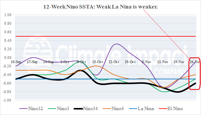
Is La Nina Starting to End?

Last week, the NINO SSTA regions warmed including the Nino 4 (near the Dateline) and Nino12 (northwest coast of South America) where sea surface temperature anomalies (SSTA) shifted to neutral phase. The Nino34 SSTA barely remains within the La Nina threshold. The warming is likely due to weakening trade winds slowing the upwelling of cool water process.