
Is La Nina Starting to End?
12/02/2025, 1:11 pm EST
In U.S. Climate Signals Support Colder West/Warmer East Extended-range
12/07/2025, 2:50 pm EST
Climate Impact Company Early U.S. Notes
Issued: Friday December 5, 2025


Fig. 1-2: The morning NOAA/NWS weather watch, warning, and advisory areas plus today’s NBM snowfall forecast across Virginia.
Discussion: Snow cover is above normal from New Mexico to Nebraska eastward to the Mid-Atlantic States. Additional snowfall is on the way. A Winter Storm Warning for heavy snow is posted across the Central and Northern Rockies with a Winter Storm Watch issued for Iowa more moderate snow into the weekend (Fig. 1). A Winter Weather Advisory is posted for Virginia’s private snowfall forecast between 2 and 4 inches by the NBM (model) for today (Fig. 2). Remember, cold bias to temperature forecasts with snow cover! Snow cover extends across much of the northern half of the U.S. east of the Continental Divide today (Fig. 3) retreating slightly in the East during the next 2 weeks while building dramatically over Western Canada to the North-central U.S. (Fig. 4) where arctic air generation is likely. The U.S. gas population weight HDD forecast utilizing all models increases sharply for next week as longer term forecasts continue to shift colder once within 2-week targets (Fig. 5). The Climate Impact Company estimated week 4-6 HDD forecasts comparing the consensus of 3 AI models and CFS/ECM indicates coldest bias continues with AI with a trend toward or slightly warmer than normal in early January. The AI and CFS/ECM forecasts each have large ranges from very warm to very cold therefore low confidence. This week’s projected HDD is near 204. The week-4 projection for this week from early November was 189 (AI) and 177 (CFS/ECM). The likely colder verification is notable!

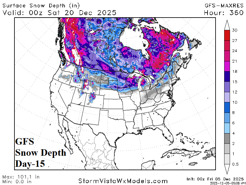
Fig. 3-4: The GFS snow depth forecast for today and 15 days from now.
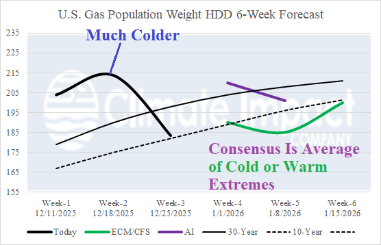
Fig. 5: U.S. gas population weight HDD forecast through Christmas Day based on all models and their consensus plus the estimated HDD based on 3 AI models and the CFS/ECM consensus for week 4-6 ahead.