Monitoring The 30-31C/86-87F SST Presence In The North Atlantic Basin
07/23/2023, 3:45 pm EDTScary Tropical/Subtropical North Atlantic Basin SSTA as The Most Active Part of TC Season Begins
08/06/2023, 11:12 am EDT
Executive summary: Yet another surprise, likely unknown is ahead for the winter 2023-24 northern hemisphere winter. For the first time in recorded history, the combination of an over-achieving solar maxima, El Nino climate, and much warmer than normal ocean surface is likely to drive the winter 2023-24 northern hemisphere climate pattern. During solar cycles 21, 22, and 23 moderate-to-strong solar maxima occurring with El Nino consistently rendered stronger than normal upper level stormy and/or cold trough patterns in the northern hemisphere. Featured were excessive precipitation across the Southern U.S. while Eastern Canada was very cold. Will these patterns repeat during winter 2023-24, be stronger as a cold upper atmosphere combined with warm oceans makes storms stronger, or will the ocean modify these upper trough patterns?
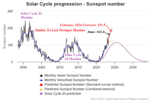
Fig. 1: Solar Cycle 25 continues to intensify more rapidly than originally expected and is likely to reach strength of Solar Cycle 23 maxima next year.
Discussion: Solar Cycle 25 sunspot number continues to over-achieve reaching 163.4 in June with a higher number anticipated for July and well above earlier projections by NASA (Fig. 1). The most recent sunspot number projection for later this upcoming northern hemisphere meteorological winter is 191.5 as solar cycle 25 maxima begins. The projected value has similar intensity to solar maxima cycles 21, 22, and 23 (Fig. 2). There is a risk that Solar Cycle 25 maxima could exceed each of these previous strong solar maxima episodes. Interestingly, moderate-to-strong El Nino occurred during or just after solar maxima 21, 22, and 23. During DEC/JAN/FEB of each El Nino year while the sun was active there was a tendency in the northern hemisphere of unusually strong upper level stormy and/or cold trough patterns (Fig. 3). The sensible weather pattern featured cold-air source region(s) across Eastern Canada, Southern Europe, and the Black Sea region, plus Southern China (Fig. 4). Mild climate zones were present across Southwest Canada and Central Russia. The precipitation pattern produced a wet extreme across the Southern U.S. while Europe was dry (Fig. 5). The solar maxima and El Nino combination for northern hemisphere winter 2023-24 could produce a similar result. However, there is a caveat. The ocean surface nowadays which features a new phenomenon, widespread marine heat waves (Fig. 6) is much warmer than the ocean surface typical of El Nino events in the past when outside the tropics, the ocean surface was much cooler (Fig. 7).
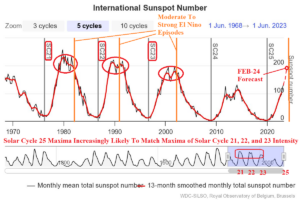
Fig. 2: Solar Cycle 25 maxima is likely to reach (or exceed) the intensity of solar cycle maxima 21, 22, and 23.
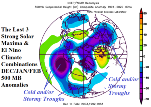
Fig. 3: El Nino episodes occurring during solar cycle 21, 22, and 23 maxima northern hemisphere winter (DEC/JAN/FEB) 500 MB anomalies.
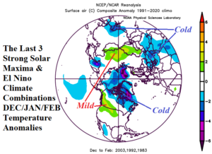
Fig. 4: El Nino episodes occurring during solar cycle 21, 22, and 23 maxima northern hemisphere winter (DEC/JAN/FEB) temperature anomalies.
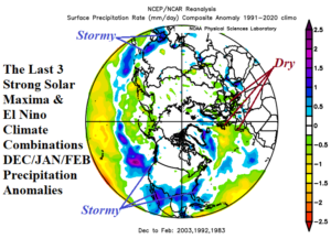
Fig. 5: El Nino episodes occurring during solar cycle 21, 22, and 23 maxima northern hemisphere winter (DEC/JAN/FEB) precipitation anomalies.
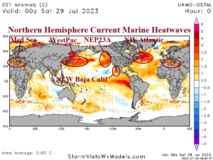
Fig. 6: Global SSTA analysis for late July 2023 including identification of northern hemisphere marine heat waves.
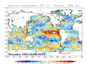
Fig. 7: El Nino December 1982 and the cooler than normal poleward ocean surface.
Conclusion: Yet another unusual climate circumstance is ahead for the northern hemisphere winter 2023-24. The unique combination of an over-achieving active sun, El Nino climate, and unusually warm global ocean surface is likely to deliver climate surprises. In the past, the last active solar maxima’s have caused stormy and/or cold trough patterns across the northern hemisphere during meteorological winter. The strongest sensible weather patterns have been a very stormy winter across the Southern U.S. with a strong cold-air source region across Eastern Canada. Unclear is whether a much warmer ocean surface will cause these upper air patterns to emerge with more intensity due to increased thermal contrast between cold upper air features and warmer oceans or whether the warmer oceans modify the cold upper trough patterns.