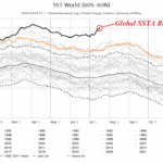
Record Warm Global Temperatures Caused by Marine Heat Waves
07/18/2023, 2:15 pm EDT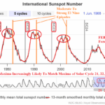
Solar Maxima, El Nino Climate, and Record Warm Ocean for Winter 2023-24 Ahead
07/31/2023, 7:57 am EDT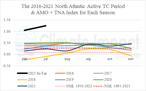
Executive summary: For the first time in the historical record, accumulated cyclone energy (ACE) index was above normal for a 6-year period (2016-21) averaging 159 which is considerably higher than normal (126). One of the primary contributors to the active period is the much warmer than normal North Atlantic basin sea surface temperature (SST) pattern featuring increased frequency of unusually warm SST of 30-31C (or warmer) which ignites major hurricanes. Recently, Colorado State University and Climate Impact Company significantly raised their ACE index forecasts for 2023 to levels above the 2016-21 normal. Once again, the primary reason for the sharp increase in ACE, is the unprecedented warming of the North Atlantic basin which includes large zones of 30-31C (or warmer) SST regions for areas where tropical cyclones track during AUG/SEP/OCT on their way to or near the U.S. Coast. Despite an evolving El Nino, an unprecedented risk of strong tropical cyclones in 2023 is present due to the extremely warm water surface.
Discussion: Accumulated cyclone energy (ACE) is defined as the sum of the squares of the estimated 6-hourly maximum sustained wind speed for all tropical cyclones. ACE index is helpful as a historical statistic identifying intensity of a tropical cyclone and collectively for all tropical cyclones in one season. ACE index is now part of seasonal tropical cyclone outlooks. Recently, the ACE index forecast for the 2023 North Atlantic basin tropical cyclone season was raised (160-171) to above normal (126) by Colorado State University and Climate Impact Company (Table 1) primarily due to the unprecedented anomalous warmth of the North Atlantic. The somewhat higher than normal ACE index forecast for an expected El Nino year is unique.
| Tropical Storms | Hurricanes | Intense Hurricanes | ACE Index | |
| CIC New | 20 | 9 | 4 | 171 |
| CSU New | 18 | 9 | 4 | 160 |
| TSR/UK New | 17 | 8 | 3 | 125 |
| CIC Old | 13 | 7 | 3 | 136 |
| CSU Old | 15 | 7 | 3 | 125 |
| TSR/UK Old | 13 | 6 | 2 | 90 |
| NOAA | 12-17 | 5-9 | 1-4 | N/A |
| 30-Year | 15.0 | 7.4 | 3.2 | 126.4 |
Table 1: North Atlantic basin seasonal tropical cyclone activity forecast by all leading providers compared to the 30-year normal including ACE index.
During 2016-2021, the seasonal ACE index average was 159 which is the highest value for any 6-year period in the historical record when each year of that 6-year period produced above normal ACE. Last year, the ACE index slipped below normal (95). During most of the 6-year active tropical cyclone season period, not surprisingly, the North Atlantic basin was much warmer than normal as defined by combining the basin-wide Atlantic multi-decadal oscillation (AMO) and the tropics-oriented tropical North Atlantic (TNA) index (Fig. 1). The one exception is 2018 when all but 3 tropical systems generated, tracked through the subtropics (or farther north) and generally avoided the temperate SST pattern in the deep tropics.
In 2023 so far, the AMO and TNA combination is the warmest on record indicating the North Atlantic surface and upper ocean heat is unprecedently plentiful for tropical cyclone development and intensification.
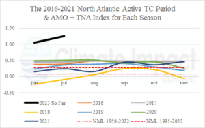
Fig. 1: The generally much warmer than normal North Atlantic basin as defined by Atlantic multi-decadal oscillation (AMO) plus tropical North Atlantic (TNA) index during June through November of 2016-2021. Note the record warmth of 2023 so far.
During the recent uptick of North Atlantic tropical cyclone activity, exceptionally warm SST observed in the western North Atlantic basin has increased. When tropical cyclones move into 30-31C/86-87F (or warmer) SST zones, rapid intensification to a major hurricane occurs. Currently, areas of SST at 30-31C (or warmer) are widespread in the Gulf of Mexico (Fig. 2) to the Caribbean Sea (Fig. 3) and Bahamas (Fig. 4). These areas of super-warm ocean surface temperature are part of a much warmer than normal North Atlantic basin (Fig. 5). Tropical cyclones developing in AUG/SEP/OCT that move across these very warm water zones have an above average risk of rapid intensification to category 3, 4, or 5 major hurricanes.
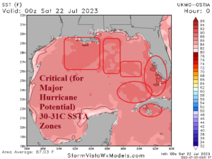
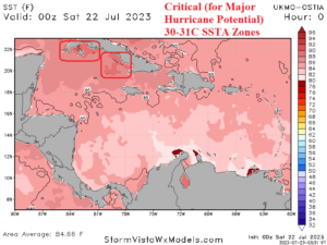
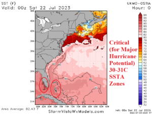
Fig. 2-4: Areas of 30-31C/86-87F (or warmer) in the Gulf of Mexico, Caribbean Sea, and Bahamas.
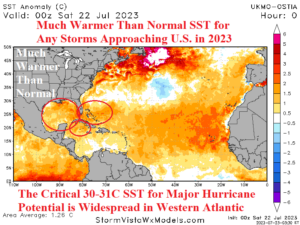
Fig. 5: The much warmer than normal North Atlantic basin.