Solar Maxima, El Nino Climate, and Record Warm Ocean for Winter 2023-24 Ahead
07/31/2023, 7:57 am EDTMarine Heat Waves Remain Dominant, Influence El Nino 2023-24
08/15/2023, 8:09 am EDTExecutive summary: We’ve entered the most active part of the North Atlantic basin tropical cyclone season (after Aug. 1st). For now, the basin is all clear. However, normal to above normal hurricanes/major hurricanes remain in the forecast primarily due to the record warm surface of the North Atlantic tropics/subtropics. The forecast is unique, a potential big year for hurricanes in the face of a developing El Nino climate. Provided are the latest daily SSTA analysis for the Gulf of Mexico, western North Atlantic, and main development region (MDR) in the outer tropics. The Gulf and MDR are record warm. Given the super warm SST, if the proper environment evolves, the potential for unusually strong hurricanes is high!
Discussion: Of concern is Colorado State University (CSU) did not lower their seasonal North Atlantic basin tropical cyclone season forecast which was raised in early July to 18 storms, 9 hurricanes, and 4 major hurricanes with a robust ACE index of 160 in their August 3rd update. Earlier this month (August 1st), a similar (July) projection by Climate Impact Company was lowered slightly respecting an emerging El Nino climate and the attendant suppression of tropical cyclone activity due to increased upper-level westerly shear. Of interest will be the updated forecast from Tropical Storm Risk/U.K. on August 7th.
The issue here, and this has not occurred before in the time frame where data is available, the record warm ocean surface of the North Atlantic basin coupled with an oncoming El Nino. The super warm tropics/subtropics of the North Atlantic basin support a big year for hurricanes while an emerging potentially strong El Nino historically leads to minimal activity.
The SST/SSTA patterns across the North Atlantic basin where tropical cyclones form and track is critical! Let’s look at where we stand as of today.
First, the Gulf of Mexico SST/SSTA pattern is flat-out scary. The basin SSTA is +1.24C! I’ve never seen a warm anomaly of this strength for this region. The actual SST are in the upper 80’sF/low 90’sF off the coast of Louisiana and west/southwest Florida. As a reference, SST of 87F (or higher) caused rapid intensification (as major hurricanes) of storms making landfall in the Gulf of Mexico during recent years. Those (SST) conditions are exceeded in early August 2023. The implication is upper ocean heat/fuel to allow tropical cyclones to intensify is IMMENSE in the Gulf of Mexico especially near the U.S. Coastline.
Second, while SST has cooled significantly off the Northeast U.S. Corridor Coast the past 1-2 weeks, the SSTA pattern in the Bahamas is robust warm averaging 1.0C to 2.5C above normal. SST east of southeast Florida is widespread upper 80’sF.
Finally, in the main development region (MDR) in-between the Caribbean Sea and coastal Northwest Africa where SSTA is conveniently observed by the tropical North Atlantic (TNA) index is a record +1.23C and as of the past 7-10 days steady in intensity. Implied, is ample upper ocean heat to allow developing tropical cyclones to develop rapidly and make more likely a system has an increased chance of reaching the western North Atlantic tropics.
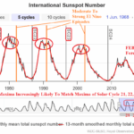
As for El Nino, one leading diagnostic to determine whether an El Nino climate is developing, is to monitor the southern oscillation index (SOI) which accounts for the atmospheric reaction to the equatorial SSTA environment. The SOI plunged in May to -1.53 which effectively ended the 2020-23 La Nina climate pattern. Since that time, June and July averaged weak negative SOI (-0.326). However, an El Nino climate supporting stronger -SOI regime appeared July 17-28 and redeveloped the past several days.
Conclusions: Currently, the North Atlantic basin is ALL CLEAR. Forecast models are not consistently indicating any development through the next 10 days. There are some signs of life in the tropics in the 11-15-day period. Two concerns: If the CSU forecast is correct, we’ll have 14 additional storms, 9 hurricanes, and 4 major hurricanes (CIC indicates 13/6/2) all of which begin during the last third of August. By OCT/NOV there is a reasonable certainty we’ll be in a tropical cyclone-defeating El Nino climate. The implication is an extremely active and potentially unusually dangerous late AUG/SEP/early OCT tropical cyclone pattern in the North Atlantic ahead. The second concern is tropical cyclone activity can develop fast in short-term outlooks and not necessarily be seen 10+ days out for monitoring purposes.
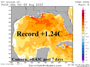
Fig. 1: The Gulf of Mexico basin current SSTA analysis.
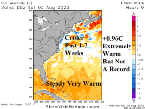
Fig. 2: The western North Atlantic basin current SSTA analysis.
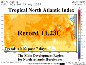
Fig. 3: The main development region (MDR) current SSTA analysis